


Satellites see the highs and lows of the biggest lake in China
Image of the Month - March 2017
Since 1992, 22 March is World Water Day for Unesco, to inform people on problems linked to this vital resource and its management.
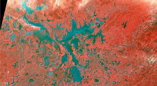
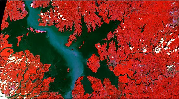
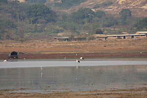
Poyang Lake, in Jiangxi province in China, is one of the world’s richest areas for biodiversity. More than 300 species of birds, at least a dozen of which are considered to be in danger of extinction, depend on habitats they find in the catchment basin, particularly for overwintering. The most well-known of these are Siberian cranes and Oriental storks (two species each with fewer than 3000 individuals remaining) and almost the entire world population for each comes to spend the winter at Poyang. The wide diversity of migrating water birds found there is directly due to the lake’s complex hydrology, which affects the vegetation they feed on. The lake is also the biggest freshwater reserve in China, its neighbour (Dongting Lake) being the second.
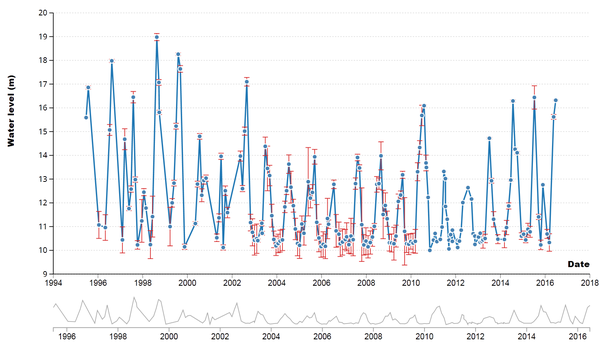
It is a monsoon lake with great variations in volume between the dry season, from November to March, and the wet season from June to September. On average the water surface areas drop from 3000 to 3500 km² in summer to 1000 km² in winter, with a difference in water level of about 10 m. During the dry season, the Poyang basin consists of a central depression filled with water and disconnected lakes surrounded by huge mudflats covered by grassy vegetation. When the water level rises during the wet season, the central depression fills up until water gradually reaches the level of the lakes so that the whole complex forms a single, small, inland sea.
Observations show that there is strong inter-annual variation in terms of both filling and emptying dates for the lake and of filling rate. Between 2009 and 2015, it was noted that the lake began emptying very early in the season (from July) and that the filling was occurring later and later. Thus, in the spring of 2010, it was estimated that the lake finally filled two and a half months late. Conversely, at the end of June 2010 the lake filled up very quickly and significantly, with water levels close to those of the catastrophic floods of 1998. The summer of 2010 was noteworthy for the very long period of high water levels, which remained high until the end of September of that year. For the period from 2000 to 2015, it was during the winter of 2003 to 2004 and then from 2006 to 2007 and then again from 2013 to 2014 that the lowest surface areas were observed, down to about 550 km². Conversely, during the winter of 2015 to 2016 the water surface areas remained significantly high, due to El Niño and La Niña effects.
Two main causes of these droughts have been identified. On the one hand the water from the Yangtze is being retained by the Three Gorges dam upstream from Lake Poyang. Now the Yangtze plays the role of a hydraulic gate, in other words when its discharge is high it stops the lake’s waters from emptying into it, and sometimes when its discharge is extremely high, water from the Yangtze enters the lake. When the river water is retained by the dam during the winter period (to guarantee sufficient discharge for running the turbines), water from Poyang tends to flow into the river. Another reason is climate change: it has been noted that there is a general lowering of water resources in the Yangtze basin, particularly a lack of rainfall during the wet season in the upstream part of the catchment area.
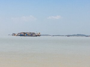
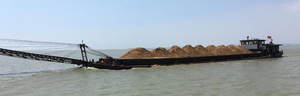
There are two other elements which affect the water system of Poyang. The first is the excessive exploitation of the bottom of the lake for extracting sand. The Poyang basin is the leading source of sand used for building in China, supplying about 10% of the total Chinese demand. This activity leads to a widening and especially to excessive deepening of the bottom of the gully bringing water from the lake to the Yangtze. This leads to faster than normal emptying of the lake and hence a loss of water. The second element is the fact that the lakes that maintain their level during the dry season are increasingly used for fish-farming and are periodically drained, which intensifies the drought aspect.
Ideas for the future of Poyang include creating a dam to regulate the water level and developing fish-farming, both of which would have a strong impact on biodiversity. Another solution might be found through eco-tourism.
The Sertit platform of the ICube laboratory at the University of Strasbourg , in partnership with Chinese teams, has been monitoring variations in surface levels of Poyang Lake for nearly 15 years, using medium and high resolution satellite data acquired approximately every 10 days. Legos and CNES have been monitoring variations in the lake surface heights using measurements taken by altimetry satellites.
The future SWOT mission will enable monitoring of both the height and the surface area of the lake by means of the wide-swath radar interferometer to be carried on the satellite.
See also:
- Applications: High-resolution hydrology
- Applications: lakes and enclosed seas
- Missions: Swot
Other websites on this topic:
- Hydroweb on Theia web site
References
- Hervé Yesou , Eric Pottier, Grégoire Mercier, Manuel Grizonnet, Sadri Haouet, Alain Giros, Robin Faivre, Jérome Maxant, Mathias Studer, Claire, 2016 : Synergy of Sentinel1 and Sentinel2 imagery for wetland monitoring. Information extraction from continuous flow of Sentinel images applied to water bodies and vegetation mapping and monitoring. Proceedings IGARSS 2016, 10-15 July 2016 Beijing, PR China
- Hervé Yésou, Claire HUBER, Sadri HAOUET, Xijun LAI, Shifeng HUANG, Paul de FRAIPONT, & Yves Louis DESNOS, 2016: Exploitating Sentinel1 time series to monitor the largest feresh water bodies in PR China. The Poyang lake case. Proceedings IGARSS 2016, 10-15 July 2016 Beijing, PR China
- Daillet Sylviane, Huber Claire, Lai Xijun, Huang Shifeng, Chen Xiaoling, Uribe Carlos, Crétaux Jean-François, Gennero Marie-Claude, Yésou Hervé 2014 : Large monsoon lakes monitoring in China exploiting ENVISAT, Topex/Poseidon, JASON and ALTIKA altimetry missions: yearly variations and global trends for Poyang and Dongting lakes (P.R. China). Proceedings Mid Term Results of Dragon III, 26-28 May 2014, Chengdu, Sichuan Pr., PR China. ESA SPS 742
- Cao, L., Fox, A.D., 2009. Birds and people both depend on China’s wetlands. Nature 460, 173-173. dx.doi.org/10.1038/460
News
 Archives .
- Aviso Newsletter .
- Search.
- Front-page news.
- Image of the month .
- 2026 .
- 2025 .
- 2024 .
- 2023 .
- 2022 .
- 2021 .
- 2020 .
- 2019 .
- 2018 .
- 2017 .
- Dec. 2017: Sea Level Rise impacts on Miami.
- Nov. 2017: Tracking water bodies.
- Oct. 2017: Plate tectonics.
- Sep. 2017: 25 years, and many more to come.
- Aug. 2017: Waves & currents.
- Jul. 2017: Higher resolution knowledge of flooded areas over the whole Earth.
- Jun. 2017: Eddies everywhere.
- May 2017: Ocean mirrors the deep.
- Apr. 2017: How El Niño and related sea level fall impacted indonesian corals.
- Mar. 2017: Satellites see the highs and lows of the biggest lake in China.
- Feb. 2017: Tidal currents make a buoy's path spiral.
- Jan. 2017: Wave model with ice.
- 2016 .
- 2015 .
- 2014 .
- 2013 .
- 2012 .
- 2011 .
- 2010 .
- 2009 .
- 2008 .
- 2007 .
- 2006 .
- 2005 .
- 2004 .
- 2003 .
- 2002 .
- 2001 .
- 2000 .
- 1999 .
- 1998 .
- Operational news and status .