Tracking water bodies
Image of the Month - November 2017
Satellite radar nadir altimeters have been widely used to measure river and lake surface water elevations for the last two decades.
However, since these instruments are primarily designed to observe ocean surface topography, they are not always able to observe the inland waters. For steep-banked rivers (i.e. in valleys not wider than a few kilometers and surrounded by slopes higher than 50 m), altimeters tend to observe the top of the surrounding topography rather than the river itself. This occurs for all river widths, but is more frequent for smaller rivers. The altimeter onboard Jason-3, launched in January 2016, has an alternative instrument operation mode, the so called Digital Elevation Model (Diode/DEM) tracking mode or Open-Loop mode (OL) which is designed to overcome this issue.
However, using this tracking mode requires an a priori knowledge of the target elevation with a rather good exactitude (typically a dozen of meters). It is not trivial to collect data which meet this constraint on a global scale.
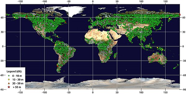
This is why, given the interest for the entire hydrological community, LEGOS and CNES teams have combined their technical and scientific expertise to implement the right strategy. The database was thus recently enlarged with about 4300 targets around the world to build the new Jason-3 onboard DEM which was downloaded at the end of August and has been activated since Cycle 57, track 160.
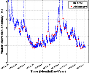
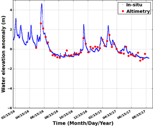
This upload has been very successful and the validation done over four cycles shows that the altimeter performance over inland waters was significantly improved. For example, it has been shown that "small" rivers such as the Loire or the Garonne in France which were never observed in the past by the Jason satellites, are now observed for each overpass. In the future, we intend to further increase the size of the database for Jason-3 and do the same work for Sentinel-3. This will prepare for the very large progress in hydrology that will be brought by SWOT in the near future.
See also:
- Applications: High-resolution hydrology
- Missions: Swot
References
-
Blumstein D., S. Biancamaria, J.-F.Crétaux, S. Calmant, F. Blarel, F. Frappart, S. Fleury, E. Zakharova, S. Le Gac, F. Boy, N. Picot, A Database Of Hydrology Targets For The New DEM Onboard Jason3, OSTST 2017, Miami
- Biancamaria et al., Validation of Jason-3 tracking modes over French rivers, RSE, in review.
- Le Gac S., Update and validation of the onboard Jason-3 DEM for enhanced acquisitions over inland water targets, OSTST 2017, Miami


