


Wave model with ice
Image of the Month - January 2017
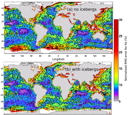
The Southern ocean high waves are almost a cliché. Even if the highest waves may not be detected there (but rather in the North Atlantic), this Ocean has often very rough sea states. One of its other pecularities is the presence of icebergs, threatening navigation too. Since there's few in situ measurements in the region, satellite observation and modelling are of a particular importance there.
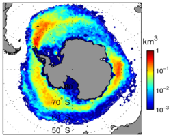
Wave models, which modelize wave heights and directions, did not take into account icebergs at first. But when iceberg distribution maps (from altimetry) were released, biases in wave models and iceberg distributions looked strangely alike... Investigations showed that icebergs are dampening waves, in fact. So, if you don't take them into account, you modelize waves even higher than the actual ones in the iceberg areas.
Altimetry can help for both subjects - significant wave height measurements and iceberg detection. With the CFOSat mission (CNSA/Cnes), a dedicated wave-measurement instrument similar to altimeters will be launched (planned 2018).
See also:
- Image of the Month, September 2013: Icebergs on the move
- Image of the Month, November 2008: Counting icebergs
- Applications: Ice sheets and sea ice
- Applications: wind and waves
Other website on this subject:
- the database used to produce the iceberg plot is available throught Ifremer's Cersat center, at ftp://ftp.ifremer.fr/ifremer/cersat/products/gridded/altiberg/
News
 Archives .
- Aviso Newsletter .
- Search.
- Front-page news.
- Image of the month .
- 2026 .
- 2025 .
- 2024 .
- 2023 .
- 2022 .
- 2021 .
- 2020 .
- 2019 .
- 2018 .
- 2017 .
- Dec. 2017: Sea Level Rise impacts on Miami.
- Nov. 2017: Tracking water bodies.
- Oct. 2017: Plate tectonics.
- Sep. 2017: 25 years, and many more to come.
- Aug. 2017: Waves & currents.
- Jul. 2017: Higher resolution knowledge of flooded areas over the whole Earth.
- Jun. 2017: Eddies everywhere.
- May 2017: Ocean mirrors the deep.
- Apr. 2017: How El Niño and related sea level fall impacted indonesian corals.
- Mar. 2017: Satellites see the highs and lows of the biggest lake in China.
- Feb. 2017: Tidal currents make a buoy's path spiral.
- Jan. 2017: Wave model with ice.
- 2016 .
- 2015 .
- 2014 .
- 2013 .
- 2012 .
- 2011 .
- 2010 .
- 2009 .
- 2008 .
- 2007 .
- 2006 .
- 2005 .
- 2004 .
- 2003 .
- 2002 .
- 2001 .
- 2000 .
- 1999 .
- 1998 .
- Operational news and status .