


Sea Level Rise impacts on Miami
Image of the Month - December 2017
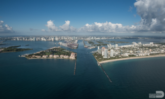
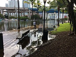
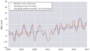
Altimetry enables to monitor sea level in the open ocean - around 3.3 mm/yr globally on average for the past 25 years. However, consequences are most sensitive on the coasts and islands. Miami (where the last Ocean Surface Topography Science Team meeting was held late October 2017) is one of the places where sea level rise can cause a number of damages. The city is very close to the sea, and at a very low altitude, so any above-normal sea level anomaly is threatening part of the city of flooding. High tides, tropical storms and hurricanes, but also changes in the Florida current can cause such anomalies. The land can also be moving - up, or down, as can be measured, e.g. by Doris stations.
Mitigation projects are ongoing by the Miami Dade County to try and avoid the worst of the damages. Dikes, road elevation, mangrove development etc. are under construction or study.If altimetry can't measure at such local scale, the open ocean measurements are giving a trend and values for better estimates or forecasts near to the coasts. WIth SWOT, high resolution coastal measurements will be provided by the satellite, thus providing the sea level variations directly.
See also:
- Mean Sea Level indicator
- Image of the Month,February 2016: Thule Doris station's rising at different velocities
- Image of the Month, October 2009: Dumont d'Urville movements measured by Doris
- Calval: In situ global statistics - Tide gauges
Websites on this subject:
- Mapping of sea level depending on scenarios for Miami
- International Doris Service (IDS) including interactive Tools to plot Doris locations time series
References:
- K. Hagemann, Sea level rise impacts to Miami Dade County, OSTST meeting 2017, Miami, USA
- R. Domingues, G. Goni, M. Baringer, D. Volkov, Evidence of coastal sea level changes along the east coast of United States associated with the Florida Current transport and heat content using satellite altimetry and hydrographic observations, , OSTST meeting 2017, Miami, USA
News
 Archives .
- Aviso Newsletter .
- Search.
- Front-page news.
- Image of the month .
- 2026 .
- 2025 .
- 2024 .
- 2023 .
- 2022 .
- 2021 .
- 2020 .
- 2019 .
- 2018 .
- 2017 .
- Dec. 2017: Sea Level Rise impacts on Miami.
- Nov. 2017: Tracking water bodies.
- Oct. 2017: Plate tectonics.
- Sep. 2017: 25 years, and many more to come.
- Aug. 2017: Waves & currents.
- Jul. 2017: Higher resolution knowledge of flooded areas over the whole Earth.
- Jun. 2017: Eddies everywhere.
- May 2017: Ocean mirrors the deep.
- Apr. 2017: How El Niño and related sea level fall impacted indonesian corals.
- Mar. 2017: Satellites see the highs and lows of the biggest lake in China.
- Feb. 2017: Tidal currents make a buoy's path spiral.
- Jan. 2017: Wave model with ice.
- 2016 .
- 2015 .
- 2014 .
- 2013 .
- 2012 .
- 2011 .
- 2010 .
- 2009 .
- 2008 .
- 2007 .
- 2006 .
- 2005 .
- 2004 .
- 2003 .
- 2002 .
- 2001 .
- 2000 .
- 1999 .
- 1998 .
- Operational news and status .