


News
27.05.2020 13:35 Age: 6 yrs
Survey on visualization tools
Category: Events
OceanDataLab launches a survey to improve its visualization tools.
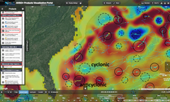
AVISO+ users are already familiar with the Aviso'VIZ interface, developed by OceanDataLab with the support of CNES to visualize a wide range of altimetry products.
Until June 15, 2020 and on the basis of about twenty questions, OceanDataLab launches a survey to improve its visualization tools and build with its user community a set of tools able to exploit all the richness of information from ocean measurements in satellite, model and in situ data.
Access to the survey on the OceanDataLab website: https://odl.bzh/ovl-survey
Further information
- Poster at the EGU 2020 with some examples


