News
Sentinel-6B, keeping an eye on the oceans for climate monitoring
Successfully launched on November 17, the Sentinel-6B mission will track sea level rise, a key indicator of climate change.

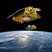
Artist's view of the Sentinel-6 program satellites © CNES/ill./DUCROS David, 2016

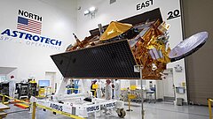
Sentinel-6B during launch campaign on Vandenberg Space Force Base. © USSF 30th Space Wing

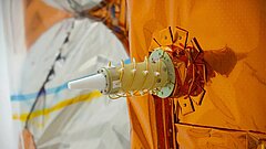
Doris instrument onboard Cryosat 2 satellite. © ESA/CORVAJA Stéphane, 2009

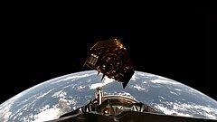
© Nasa, 2025
As sea level rises at an accelerating rate, averaging +4 mm per year over the last decade, the second Sentinel-6 altimetry satellite is going into service to ensure continuity of measurements until 2030. Dedicated to measuring sea level rise and developed jointly by ESA, Eumetsat, and Nasa, with support from Cnes, Sentinel-6B was launched on November 16 at 9:21 p.m. local time from Vandenberg Space Force Base (California, USA).
Part of the European Copernicus program, this operational mission ensures the continuity and stability of measurements which are essential to the climate series initiated by the US-French Topex/Poseidon mission in 1992, then continued by the Jason satellites and more recently by Sentinel-6A Michael Freilich in 2020.
The satellite carries a payload consisting mainly of a radar altimeter, a microwave radiometer, and a satellite positioning system including three different instruments. These four systems enable it to provide us with valuable data on the oceans: by measuring the time elapsed between the emission, the reflection on the ocean, and the reception of the radar signal, it is possible to deduce the height of the water surface. To do this, the satellite also measures the water vapor content of the atmosphere, while engineers on the ground determine its position with great precision (to within a centimeter!) using the positionning system (GNSS, Doris and the laser reflector).
Doris, an essential ally for the mission
To ensure long-term measurement stability and reduce the uncertainty of sea level measurements by between 0.1 and 0.3 mm/year over 10 years, the GNSS system is combined with the Doris (Doppler Orbitography and Radiopositioning Integrated by Satellite) system, developed by Cnes. Used on numerous missions since the 1990s, this system, consisting of a global network of more than 60 ground beacons, is an unfailing ally for altimetry missions. Without precise knowledge of the satellite's position, provided by the GNSS/Doris combination, it is impossible to determine the distance traveled by the radar signal between the ocean surface and the satellite.
"In addition to improving the stability of the orbit solution and enabling the quantification of its uncertainty, which is essential for climate activities, the Doris instrument is also used to provide the satellite with a priori knowledge of its location on board. This information, combined with a digital terrain model loaded on board, enables the Poseidon-4 altimeter to know when it can expect to receive the return signal that we want to measure. This is essential for coastal oceanography, hydrology, and continental ice measurement, where the topography varies rapidly. Without this capability, we would have virtually no data in these important geographical areas. This is one of the key areas of expertise that CNES brings to the program. " (Lionel Zawadzki, Sentinel-6B project manager at Cnes)
Anticipating the impacts of sea level rise
To carry out its mission, Sentinel-6B orbits at an altitude of 1,336 km and an inclination of 66 degrees, enabling it to observe 90% of the ice-free ocean surface. In addition to sea surface heights, it provides near real-time information on significant wave heights and surface wind speeds. The satellite will also provide more detailed data on water eleveations near coasts, sea ice, and continental ice, thanks to advances in radar altimetry techniques developed during the Sentinel-3 and CryoSat missions.
This essential data, combined with data from the entire altimetry constellation, will provide a better understanding of local dynamics and enable us to anticipate the impacts of sea level rise on populations and territories. In France alone, more than 6.4 million people live near the coast and depend directly on the maritime economy, tourism, or coastal resources. However, between 1993 and 2025 altimetry satellites revealed an average rise in sea levels of more than 10 cm... This phenomenon, caused by the melting of glaciers in Antarctica and Greenland, as well as by the thermal expansion of the oceans linked to their warming, has a direct impact on maritime activities and the coastline, where coastal erosion is becoming increasingly visible.
The role of Cnes in the Sentinel-6 program
With over 30 years of expertise in space altimetry missions thanks to the Topex/Poseidon mission, followed by the Jason series of satellites and, more recently, Sentinel-6A Michael Freilich, Cnes supports the entire program, from the development phases to data exploitation, in order to guarantee the highest level of performance and quality of the data produced: system expertise during the development phase, R&D in algorithms and science, operational production of orbit solutions and geophysical corrections, definition of the onboard digital terrain model, analysis of the altimetry system's performance during the CalVal phase and then during the operational phase, operational production of L2P/L3 products for Copernicus core services, etc.
Launch replay:
https://www.youtube.com/@NASA


