


GNSS altimetry
One approach being pursued for achieving maximum altimetry data coverage is to receive reflected signals transmitted by satellites in the Global Navigation Satellite System (GNSS), in particular from the Global Positioning System (GPS) constellation and its future European civil counterpart, Galileo. This concept is based on a satellite on a low-earth orbit (at an altitude of 400 to 500 km) retrieving signals emitted by multiple satellites and reflected by the ocean surface, then analysing these signals to compute sea surface height. The concept is currently still only in the study phase.
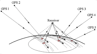
The concept works as follows: a spaceborne GPS receiver receives a signal downlinked from a satellite in the constellation, then receives the return echo of the same signal reflected by the ocean surface. By measuring the delay between the two, we can calculate the sea surface height. The backscatter depends on the angle of incidence - the receiver only senses specular reflection - and on sea surface roughness. Consequently, the system only works well at low angles of incidence up to 10 degrees. Therefore signal returns will only be strong for GPS satellites 'above' the receiving satellite, which will number no more than ten at any one time. In fact, several return echoes above the same area on the ocean will have to be averaged (from 1 to 10 degrees) to reduce the noise. The main weakness of this concept is its accuracy: at an angle of incidence of 10 degrees, the sea surface height error would be several metres. The only way to improve accuracy would be to retrieve more return echoes from the same point on the ocean surface. That would depend on the number of satellites in the GNSS constellation, and the GPS constellation is not expected to expand significantly. On the other hand, the European Space Agency is developing its own GNSS, called Galileo, which could add to the system in the years ahead. The highest accuracy at any given time would be 30 centimetres rms.
Simulations show that a single satellite receiving GPS signals, orbiting at an altitude of 400 kilometres, would cover the globe in 24 hours with a ground track spacing of 75 kilometres. In other words, the satellite would 'see' any given cell of 50 km² on the Earth's surface 12 times in 10 days. On this basis, two satellites providing global coverage would make it possible to achieve sea surface height accuracy of 6 cm rms over an average of 10 days and at a resolution of 50 km². Eight satellites would offer the same level of accuracy, but at a resolution of 25 km².
The major advantage of this mission of opportunity concept is its low cost. Its main drawback is its accuracy, which only Galileo (or Glonass, the Russian satellite navigation system) could increase. It would complement conventional altimetry missions, which are still needed to track climatic variations over the oceans.
Fixed-location GPS receivers could also be installed along coastlines, for example on masts at a height of 200 metres, to deploy a high-quality network that would complement the ocean coverage provided by satellites carrying GPS receivers.
This concept has already been tested on the US Space Shuttle. It is currently flying on the Champ satellite, but no data have been analysed yet. Proposals have been submitted to NASA and ESA for missions that could fly starting in 2010. Another test has also been carried out by UK-DMC (the United Kingdom Disaster Monitoring Constellation), which proved the feasibility of the concept. However, the signal-to-noise ratio is too low for altimetry applications.