


Jason-1, Jason-2 and Envisat GDR 2012 validation
The validation activities performed on Jason-1, Jason-2 and Envisat GDR 2012 data are synthesized in 3 reports (see systematic validation web page). They assess the altimeter data quality: missing and edited measurements, relevant parameters derived from instrumental measurements and geophysical corrections. Analyses are also focused on cross-calibration to precisely assess parameter discrepancies between missions in order to detect geographically correlated biases, jumps or drifts.
For the first time this year, all the Geophysical Data Record (GDR) Jason-2 products were reprocessed on the whole time series. The comparison between the previous GDR data set (GDR-T) and the new one (GDR-D) are detailed in a dedicated document (see dedicated Jason-2 reprocessing web page).
After two successive safe hold mode events in february and march 2012, Jason-1 was manoeuvered into a geodetic orbit in April and May 2012.
The Envisat mission ended on April 8, 2012. In spite of efforts to resume contact with the satellite, the end of the missions operations was declared by European Space Agency on the May 9, 2012. Then 10 years of data are available, with a very good quality and availability and provided to users. These data are also homogeneous and allows to improve the computation of Envisat MSL. This year V2.1 reprocessed dataset was enhanced on several aspects. Last year studies had evidenced some perfectible aspects (lien vers rapport retraitement et bilan annuel 2011) which are actually solved this year. The V2.1+ dataset was upgraded with four corrections:
- PTR with an impact on Global Mean Sea Level (see 2011 annual report and Ollivier et al., 2012);
- POE standard with an impact on Regional Mean Sea Level (see 2011 annual report and Ollivier et al., 2012);
- Radiometer wet tropospheric correction with an impact on performances at crossovers
- Sea State Bias with an impact on performances at crossovers and on mean of SLA
Jason-1 new geodetic orbit:
| Since May 2012, Jason-1 has been moved on a geodetic orbit after more than 10 years on a repetitive orbit. This induces few differences to be taken into account in the products: from cycle 500 onwards, the ground-track drifts and the orbit standard has switched to POE standard D and the mean sea surface available in the GDRs is CNES-CLS-2011. | 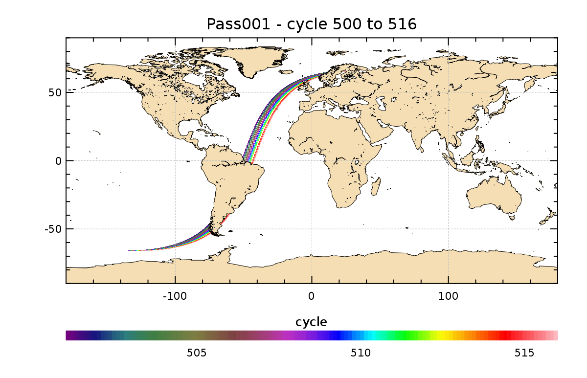 | |
Evolution of the Jason-1 ground track of pass 001 for cycles 500 to 516. Credits CNES/CLS. |
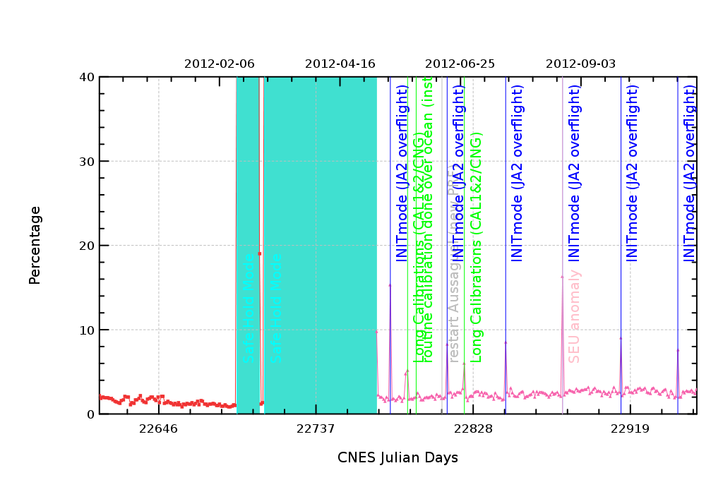 | Because of Jason-2 overflights every 33 days, Jason-1 altimeter does not transmit and is in INIT mode (about 3 hours) (in blue lines), since the beginning of the geodetic orbit (after the light blue area). | |
Jason-1 percentage of missing measurements over year 2012. The INIT mode is in blue line. Credits CNES/CLS |
Performances at crossovers
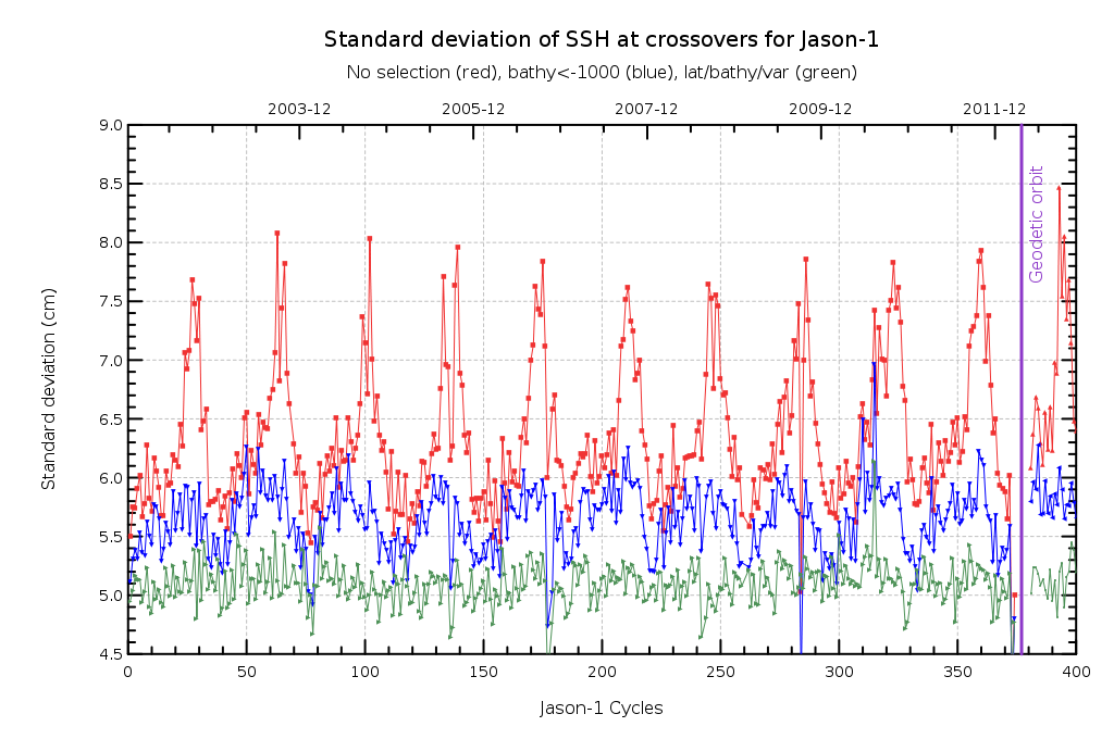 |  | The SLA for Jason-1 performance is very good before and after the move to geodetic orbit | ||
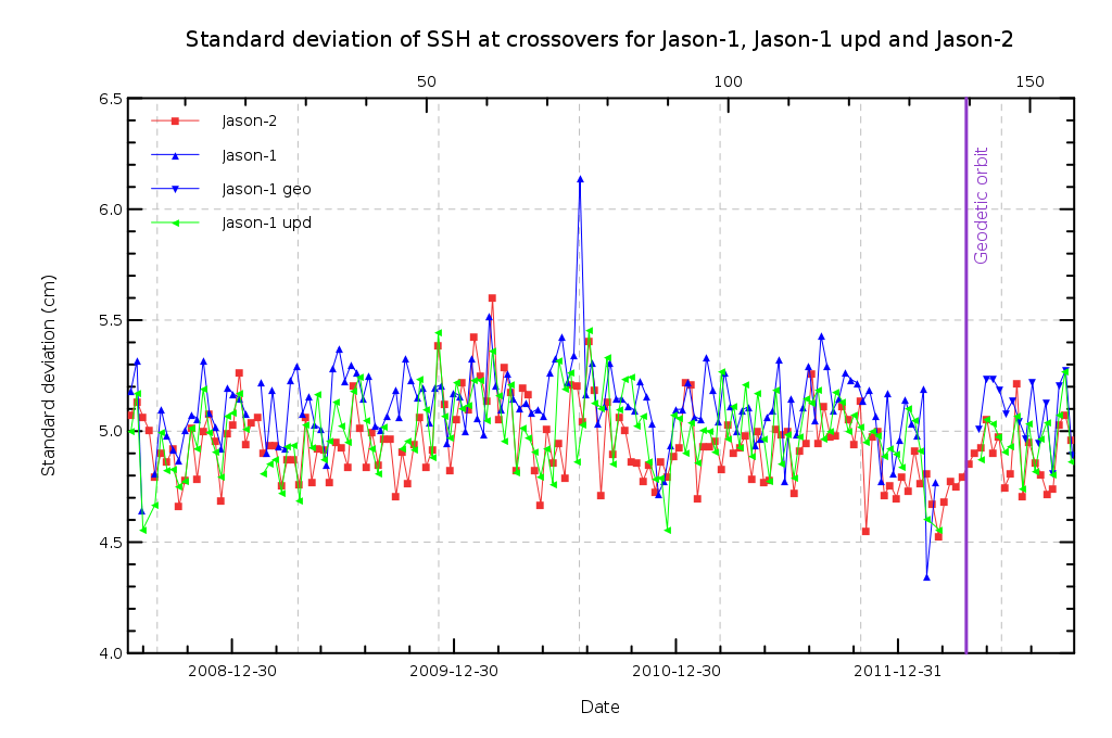
Standard deviation of SSH crossover differences for Jason-1 with no selection (red), with Bathymetry<1000m (blue) and with latitude<50°, Variability<20cm and Bathymetry<1000m (green). Credits CNES/CLS. | Standard deviation of SSH crossover differences for Jason-1 (dark blue: GDR-C data, light blue: updated with POE-D orbit and GOT4V8 tide data) and Jason-2 (red). Credits CNES/CLS. |
| For Envisat, the global impact in terms of performance at crossovers of those four updates (in version 2.1+) is estimated with reference to V2.1 (after reprocessing and distributed to users) and V1 (before reprocessing) respectivelly. | 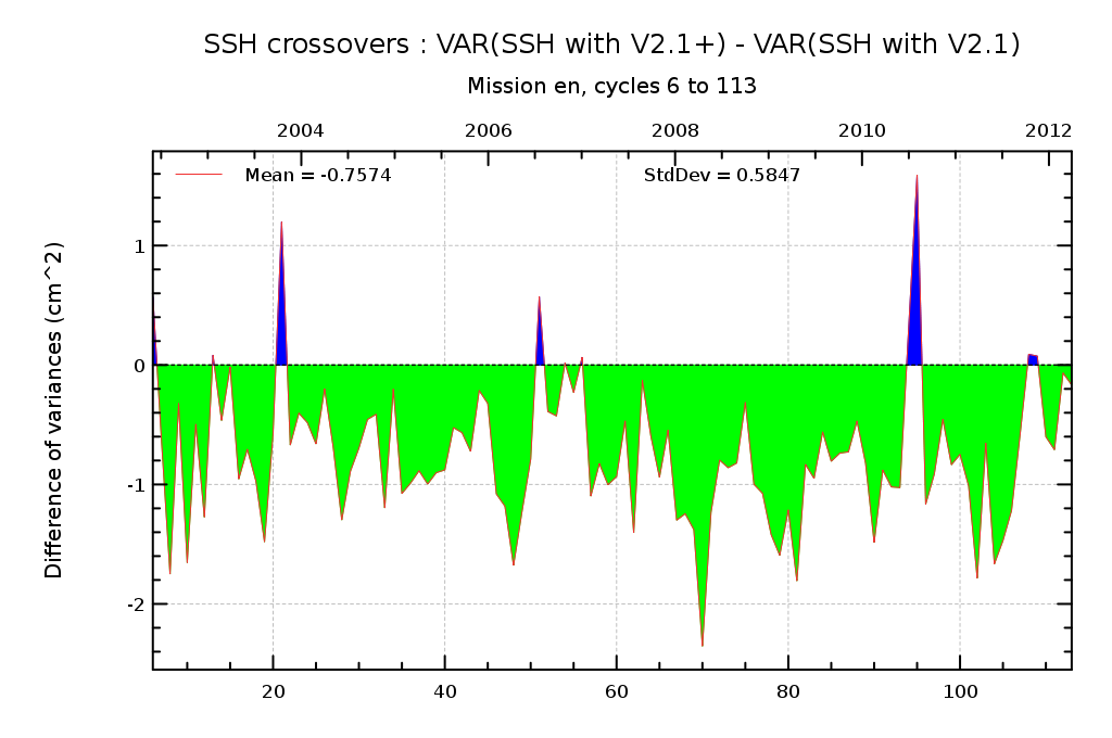 | 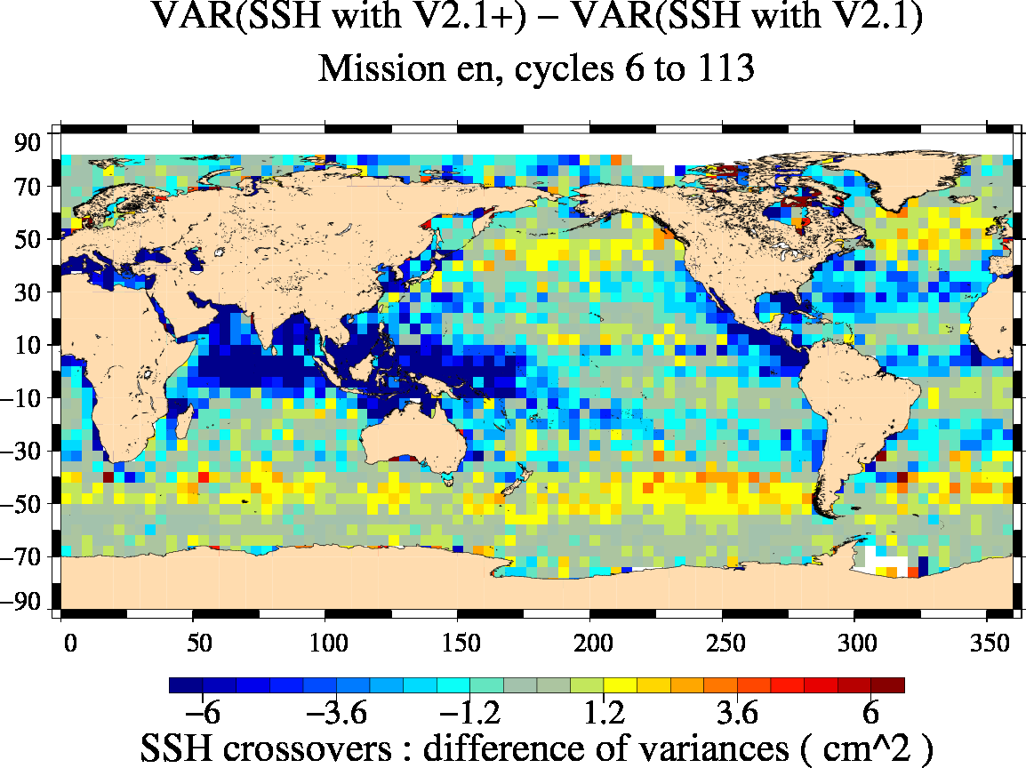 | |
Difference of variance of SSH at crossovers, comparing V2.1+ version (GDR-D orbits, F-PAC PTR, updated wet tropospheric correction to V2.1 version (after reprocessing) | |||
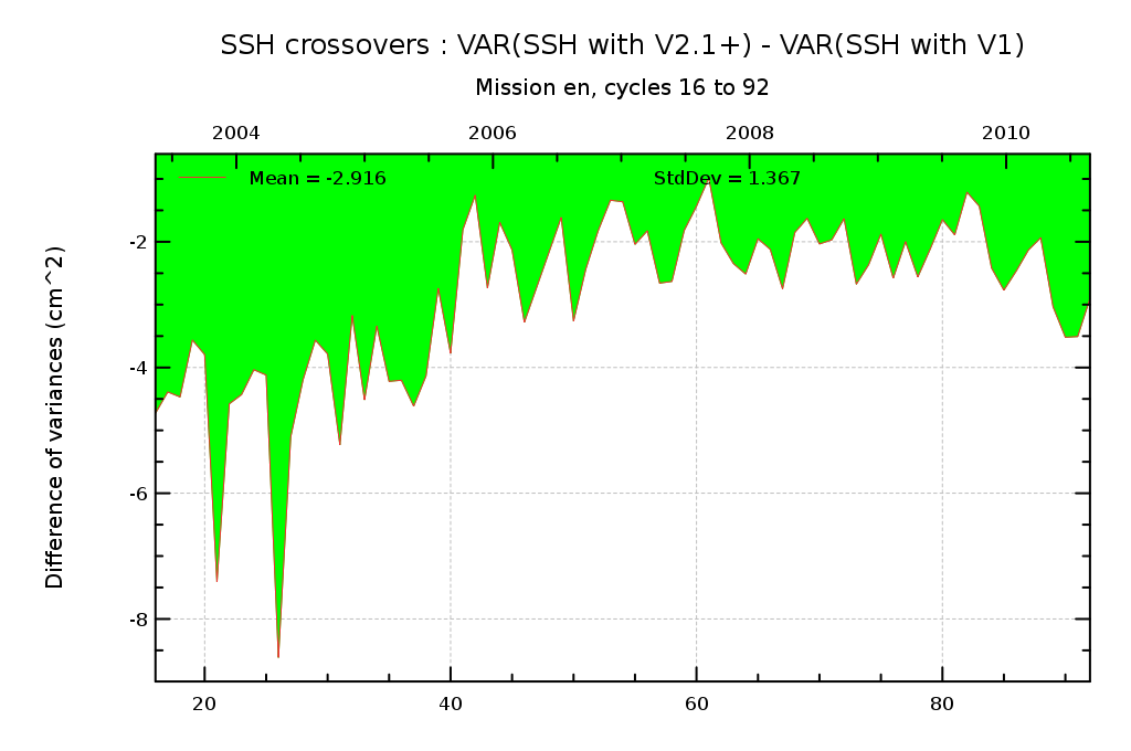 |  | ||
| Difference of variance of SSH at crossovers, comparing V2.1+ version (GDR-D orbits, F-PAC PTR, updated wet tropospheric correction) to V1 version (before reprocessing) | |||
Wet troposphere correction for Jason-1 and Jason-2:
As the wet troposphere correction is a very important variable for mean sea level trend calculation, (radiometer - ECMWF model) wet troposphere correction differences are continously monitored for GDRs as well as for IGDRs.
| For the plot of Jason-1, the yaw manoeuvers are in grey areas and the transition between the repeat orbit and the geodetic orbit is symbolized by the blue area. The difference (radiometer - ECMWF model) was strongly impacted by the yaw maneuvers before its move to geodetic orbit (drop from values below 0.6 cm to values over 0.8 cm), this impact is no more present since the move to geodetic orbit thanks to the use of a new JMR calibration file (visible on IGDRs and GDRs during the two last manoeuvers). | 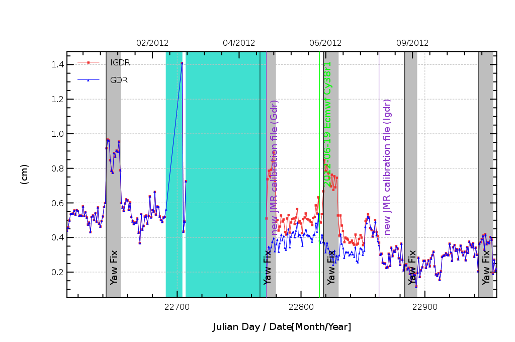 | |
Daily mean of (radiometer - ECMWF model) wet troposphere correction for Jason-1 during 2012. Green line indicate ECMWF model version change, gray stripes indicate periods where Jason-1 is in fix mode. Purple lines indicate new JMR calibration file use for GDR and IGDR computations. Credits CNES/CLS. |
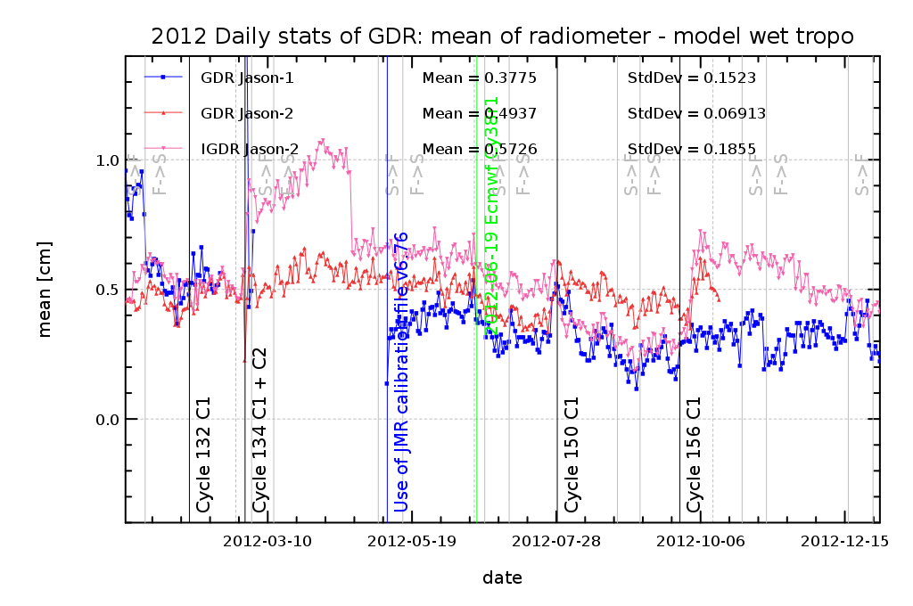 | The Jason-2 radiometer wet troposphere correction is not impacted by the yaw maneuvers. But it is subject (for IGDR data) to drifts and jumps. Thanks to the ARCS system, these problems are mostly corrected in GDR. Nevertheless small jumps persist. | |
Daily monitoring of (radiometer - ECMWF model) wet troposphere correction differences for Jason-2 GDRs (red) and IGDRs (pink), as well as Jason-1 GDRs (blue) for 2012. Vertical green line corresponds to ECMWF model version change, black lines correspond to AMR calibration coeffcients changes on GDR products also impacting IGDR product (but latter). Credits CNES/CLS. |
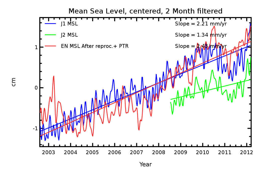
In terms of Mean Sea Level:
The Envisat V2.1+ evolution enables to improve data (see MSL page):
- the effect on global MSL is largely dominated by the PTR evolution (Ollivier et al., 2012) while
- the effect on regional MSL is largely dominated by the POE evolution (Ollivier et al., 2012).
This results in a good consistency between J1 and Envisat on the whole time series. However, multimission and in situ comparisons enabled to evidence some remaining issues, notably on the first year of the Envisat mission, still to be understood.
 |  | |||
MSL computed with latest updates: PTR, updated tropo correction and GDR-D orbits for the period 2003-2012. Credits CNES/ESA/CLS. | (Jason-1 - Envisat) trend differences (mm/yr) after Envisat reprocessing with updates (V2.1+). Credits CNES/ESA/CLS. |
Further information:
- Ollivier A., Y.Faugere, N. Picot, M. Ablain, P. Femenias and J. Benveniste, 2012, Envisat ocean altimeter becoming relevant for Mean Sea Level Trend Studies, Marine Geodesy Vol 35
- Valladeau G, J.-F. Legeais, M. Ablain, S. Guinehut and N. Picot, 2012: "Comparing Altimetry with Tide Gauges and Argo profiling floats for data quality assessment and Mean Sea Level studies. Marine Geodesy, Vol. 35, Iss. sup1.
- Systematic Validation activties
- Jason-1 2012 Annual validation report
- Jason-2 2012 Annual validation report
- Envisat 2012 Annual validation report
- Jason-2 reprocessing report
- Mean Sea Level Rise