


Archives
October 2019 : Finite-Size Lyapunov Exponents (FSLEs) and Orientations of associated eigenvectors: temporal extension of Delayed-Time products
- The Delayed-Time FSLEs are extended until May 2019. Those products are disseminated on ftp as well as on OpenDap and the Data extraction tool. See the product page for complete information and your personal page for the access.
Remind: The FSLEs are computed over 21 years and over global ocean within the SALP/Cnes project in collaboration with CLS, LOcean and CTOH. They provide the exponential rate of separation of particles trajectories initialized nearby and advected by altimetry velocities. They can be used for studies on the ocean variability in different domains of biology, assimilation, societal applications,.... Those high level products are gridded (1/25°), in Delayed-Time and on a routine production with 20-day latency and cover the global ocean.
All the information is given in the Aviso+ product page with a complete description and in the user handbook. Moreover, a dedicated webpage showing examples of use is available.
September 2019: temporal extension of Climatology products (Monthly means)
The Monthly means, Seasonal clim, Monthly clim for Global, mediterranean and black sea (so-called Climatology DUACS2018) have been extended until May 2019.
These products are accessible via your personal page
September 2019: New version of experimental ssalto/duacs products: gridded maps combining altimetry and drifters
A new version (02_00) is available for experimental gridded maps combining altimetry and drifters (see product page and handbook). It takes into account new parameters of the Optimal Interpolation in order to give better comparisons to independent observations. The associated reference paper is:
Mulet S., H. Etienne, M. Ballarotta, Y. Faugere, M.H. Rio, G. Dibarboure, N. Picot, 2019. Synergy between surface drifters and altimetry to increase the accuracy of sea level anomaly and geostrophic current maps in the Gulf of Mexico, accepted for publication in the “25 years of progress in radar altimetry” special issue of Advances in Space Research journal
July 2019: Transition AVISO+ to CMEMS for gridded wave products

The European Copernicus Marine Environment Monitoring Service (CMEMS) is now in charge of the processing and distribution of the gridded L4 wave products. Indeed in the frame of the Transition AVISO+ to CMEMS, AVISO+ focuses on the distribution of innovative products whereas CMEMS is dedicated to the operational products and services.
Since July 2019, gridded L4 wave products (called WAVE_GLO_WAV_L4_SWH_NRT_OBSERVATIONS_014_003) have been added to the CMEMS catalogue.
Therefore the CMEMS catalogue disseminates Near-Real-Time gridded L4 wave products as well as two along-track L3 wave products (altimetry and spectral).
The CMEMS gridded L4 wave products take into account a new processing slightly different from the AVISO+ one fully described in the CMEMS QUality Information Document: QUID with a grid of 2°x2°. You will find the correspondence between the AVISO+ and CMEMS wave products in the document Migration AVISO+ to CMEMS and AVISO+ to C3S (section 8) and a brief overview of the differences in section 8.
Thus, the dissemination of the AVISO+ gridded L4 wave products will stop by the end of the year 2019.
So the user is invited to register to CMEMS as soon as possible: the useful links to CMEMS are indicated in the document Migration AVISO+ to CMEMS and AVISO+ to C3S.
Note that for the moment, the gridded L4 wind products will still be disseminated by AVISO+.
July 2019: temporal extension of Climatology products (Monthly means, Monyhly climatology, Seasonal climatology)
The Monthly means, Seasonal clim, Monthly clim for Global, mediterranean and black sea (so-called Climatology DUACS2018) have been extended until December 2018.
These products are accessible via your personal page
July 2019 : Finite-Size Lyapunov Exponents (FSLEs) and Orientations of associated eigenvectors: temporal extension of Delayed-Time products
- The Delayed-Time FSLEs are extended until January 12th 2019. Those products are disseminated on ftp as well as on OpenDap and the Data extraction tool. See the product page for complete information and your personal page for the access.
Remind: The FSLEs are computed over 21 years and over global ocean within the SALP/Cnes project in collaboration with CLS, LOcean and CTOH. They provide the exponential rate of separation of particles trajectories initialized nearby and advected by altimetry velocities. They can be used for studies on the ocean variability in different domains of biology, assimilation, societal applications,.... Those high level products are gridded (1/25°), in Delayed-Time and on a routine production with 20-day latency and cover the global ocean.
All the information is given in the Aviso+ product page with a complete description and in the user handbook. Moreover, a dedicated webpage showing examples of use is available.
June 2019: temporal extension of Climatology products (Monthly means)
The Monthly means for Global, mediterranean and black sea (so-called Clmitalogy DUACS2018) have been extended until September 2018.
These products are accessible via your personal page
June 2019: Finite-Size Lyapunov Exponents (FSLEs) and Orientations of associated eigenvectors: temporal extension of Delayed-Time products, and new dissemination of Routine products
- The Delayed-Time FSLEs are extended until September 23rd 2018. Those products are disseminated on ftp as well as on OpenDap and the Data extraction tool. See the product page for complete information and your personal page for the access.
- The Routine FSLEs are now available on Opendap and Data extraction tool services. See the product page for complete information and your personal page for the access.
Remind: The FSLEs are computed over 21 years and over global ocean within the SALP/Cnes project in collaboration with CLS, LOcean and CTOH. They provide the exponential rate of separation of particles trajectories initialized nearby and advected by altimetry velocities. They can be used for studies on the ocean variability in different domains of biology, assimilation, societal applications,.... Those high level products are gridded (1/25°), in Delayed-Time and on a routine production with 20-day latency and cover the global ocean.
All the information is given in the Aviso+ product page with a complete description and in the user handbook. Moreover, a dedicated webpage showing examples of use is available.
January 2019: temporal extension of the Delayed-Time Finite-Size Lyapunov Exponents (FSLEs) and Orientations of associated eigenvectors
The Delayed-Time FSLEs are extended to June 10th 2018.
Remind: The FSLEs are computed over 21 years and over global ocean within the SALP/Cnes project in collaboration with CLS, LOcean and CTOH. They provide the exponential rate of separation of particles trajectories initialized nearby and advected by altimetry velocities. They can be used for studies on the ocean variability in different domains of biology, assimilation, societal applications,.... Those high level products are gridded (1/25°), in Delayed-Time and on a routine production with 20-day latency and cover the global ocean.
All the information is given in the Aviso+ product page with a complete description and in the user handbook. Moreover, a dedicated webpage showing examples of use is available. Do not hesitate to send us your feedbacks and papers, we will be pleased to add them in this page.
You will find these new data on the authenticated FTP, Opendap and Data extraction Tool in your personal page
June 2018: Transition AVISO+ to C3S for SSALTO/Duacs products gridded products merging two satellites ('twosat')
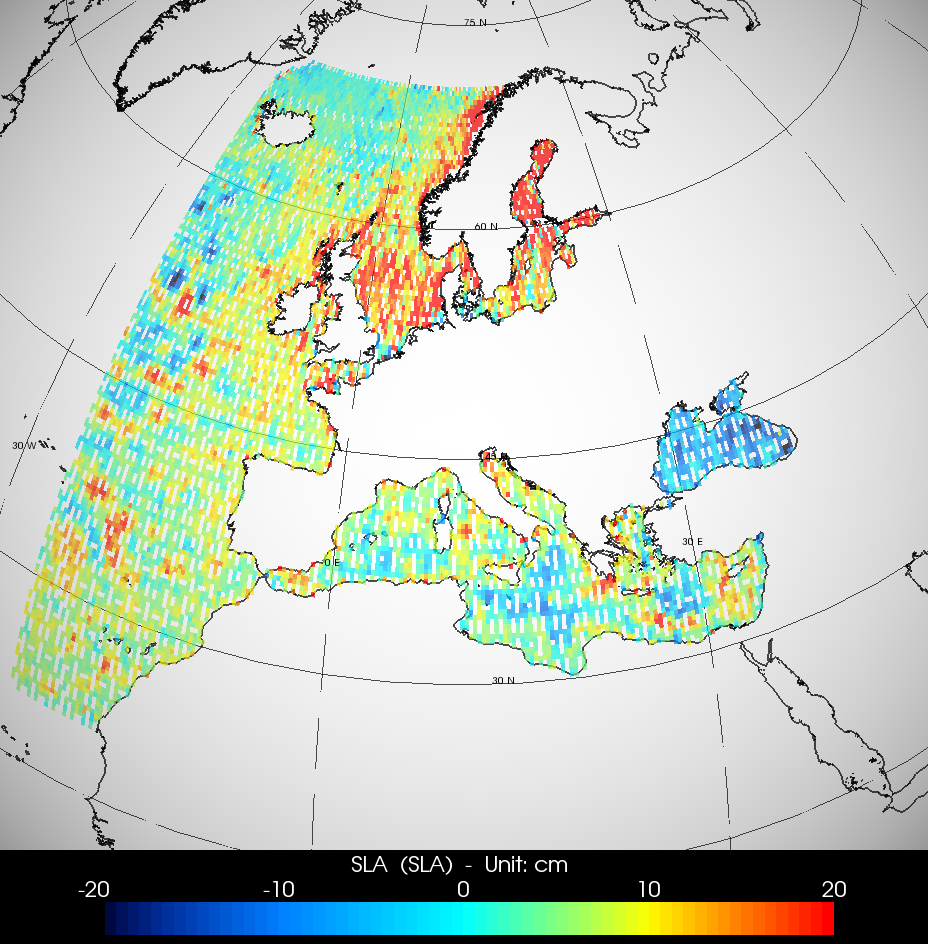
The Copernicus Climate Change Service (https://climate.copernicus.eu/) is now in charge of the processing and distribution of the SSLATO/Duacs "two-sat-merged" Gridded products as there are produced on an operational basis for climate oriented applications. The variables are the Sea Level Anomalies (SLA), the Absolute Dynamic Topography (ADT) and the geostrophic velocities on Global, Mediterranean and Black Seas in Delayed-Time. Compared to previous products disseminated by Aviso+, an upgrade has been done mainly on the standards used in the processing.
May 2017: End of Transition AVISO+ to CMEMS and new CMEMS version since April 19th
The European Copernicus Marine Environment Monitoring Service (CMEMS) is now in charge of the processing and distribution of some altimetry products formely distributed by AVISO+. Indeed AVISO+ now focuses on the distribution of innovative products whereas CMEMS is dedicated to the operational products and services. Since CMEMS Version3 (April 19th, 2017) all the SSALTO/Duacs “all-sat-merged” products ( (M)SLA and (M)ADT Heights and geostrophic velocities (except the Mozambique area and climatologies) ) are disseminated by CMEMS. It is foreseen to stop the production of NRT products on Aviso+ by June 19th, 2017. Please if not already done, register on CMEMS as soon as possible. See below the list of products detailed in the tables with the end date of AVISO+ dissemination when necessary.
What you will find in the AVISO+ reference portal in altimetry:
- All the altimetry products are on the AVISO+ Catalogue (including those disseminated by CMEMS).
- The gridded Sea Level products (MSLA-H, MSLA-UV, MADT-H and MADT-UV) can still be visualized with the Live Access Server (LAS).
- AVISO+ keeps disseminating (see the tables below):
- The Sea Level Anomalies climatologies for Global, Mediterranean Sea and Black Sea.
- The Mozambique SLA-H, MSLA-H and MSLA-UV products with upgrades related to the new version, see below.
- The gridded “two-sat-merged” Delayed-Time series. Note that this dataset is based on only two missions at most; it is mainly for applications in need of great temporal stability; they might not be the best in quality at a given time. In a near future, those products will be disseminated via the Copernicus Climate Change Service (C3S). AVISO+ will then stop the dissemination but will still propose these products in its catalogue.
List of the products concerned by the transition:
Click on the document Migration AVISO+ to CMEMS and C3S to display the hyperlinks for each product
April 19th new version:
The CMEMS version is called V3. The main changes are the following:
- All the variables are delivered in a unique file (sla, adt, currents,… ) with new variable names,
- The file nomenclature has changed,
- New datasets are disseminated: Sentinel-3A (s3a) for NRT series and AltiKa Geodetic orbit called Drifting Phase (alg) , Jason-3 (j3) for REP (=REPROCESSING or Delayed-Time) series,
- The MSS CNES_CLS15 is used instead of DTU13 for Arctic NRT series,
- The extension of the REP series.
The complete description about this new CMEMS version (called V3) is available here, with details about each products in the dedicated CMEMS file where you will also find new files' samples. The altimetry products are referenced by the SEA LEVEL Thematic Assembly Center (SEA LEVEL TAC).
The detailed information about AVISO+ dissemination is given below.
The Nomenclature of the CMEMS products dedicated to altimetry is:
SEALEVEL_<zone>_<variable>_<delay>_OBSERVATIONS_008_<xxx> Where:
- SEALEVEL stands for all SEA LEVEL TAC products
- <zone>=GLO for global coverage, MED for Mediterranean Sea, BS for Black Sea, EUR for European region, ARC for Arctic Ocean
- <variable>=PHY_L3 for SLA and ADT along-track products; PHY_ASSIM_L3 for SLA along-track products dedicated to assimilation; PHY_L4 for SLA, ADT and currents gridded-merged products
- <delay>=NRT for near-real-time, REP for reprocessing (=delayed-time)
- <xxx>= the number attributed to each product
November 2016: integration of Jason-2 interleaved orbit in Ssalto/Duacs and MSS_CNES_CLS15 for Cryosat-2 and AltiKa
As previously announced, the satellite OSTM/Jason-2 has been moved on an interleaved orbit. The orbit maneuvers started on October 2th, at the end of the cycle 303 which is the last OSTM/Jason-2 cycle on the nominal ground track. OSTM/Jason-2 has been slowly moving away from his little brother Jason-3. The final interleaved orbit has been reached on October 14th and the first cycle of measurement is numbered 305.
OSTM/Jason-2 has been reintroduced in the SSALTO/Duacs system on November 24th 2016, after the end of the orbit change maneuvers, increasing the number of altimeters in the constellation.
Conjointly with this reintroduction, there is a change of the Mean Sea Surface (MSS) model involved in the SLA computation along geodetic or drifting orbits (Cryosat-2; SARAL-DP/AltiKa) for which no precise mean profile is available (see Pujol et al (2016) for details). The new MSS_CNES_CLS15, that strongly improves the quality of the SLA on these missions (Schaeffer et al, OSTST, 2016 ; Pujol et al., OSTST, 2016), will be used instead of the previous MSS_CNES_CLS11 version.
Impact for the users:
Now, four altimeters are available, with an additional dataset corresponding to the OSTM/Jason-2 measurement on its interleaved orbit (new dataset j2n for along-track products). The Jason-3/OSTM-Jason-2 interleaved duo is indeed optimized for mesoscale and circulation observation as previously discussed in Dibarboure et al (2011). This improved sampling will contribute to improve the quality of the SLA gridded products (Level4 products).

Note that
- The interleaved orbit is the same as used for Jason-1 during the [mid-February 2009, March 2012] period: the ground track position is midway between its original ground tracks but with a time lag of approximately 5 days with Jason-3. In other words, the start time of the OSTM/Jason-2 and Jason-3 repeat cycles will differ by approximately 5 days.
- The measurement errors of OSTM/Jason-2 on its new orbit are expected to be the same as on its historical repeat orbit (same as for Jason-3).
We remind you that the Sea Level Anomalies Height (except for Mozambique area and climatologies) are now distributed by CMEMS as detailed below.
References:
- Dibarboure, G., Pujol, M.-I., Briol, F., Le Traon, P.-Y., Larnicol, G., Picot, N., Mertz, F., Escudier, P., Ablain, M., and Dufau, C.: Jason-2 in DUACS: first tandem results and impact on processing and products, Mar. Geod., OSTM Jason-2 Calibration/Validation Special Edition – Part 2, 34, 214–241, doi:10.1080/01490419.2011.584826, 2011.
- Pujol M.-I., Y. Faugère, G. Taburet, S. Dupuy, C. Pelloquin, M. Ablain, and N. Picot, DUACS DT2014: the new multi-mission altimeter data set reprocessed over 20 years, Ocean Sci., 12, 1067-1090, doi:10.5194/os-12-1067-2016, 2016
- Schaeffer P., M-I Pujol, Y Faugere, A. Guillot, N. Picot, New Mean Sea Surface CNES_CLS 2015 Focusing on the use of Geodetic Missions of CRYOSAT-2 and JASON-1, Oral presentation OSTST 2016.
- Pujol M-I, G Dibarboure, M Raynal, C Dufau, Y Faugere, A Guillot, N Picot, Mean Sea Surfaces errors characterization, Oral presentation OSTST 2016.
September 2016: integration of Jason-3 as a new reference mission in Ssalto/Duacs
The new mission Jason-3 integrates the Ssalto/Duacs multimission system on September 13, 2016 (please note that this date could be delayed).
By succeeding TOPEX/Poseidon, Jason-1, and OSTM/Jason-2, Jason-3 extends the high precision altimetry data record to support climate monitoring, operational oceanography and seasonal forecasting. Launched in January 17th 2016, Jason-3 is operated by the NOAA in partnership with the NASA, the CNES and EUMETSAT. Jason-3 has the same orbit than the current OSTM/Jason-2 mission, OSTM/Jason-2 will be moved to a new orbit in October (TBC) in order to improve the spatial resolution of gridded products. Note that the integration of Jason-3 in the Sea Level observations data leads to the deactivation of the current OSTM/Jason-2 mission. OSTM/Jason-2 will be reintroduced later when it will reach its interleaved orbit , through a new dataset named "j2n".
On September 13, 2016, the following products are concerned:
• the along-track Absolute Dynamic Topography heights in Near-Real-Time (ADT-H): a new dataset is available (with the same nomenclature/format as other datasets, but with "j3" mission). Thus the OSTM/Jason-2 mission is deactivated (no more "j2" files delivered).
• the gridded products heights and currents in Near-Real-Time (MADT-H, MADT-UV, MSLA-UV): Jason-3 mission turns into the new reference mission and replaces Jason-2 mission in the merged maps.
Note that the global biases between OSTM/Jason-2 and Jason-3 are taken into account in order to minimize the impact of the change, but the East/West biases (mainly induced by orbit differences) will be corrected only in Delayed-Time (Reprocessed) production.
2016: Transition Aviso+ to CMEMS

As already announced, the European Copernicus Marine Environment Monitoring Service (CMEMS, previously known as MyOcean) is now in charge of the processing and distribution of some altimetry products formely distributed by Aviso+. The SSALTO/Duacs (M)SLA heights data (except the Mozambique area and climatologies) are now distributed in their catalogue (the scientific content hasn’t changed). Note that (M)ADT products and currents will be concerned in 2017. Thus they are still distributed by Aviso+.
Consequently, Aviso+ doesn’t distribute any more to new users those products. They were still distributed by Aviso+ for a few months for the users who already download them via Aviso+ with their account. It is planned to close this access in the coming weeks. We remind you to register yourself to CMEMS as soon as possible. Indeed, it is not legally possible for us to transfer your coordinates to CMEMS directly.
The Nomenclature of the CMEMS products dedicated to altimetry is:
SEALEVEL_<zone>_<variable>_<delay>_OBSERVATIONS_008_<xxx> Where:
- SEALEVEL stands for all SEA LEVEL TAC products
- <zone>=GLO for global coverage, MED for Mediterranean Sea, BS for Black Sea, EUR for European region, ARC for Arctic Ocean
- <variable>=SLA_L3 for SLA along-track products; SLA_ASSIM_L3 for SLA along-track products dedicated to assimilation; SLA_MAP_L4 for SLA gridded-merged products
(note that for the moment only SLA heights are distributed by CMEMS. The ADT heights and SLA and ADT currents products will be concerned during year 2017) - <delay>=NRT for near-real-time, REP for reprocessing (=delayed-time)
- <xxx>= the number attributed to each product
List of the products concerned
Download the pdf here to display the hyperlinks for each product on CMEMS website:
All the CMEMS links are listed hereafter:
- For questions regarding the (M)SLA-H products, please contact: servicedesk.cmems(at)mercator-ocean.eu
Please, concerning the another products (M)ADT-H and UV geostrophic velocities, contact aviso@altimetry.fr - Online catalogue of all the CMEMS products
- Registration to get access to products
- Service commitments and Licence
- Handbooks associated to the (M)SLA-H products distributed by CMEMS and Handbook SLA for assimilation (not distributed by Aviso+)
The CMEMS diffusion services are:
- A ftp server
- A DirectGetFile server (DGF) which concatenates files for a period of time
- A Subsetter server which extract gridded-merged files on a period of time and over a region (it is the same tool as the Gridded Extraction Service on Aviso+)
- A WMS server which allows the visualization of a dataset
June 2015: Implementation of the Saral/AltiKa orbit drift
Due to reaction wheel issues, SARAL station keeping maneuvers have not been performed nominally since March 31st, 2015. As a result, SARAL/AltiKa’s ground track has been drifting from the nominal track with deviations overtaking 10km depending on the latitude, instead of ±1km usually. This drift has an impact on the SSALTO/Duacs AL product. Indeed, SARAL/AltiKa is currently processed as a repetitive mission (like Jason-2). This processing includes the projection of the measurement into a theoretical track position in order to benefit from the precise Mean Profile estimated from past missions (ERS1/2, Envisat). However, as the distance between the theoretical track and the true track position is now large, this projection processing induces an additional error in the product. Since mid may 2015, we indeed observe an increase of the variability of the SARAL/AltiKa SLA at short wavelengths (< ~200km).
In order to limit the degradation of the quality of the product, the SARAL/AltiKa mission is now processed as a geodetic mission, i.e. avoiding projection on a theoretical track, as currently done for Cryosat-2 or HY-2A processing. This implies xxxxxxxxxxxxxxxxxxx
- that the measurement positions will change from one cycle to another one.
- Moreover, a short wavelength error will be induced on the raw SARAL/AltiKa measurement, due to the use of a gridded Mean Sea Surface solution rather than a more precise Mean Profile for SLA computation. However, the processing includes an along-track filtering that strongly reduces this error signature on filtered products.
The processing change in the SSALTO/Duacs system has been implemented from day June 30th 2015 onwards.
May 2015: New GDR-E orbit standards on Jason-2
Status on the altimetric orbit standards
Since July 2012, the orbit [I]GDR standard used is version “D” or equivalent, both in Near Real Time (NRT) and Delayed Time (DT) measurements. The spatial agencies have planned to switch to a new orbit standard version "E" for the different missions and especially on Jason-2 on May 26th (see the dedicated webpage). Only the orbit parameter will change (altitude), the other parameters will remain unchanged and stay at the current altimetric standard version "D".
This change includes the implementation of a reduced-dynamic parameterization and improved Solar Radiation Pressure (SRP) models, the use of an improved gravity model, a better definition of the geocenter position among others. It will improve the satellite position determination, and thus the altimeter sea surface height measurement.
As long as Cryosat-2 and AltiKa are secondary missions, calibrated on Jason-2 reference mission, the orbit standard change for these missions has no significant impact on the product quality. It is not the case for the Jason-2 Orbit standard change as discussed below.
Impact of the Jason-2 orbit standard change for SSALTO/Duacs products
The differences between orbit versions “D” and “E” (Table 1) have an impact in terms of global and regional biases. SSALTO/Duacs processing will ensure a transition as seamless as possible between the orbit standards in order to minimize the impact of this change on Jason-2 Sea Level Anomaly products. However, this change may affect Jason-2 and the other altimeters products since Jason-2 is the reference mission used for the altimeter inter-calibration processing in the system.
The impact of the orbit standards change was estimated in Delayed Time conditions (i.e. reprocessed GDR), over the entire Jason-2 series:
Before SSALTO/Duacs processing, difference between SLA with GDR-D and GDR-E standards shows a mean global bias of less than 2 mm (GDR-D – GDR-E). As this bias is of the same order than the MOE orbit temporal variability, no modification of the SSALTO/Duacs system will be done in NRT conditions to absorb this bias. The SSALTO/Duacs processing, including the intercalibration/homogenization processing (i.e. Orbit Error reduction and Long Wavelength error correction), will ensure a seamless transition. The global mean bias will be corrected by SSALTO/Duacs system in DT conditions. No impact is thus expected in terms of global Mean Sea Level in DT.
Differences between SLA with GDR-D and GDR-E standards also reveal a geographical variability at regional scales (i.e. basin to hemispheric scales). The regional differences range nearly by ±5 mm before SL-TAC processing (see Figure 1). These regional biases will be corrected in DT processing in order to minimize the impact in terms of regional Mean Sea Level.
However, they also present an important temporal variability that makes it difficult to accurately estimate them in Real Time conditions. As a consequence, no specific change will be done in the NRT SSALTO/Duacs system to correct the regional bias induced by the altimeter standards. Here again, the intercalibration/homogenization processing will allow a minimization and a progressive introduction of the regional bias into the NRT products.
| Parameter | GdrE main changes | Impact after SSALTO/Duacs processing | |
|---|---|---|---|
| NRT conditions | DT conditions | ||
| Orbit |
| Mean : <~2 mm expected progressively introduced Regional impact : < ±5mm progressively introduced | Mean : ~0 mm Regional impact : ~0 mm |
Table 1: Impacts of the differences between GDR-D and GDR-E Jason-2 altimeter orbit standards, estimated in delayed time conditions, over a 7 months period.
 |
Figure 1: Regional biases observed between GDR-E and GDR-D Jason-2 orbit over cycle 1 to 224 (DT POE orbit). Credits Cnes/CLS. |
February 2015: New Ssalto/Duacs Version V15.3: upgrade of the processing chain on the editing process
The processing chain has been modified (V15.3) in order to take into account the following changes. The product impact is slight.
1/ the editing thresholds on Sea Level Anomalies (SLA) in order to take into account the evolution of the Mea Sea Level trend.
2/ the editing threshold on the Saral/AltiKa mispointing:
During the past months (October 2014), a mispointing issue was detected on AltiKa measurements. Mispointing data are detected as out of thresholds. As a consequence, the issue on thresholds applied on mispointing values has been addressed. After investigations, experts requirement is a maximum limit for mispointing fixed to 0.0625 deg2 instead of 0.16 deg2 currently used in SSALTO/Duacs system. The figure below presents on the left the mispointing behaviour (in red, axes on the left) and valid SLA (in blue and green, axis on the right) during such an event. The horizontal red line indicates the threshold used for valid mispointing data. We easily see that the used threshold seems to be too lax, spurious points of SLA are considered as valid but clearly degrade statistics. On the right the new solution with a more strict threshold applied on mispointing is shown. We can see in green SLA values considered as valid in this case. Statistics on SLA notably standard deviation is here really
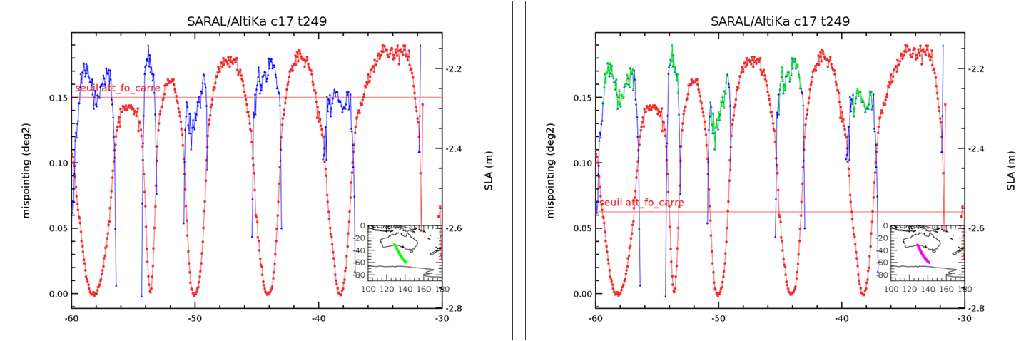 |
Behaviour of mispoiting values (in red) and valid SLA (in blue/green) |
November 2014: Temporal extension up to 2014/05/30 of Ssalto/Duacs delayed time products
Delayed-Time products have been extended up to 2014/05/30. Moreover HY-2A mission has been added. This concerns along-track (missions Saral/AltiKa, Jason-2, Cryosat-2, HY-2A) and gridded products. Note that this update only concerns the new version DUACS 2014 of products.
The products are available via:
- the ftp server (ftp.aviso.altimetry.fr) with your personal login/password for along-track and gridded products in the following folders:
- <zone>/delayed-time/along-track/<filtering>/<variable>/<mission>/2014
- <zone>/delayed-time/grids/m<variable>/<nbsat>/<field>/2014
- <zone>/delayed-time/grids/climatology/monthly_mean
where
<zone>=global or regional-mediterranean or regional-blacksea
<filtering>=filtered or unfiltered
<variable>=sla or adt
<nbsat>=all-sat-merged or two-sat-merged
<mission>=al or j2 or h2 or c2
<field>=h or uv
- the extraction tools for gridded products:
- Opendap, with generic login/password
- Gridded data extration tools with personal login/password
- the Live Access Server to vizualise data (only for gridded products, no authentication).
September 2014: Temporal extension up to May 1st, 2014 of Ssalto/Duacs delayed time products
Delayed-Time products have been extended up to May 1st, 2014. This concerns along-track (missions Saral/AltiKa, Jason-2, Cryosat-2) and gridded products. Note that this update only concerns the new version DUACS 2014 of products and permits to fill in the data gaps between Delayed-Time (January 1993 - May 2014) and Near-Real Time (April 2014 - today) series.
They are available via:
- the ftp server (ftp.aviso.altimetry.fr) with your login/password for along-track and gridded products in the following folders:
- <zone>/delayed-time/along-track/<filtering>/<variable>/<mission>/2014
- <zone>/delayed-time/grids/m<variable>/<nbsat>/<field>/2014
- <zone>/delayed-time/grids/climatology
where
<zone>=global or regional-mediterranean or regional-blacksea
<filtering>=filtered or unfiltered
<variable>=sla or adt
<nbsat>=all-sat-merged or two-sat-merged
<mission>=al or j2 or or c2<br/><field>=h or uv
- the extraction tools (Opendap, Gridded data extration tools) with generic login/password for gridded products.
- the Live Access Server to vizualise data (only for gridded products).
September 2014: New Ssalto/Duacs Version V15.2: Minor changes
The Duacs V15.2 version has been installed: upgrade of softwares with no impact on products.
May 2014: Integration of HY-2A in Duacs
We are pleased to announce the integration of HY-2A in the Duacs v15.1 multimission near-real time system.
The HY-2A integration contributes to improve the sea surface sampling, and thus the reconstruction of the mesoscale structures, particularly in the regions of strong ocean activity.
CONTEXT
HY-2A is the first altimetric and radiometric satellite launched in August 2011 by the China National Space Administration (CNSA) with a CNES collaboration, and dedicated to oceanography.
Thanks to the strong cooperation between NSOAS (which is in charge of the exploitation of HY-2A) and CNES, a new processing prototype (HPP) was developped to introduce HY-2A intercalibrated data into Ssalto/Duacs system .
PRODUCTS CONCERNED
The integration of HY-2A in the Duacs V15.1 impacts the delivering of Near Real Time Level-3 (along-track) and Level-4 (grids) products (height, formal mapping error and geostrophic currents). The directories concerned on the ftp server are :
- /**region**/near-real-time/along-track/filtered/sla/h2
- /**region**/near-real-time/along-track/filtered/adt/h2
- /**region**/near-real-time/grids/msla/all-sat-merged
- /**region**/near-real-time/grids/madt/all-sat-merged
The integration of the HY-2A is not included in the Duacs v14.0.1. We remind that this Duacs V14.0.1 is the former Duacs version with a seven-year reference period, only distributed up to mid-June 2014.
This new Duacs V15.1 with the integration of HY-2A also includes the new 20-year reference period. So, we encourage users to take advantage of the new HY-2A in the Duacs V15.1 to make the necessary changes to the system to accommodate the new 20-year reference period.
The processing in the Duacs multi-mission system for HY-2A is only based on IGDR data flows (no OGDR), and is the same as for other satellites, the corrections used are indicated in the <link file:2217 hdbk>handbook.
All HY-2A products over oceans, from Cnes's HPP are generated on a best effort basis.
BENEFITS
Thanks to these adapted HPP evolutions, HY-2A provides valuable information on the ocean mesoscale variability.
This integration contributes to improve the sea surface sampling, and thus the reconstruction of the shape, size and intensity of the mesoscale structures, particularly in the regions of strong ocean activity.
Moreover, HY-2A complements the sampling of current missions (Jason-2, AltiKa and Cryosat-2) and thus, reinforces the resilience of the system.
With the integration of HY-2A into the system, the constellation now used is a 4-altimeter constellation. The contribution of HY-2A to a gridded merged products is about 18%, i.e. nearly the same than Cryosat-2 (20%), while Jason-2 and AltiKa contribute for 32 and 30% respectively.
Further information:
- OSTST 2013, N.Picot et al.: Towards an Operational Use of HY-2A in Ssalto/Duacs: Evaluation of the Altimeter Performances Using NSOAS S-IGDR Data (pdf
March 2014: Information about DUACS 2014 products changes and updates
On April 15th, 2014, a new version of the SSALTO/Duacs products distributed by Aviso, so-called DUACS 2014, will be released with several significant upgrades. The whole range of products, in near real time and delayed time, along track and gridded, will be impacted in terms of scientific content, format and naming. A complete reprocessing of the whole altimeter time series has also been performed. These evolutions have strong impacts and will necessitate actions on the user’s side.
These changes contribute to improve the product quality but also to better fit the users’ needs. They mainly concern:
- The change of the reference period: in the DUACS 2014 version, the reference period of the Sea Level Anomalies is based on a 20-year [1993, 2012] period whereas in the former version it is on a 7-year [1993, 1999] period.
- The change of the SLA bias: the general convention to the bias applied to all of the SSALTO/DUACS SLA products consists of having a mean SLA null over the year 1993.
- The evolution of the gridded product resolution and formats: a new Cartesian ¼° resolution is used instead of the 1/3° Mercator grid and a new NetCDF format with new variables is used.
- The evolution of the along track products geophysical content: a new processing is applied in terms of filtering and sub-sampling, inducing less smoothing notably at low latitudes and a denser dataset.
- In addition to these 4 main changes, several other scientific upgrades are applied.
IMPORTANT NOTICE: the major upgrades of DUACS 2014 products, which are summarised in the table below, will have a strong impact and will necessitate actions on the user’s side. We encourage all SSALTO/Duacs users to carefully read the technical note which describes and explains these evolutions.
To insure a smooth transition between the current products and the DUACS 2014 products:
- samples of DUACS 2014 products are already available in the dedicated operational ftp folders.
- a double ftp dissemination is planned: the two versions of the products will be maintained up to mid June.
The ftp access is already possible with the same personal username/password that you already have. Note that the ftp server has a new name since we changed by Aviso+ website: ftp.aviso.altimetry.fr (the former one: ftp.aviso.oceanobs.com is still working).
For any questions, please contact Aviso User Services: aviso(at)altimetry.fr
| DUACS DT 2010 version no more delivered | DUACS 2014 version from April 15, 2014 onwards | |
|---|---|---|
| Reference period for SLA (grid and along-track) | 7-year period [1993, 1999] | 20-year period [1993, 2012] |
| SLA bias convention | - | Mean SLA null over the year 1993 |
| Spatial grid resolution and projection for the global product | 1/3° Mercator | 1/4° Cartesian with new grid points convention |
| Temporal grid resolution | Daily maps in NRT Weekly maps in DT | Daily maps in NRT and DT |
| Grid definition | Latitude range for global product = [-82,82°N] Longitude range for Mediterranean product= [355,396°E] | Latitude range for Global product= [-89.875,89.875°N] Longitude range for Mediterranean product =[354.0625, 396.9375°E] |
| Grid NetCDF Standard | NetCDF 3 Non CF | NetCDF 3-CF, with new variables and attributes |
| Along track filtering for the Global product | Low pass filtered with a cut-off wavelength between 65km and 250km depending on the latitude | Low pass filtered with a cut-off wavelength of 65km for the whole globe |
| Along track sub-sampling for the global product | 1 point kept over 3 to 7 points depending on the latitude | 1 point kept over 2 points for the whole globe |
| Folders and file naming on ftp.aviso.altimetry.fr server | The Near Real Time and Delayed time product are respectively in the “nrt” and “dt” folders | The Near Real Time and Delayed time product are respectively in the “near-real-time” and “delayed-time” folders and file nomenclature has changed |
Further information:
- Technical Note: A new version of SSALTO/Duacs products available in April 2014
- Newsletter #9 (April 2013): Change of the Ssalto/Duacs reference period (p3)
Dec 2013: Temporal extension up to August 7, 2013 of Ssalto/Duacs delayed time (DT) products
Delayed-Time products (both versions "Reference" and "Updated") have been extended up to August 7, 2013 for Cryosat-2 and Jason-2 data. They are available via the ftp.aviso.oceanobs.com server with your login/password and also, for gridded products, via extraction tools with specific login/password.
The monthly means have also been updated.
Note that for gridded products, this update only concerns the "weekly products" (i.e. one file produced by week), the "daily products" (i.e. one file produced every day) Delayed-Time products are not concerned by this update.
Oct 2013: Temporal extension up to April 17, 2013 of Ssalto/Duacs delayed time (DT) products
Delayed-Time products (both versions "Reference" and "Updated") have been extended up to April 17, 2013 for Cryosat-2 and Jason-2 data and February 28, 2013 for jason-1 data on its geodetic orbit. They are available via the ftp.aviso.oceanobs.com server with your login/password and also, for gridded products, via extraction tools with specific login/password.
The monthly means have also been updated as well as annual and seasonal climatologies.
Note that for gridded products, this update only concerns the "weekly products" (i.e. one file produced by week), the "daily products" (i.e. one file produced every day) Delayed-Time products are not concerned by this update.
Sept. 2013: New Ssalto/Duacs V14.0.1 optimized DAC and wind/wave products
A new release of Duacs (version 14.0.1) is installed and activated on the production servers from September 4, 2013 with the following changes:
- new Dynamic Atmospheric Correction (DAC) taken into account meteo forecasts, in the NRT gridded and along-track prodcuts,
- integration of the Saral mission in the NRT gridded wave products, corrected bias on Jason-2 NRT gridded wind products.
New Dynamic Atmospheric Correction
What is the DAC ?
The Dynamic Atmospheric Correction is applied on the altimeter along-track signal to correct the high frequency variability signal aliased by the measurement. This correction is computed with the MOG2D model for high frequency component on which an inverse barometer low frequency component is added. Both components are based on atmospheric pressure fields given by ECMWF. Further information: DAC auxiliary data
What’s new ?
From the Duacs V14.0.1, the DAC is computed taken into account the ECMWF forecasts: the near 2-days of atmospheric data in the future improve the time delay availability of the MOG2D component and make it possible to compute a DAC for the real-time data.
What are the improvements?
Using this optimized DAC improves the precision of the Sea Level Anomalies in real-time (OGDR) and near-real time (IGDR). The Sea Level Anomalies variance at cross-over locations is significantly reduced mainly in the coastal and high latitudes areas.
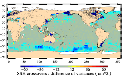 | 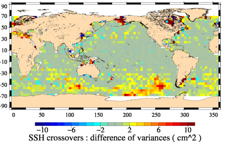 |
| Impact on real-time (OGDR data): Difference of SLA variance at the Jason-2/Jason-2 cross-over positions (on cycles 68 to 103), when DAC correction is used instead of simple Inverse Barometer correction. | Impact on near real-time (IGDR data): Difference of SLA variance at the Jason-2/Jason-2 cross-over positions (on cycles 68 to 103), when DAC correction is using ECMWF analysis only (i.e. DAC operational) and when using the ECMWF analysis and forecast (i.e. DAC optimised). |
Wind/Wave products
Improvements of the Ssalto/Duacs gridded NRT wind/ waves products:
- integration of the new altimeter Saral mission in wave products (Ka-band on Saral AltiKa’s altimeter doesn’t allow to compute wind products). Indeed, after the Jason-1’s lost in June 2013, these products were only based on Jason-2 measurements: many gaps in measurements were noticed. So, the integration of new Saral mission will increase the availability of data.
- A correction for the Jason-2 wind products will be implemented to better estimate the wind speed modulus. Indeed, the wind speed modulus from Jason-2 processing was underestimated.
Ssalto/Duacs gridded wind/wave products are Near-Real Time products. In this sense, only new data files from 2013/09/04 belonging to Ssalto/Duacs V14.0.1 include these improvements (no reprocessing before this date will be done).
Further information on the gridded wind/wave products processing.
July 2013: new Ssalto/Duacs Version V14.0.0: Saral/AltiKa in Duacs; Integration of OGDR Cryosat-2; improvement in management of non repetitive missions
Thanks to a new collaboration between Cnes and Isro, the Saral satellite was launched on February 2013. The AltiKa on-board altimeter showing extremely good performances, Cnes/Isro decided to open the data access to all users for IGDRs and OGDRs products.
The integration of Saral impacts the delivering of Near Real time Along-track Sea Level Anomalies (SLA) and maps of SLA (MSLA).
Generalities about the mission
Saral data are included in the Near Real Time (NRT) Ssalto/Duacs process. |  | |
|---|---|---|
| Example of difference in cm of Ssalto/Duacs maps Jason-2/Jason-1/Cryosat-2 and Jason-2/Jason-1/Cryosat-2/Saral on June 16th 2013 |
The new version of Ssalto/Duacs will also take into account:
- the integration of Cryosat-2 OGDRs in NRT process
- the improvement of the management of the SLA computation in case of non-repetitive mission
The changes will impact the following data and directories:
- New dataset for Saral with "al" in directories and filenames: NRT along-track SLA in directories <REGION>/nrt/sla or adt/al_cf where <REGION>=global, regional-arctic, regional-blacksea, regional-europe, regional-mfstep (ie for Mediterranean Sea)
- Improvement in data coverage/resolution:
- NRT along-track Cryostat-2 SLA in directories <REGION>/nrt/sla or adt/c2_cf , where <REGION>=global, regional-arctic, regional-blacksea, regional-europe, regional-mfstep
- NRT merged gridded MSLA in directories <REGION>/nrt/msla/merged/*, where <REGION>=global, regional-blacksea, regional-mfstep
- Improvement in product:
- NRT along-track Cryostat-2 SLA in directories <REGION>/nrt/sla or adt/c2_cf , where <REGION>=global, regional-arctic, regional-blacksea, regional-europe, regional-mfstep
- NRT merged gridded MSLA in directories <REGION>/nrt/msla/merged/*, where <REGION>=global, regional-blacksea, regional-mfstep
Please, refer to the <link file:2217 hdbk>Handbook to have complete information
Please contact the Aviso user services if you need assistance in accessing or using any Aviso product.
June 2013: Temporal extension up to December 26, 2012 of Ssalto/Duacs delayed time (DT) products
Delayed-Time products (both versions "Reference" and "Updated") have been extended up to December 26, 2012. They are available via the ftp.aviso.oceanobs.com server with your login/password and also, for gridded products, via extraction tools with specific login/password.
The monthly means have also been updated as well as annual and seasonal climatologies.
Note that for gridded products, this update only concerns the "weekly products" (i.e. one file produced by week), the "daily products" (i.e. one file produced every day) Delayed-Time products are not concerned by this update.
April 2013: Temporal extension up to November 21, 2012 of Ssalto/Duacs delayed time (DT) products
Delayed-Time products (both versions "Reference" and "Updated") have been extended up to November 21, 2012. They are available via the ftp.aviso.oceanobs.com server with your login/password and also, for gridded products, via extraction tools with specific login/password.
The monthly means have also been updated.
Note that for gridded products, this update only concerns the "weekly products" (i.e. one file produced by week), the "daily products" (i.e. one file produced every day) Delayed-Time products are not concerned by this update. Indeed, this production is experimental and temporary but could be permanent if you show us its value for your works: contact us! (By email to aviso(at)oceanobs.com, quoting "Feedback about the daily gridded DT production")
February 2013: new version of Ssalto/Duacs V13.5: implementation of "OGDR on the fly" in NRT processing
As you may know, since September 2011, the production of Global Along-track Real Time products called "OGDR on the fly" is performed experimentally (see our news ). The Duacs processing chain delivers via ftp the most recent available data in "global/rt/sla" and "global/rt/adt" directories several times per day. The generation of these products consists in completing the Global Along-track NRT products with the latest OGDR data received.
The Aviso team is pleased to inform you that, as from February 12th, 2013, the delivery of such products will now be done directly in the Near-Real time directories (double dissemination until February 28). Indeed, the Global Along-track NRT products (for Jason-1 and Jason-2 missions) will be updated several times per day in order to include the most recent available OGDR data.
For example, if you download files from global/nrt/sla/j1g_cf or j2_cf or global/nrt/adt/j1g_cf or j2_cf directories at 15:00 for the day D:
- at the present time, the last date of data that you can get in the last file delivered is ~20:00 of the day D-1.
- as from February 12, the same file will be updated and a new one created and updated and you will get data until 13:00 of the day D at the best (if OGDR is valid).
Along-track NRT Cryosat-2 and Gridded NRT products are not concerned. There is no impact on the scientific quality of the products.
As already mentionned, a double dissemination until February 28 is foreseen allowing you some time to change your scripts; this means that until February 28, the "rt" directories don't change and they will be erased after this date. You will find "OGDR on the fly" data in:
| before February 12 | between February 12 and February 28 | after February 29 |
|---|---|---|
global/rt/sla/j1g_cf global/rt/sla/j2_cf global/rt/adt/j1g_cf global/rt/adt/j2_cf | global/rt/sla/j1g_cf and global/nrt/sla/j1g_cf global/rt/sla/j2_cf and global/nrt/sla/j2_cf global/rt/adt/j1g_cf and global/nrt/adt/j1g_cf global/rt/adt/j2_cf and global/nrt/adt/j2_cf | global/nrt/sla/j1g_cf global/nrt/sla/j2_cf global/nrt/adt/j1g_cf global/nrt/adt/j2_cf |
Example
for the example of the process on 2013-01-15, in file global/nrt/sla/j2_cf/nrt_global_j2_sla_vfec_20130114_20130114_20130115.nc.gz, the date of the last measurement is 2013-01-14 19:35:42
this file was created when the process began at 22:30 on January 14.
If the new version of Duacs was running:
- a new process would have begun around 2:00 on January 15 and the file nrt_global_j2_sla_vfec_20130114_20130114_20130115.nc.gz would have been updated and would have contained data until 2013-01-14 23:59
- a new process would have begun around 6:00 on January 15 and the file nrt_global_j2_sla_vfec_20130115_20130115_20130115.nc.gz would have been created and would have contained data until 2013-01-15 4:00
- a new process would have begun around 8:00 on January 15 and the file nrt_global_j2_sla_vfec_20130115_20130115_20130115.nc.gz would have been updated and would have contained data until 2013-01-15 6:00
- and so on...
The chain runs 1 to 10 times per day if new OGDR data is available.
So if you get files during the day, you will need to get 22 files nominally, the last two files being updated compared the current situation. Note also that some older files (not more than 3 days) can be updated if new IGDR data arrive and erase older OGDR data (a flag indicates in the file the input data: 1 for IGDR and 0 for OGDR).
January 2013: Temporal extension up to July 18, 2012 of Ssalto/Duacs delayed time (DT) products
Delayed-Time products (both versions "Reference" and "Updated") have been extended up to July 18, 2012. They are available via the ftp.aviso.oceanobs.com server with your login/password and also, for gridded products, via extraction tools with specific login/password.
This update takes into account
- the integration of Jason-1 on its geodetic orbit: the last date available for "j1n" is March 7, 2012 and "j1g" is a new mission beginning on June 12, 2012
- the new version "D" of Jason-2 input products (GDRs) since June 18, 2012 (complete information on version D)
- the end of Envisat mission on April 8, 2012
The monthly means have also been updated.
Note that gridded "Daily" Delayed-Time products are not concerned by this update. This production is experimental and temporary but could be permanent if you show us its value for your works: contact us! (By quoting "Feedback about the daily gridded DT production")
December 4th 2012: Version 13.3 of SSALTO/Duacs: improvement of Cryosat-2 processing
This new version improves the processing of Cryosat-2 data:
- a better tuning of altimeter parameter and correction (backscatter coefficient and thus the Sea State Bias correction) improving the SLA stability,
- a new editing process allowing to improve the SLA quality notably in sea ice areas.
You can find information in Labroue S., A. Ollivier, M. Guibbaud, F. Boy, N. Picot, P. Féménias, “Quality assessment of Cryosat-2 altimetric system over ocean”, OSTST 2012 in venice
The nomenclature, format, ... remains unchanged. This will have a scientific impact (see poster) on the Near Real Time global and regional Along Track Cryosat-2 products (nrt/sla/c2_cf and nrt/adt/c2_cf) as well as Near Real Time global and regional gridded merged products (nrt/msla/merged and nrt/madt/merged).
September 2012: Temporal extension up to April 18, 2012 of Ssalto/Duacs delayed time (DT) products
Delayed-Time products (both versions "Reference" and "Updated") have been extended up to April 18, 2012. They are available via the ftp.aviso.oceanobs.com server with your login/password and also, for gridded products, via extraction tools with specific login/password.
This update takes into account the integration of Cryosat-2 data into Delayed Time products.
Note that gridded Delayed-Time products with daily temporal resolution are not concerned by this update. This production is experimental and temporary but could be permanent if you show us its value for your works: contact us! (By quoting "Feedback about the daily gridded DT production")
1st August 2012: Version 13.2.0 of SSALTO/Duacs: new altimetric standard version "D"
Altimetric data are regularly reprocessed in order to take into account new algorithms, corrections, parameters, etc. Since its launch in June 2008, Jason -2 products have been disseminated in version "C". For Jason -2, it is now time to change for another standard to benefit from many years of progress in altimetry.
Main differences between versions "C" and "D" are described in the links below.
Further information:
- [Jason-2]: Information about the new altimetric standard version "D"
- Ssalto/Duacs <link file:2217 download>User Manual: M( SLA ) and M( ADT ) Near-Real Time and Delayed-Time
Release of new regional products: Coastal DT SLA Jason-2

A new dedicated coastal product is now delivered by Aviso.
Thanks to Jason-2 Coastal Pistach level-2 products, it has been shown that more altimetry data are recovered in coastal areas compared to standard GDR or Aviso products (L3 subsampled and filtered SLA).
In order to provide “easy to use” coastal level-3 products (Sea Level Anomalies) to meet the needs of the scientific community, coastal sla jason-2 experimental products are proposed.
Four areas are delivered:
- Agulhas current (5 passes),
- Florida Strait (1 pass),
- Oregon (4 passes),
- Mid Atlantic Bight (2 passes).
All information on the dedicated page product or in the User Handbook (nomenclature, temporal availability, product generation or corrections applied, ...).
The data are available through an authenticated ftp server; please fill in the form by selecting the product "Coastal Jason-2 DT-SLA; few areas". Then, a user account will be sent to you.
Further information:
Data Use Case with the Basic Radar Altimetry Toolbox dedicated to this Jason-2 Coastal level-3 products:
June 2012: Temporal extension up to February 8, 2012 of Ssalto/Duacs delayed time (DT) products
Delayed-Time products (both versions "Reference" and "Updated") have been extended to February 8, 2012. They are available via the ftp.aviso.oceanobs.com server with your login/password and also, for gridded products, via extraction tools with specific login/password.
Note that gridded Delayed-Time products with daily temporal resolution are not concerned by this update. This production is experimental and temporary but could be permanent if you show us its value for your works: contact us! (By quoting "Feedback about the daily gridded DT production")
June 2012: Temporal extension up to December 7, 2011 of Ssalto/Duacs delayed time (DT) products
Delayed-Time products (both versions "Reference" and "Updated") have been extended to December 7, 2011. They are available via the ftp.aviso.oceanobs.com server with your login/password and also, for gridded products, via extraction tools with specific login/password.
Note that gridded Delayed-Time products with daily temporal resolution are not concerned by this update. This production is experimental and temporary but could be permanent if you show us its value for your works: contact us! (By quoting "Feedback about the daily gridded DT production")
May 25th 2012:Version 13.0 of SSALTO/Duacs: Integration of Jason-1 geodetic orbit in NRT products and stop of Envisat mission
A new release of Duacs (version 13.0) was installed and activated on the production servers from May 25, 2012.
- Integration of Jason-1 on its geodetic orbit since May 7, 2012 in NRT products.
- Stop of Envisat data in the processing
Complete information can be found in the operational news
New release of Ssalto/Duacs NRT: v12.0.1
A new release of Duacs (version v12.0.1) has been installed and activated on the production servers from April 03, 2012. Here are the updates:
- For along-track products in Near-Real Time and Real-Time, the old format NetCDF is definitively replaced by the new format NetCDF CF, as announced since September 2011.
- For Near-Real-Time maps in Mediterranean Sea (gridded products), improvement of the coverage in the Alboran Sea, the Marmara Sea and near the coasts.
April 2012: new format NetCDF-CF is the only available format for Ssalto/Duacs along-track products
As announced since September 2011 and in several reminders sent by emails, the old format NetCDF is definitively replaced by the new format NetCDF CF for all along-track products in Delayed-Time, Near-Real Time and Real-Time
NB: CorSSH and SLA monomission are not yet concerned by this new NetCDF CF format.
March 2012: Temporal extension up to September 2011 of Ssalto/Duacs delayed time (DT) products
Delayed-Time products (both versions "Reference" and "Updated") have been extended to September 2011. They are available via the ftp.aviso.oceanobs.com server with your login/password.
Note that gridded Delayed-Time products with daily temporal resolution are not concerned by this update. This production is experimental and temporary but could be permanent if you show us its value for your works: contact us! (By quoting "Feedback about the daily gridded DT production")
February 2012: Cryosat data available on Duacs
Duacs data derived from the Esa mission Cryosat-2 will be delivering by Cnes on February 06th . All near-real time multi-mission products from Duacs [1] will be exploiting 4 altimeters (Jason-2, Jason-1, Envisat and Cryosat-2).
This major change is the result of the long-standing and fruitful partnership between Esa and Cnes and a response to the request from scientific and operational oceanography users [2].
The Duacs multi-mission system will be ingesting data flows generated by Cnes' Cryosat Processing Prototype (CPP) which are derived [3] [4] from Level 0 data flows from Esa. The CPP processor includes a pseudo-LRM handling of Cryosat's innovative SAR mode [5]. Duacs will therefore benefit from a full global coverage of the Cryosat-2 altimeter. This coverage notably includes European Seas, the Agulhas area, and high latitudes latitudes (up to 89° for the first time ever).
 | There are three benefits for Duacs users : 1- more along-track SLA data for model assimilation, Adding Esa's L1B and L2 products [7] and Noaa's recent Cryosat announcement [8], a wide range of Cryosat data should be available to the oceanography, geodesy, and weather forecast communities. Esa has also announced an improved ocean L2 product (IOP) in Spring 2012 [9]. |
|---|---|
Multi-mission map of Sea Level Anomalies on 2012/01/01 exploiting 4 altimeters: Jason-2, Jason-1, Envisat and Cryosat-2. Credits Cnes-Ssalto/Duacs-Esa. |
On February 2012, a new 4-satellite configuration is available with the ingestion of the Cryosat-2 data flows in the Duacs multimission system (Jason-1; Envisat, Jason-2 and Cryosat-2 ). It allows more along-track data for model assimilation, higher resolution of multi-mission mesoscale maps and better resilience of the multi-mission observation system if an old altimeter becomes unavailable
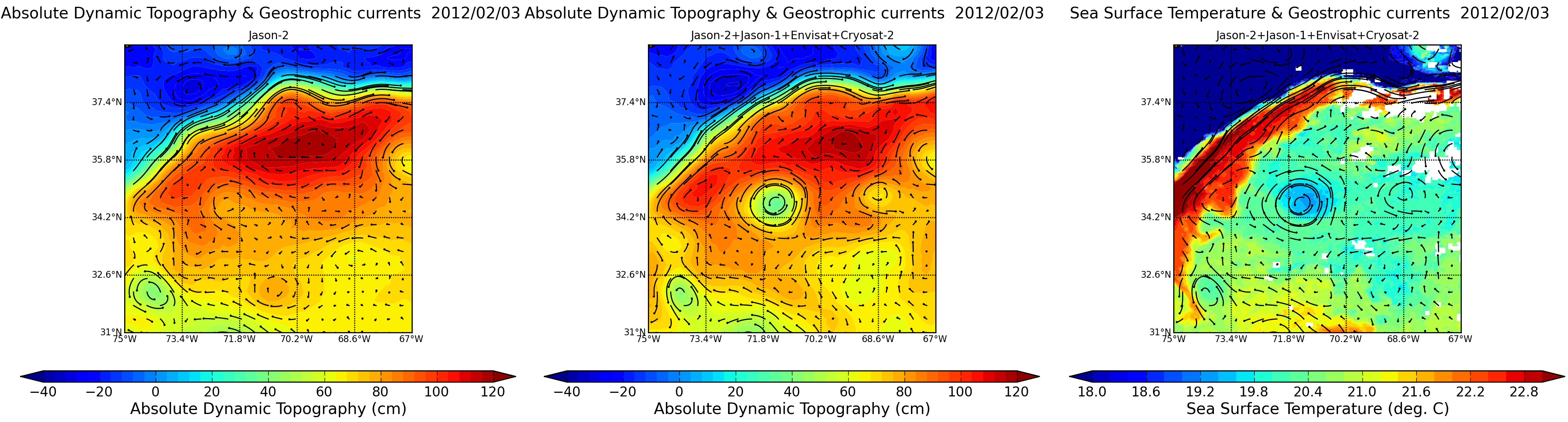
Maps of Absolute Dynamic Topography (in m) superimposed to absolute geostrophic currents (m/s) in the Atlantic Ocean on 2012/02/03 made from Jason-2 (left) and Jason-1+Envisat+Jason-2+Cryosat-2 (middle). Sea Surface Temperature- SST (in °C, right) superimposed to geostrophic currents. Merging of the four satellite data shows eddy (near 71.8°W, 34.2°N) that are invisible, or just barely visible with only one satellite and much better sorted out with four of them. The SST map shows the same eddy which corroborates the findings of the altimetry (Credits CLS/Cnes).
However please note that all Cryosat products from Cnes are generated within 24 to 48 hours on a best effort basis, and that Cryosat has a higher error budget than other altimeters because of its cryosphere-oriented design (no radiometer, no dual frequency ionosphere, drifting orbit) [6]. Yet no major anomaly nor delay has been identified on the Duacs test system since November 2011.
Further information:
- [1] Duacs data: Level 3 along-track SLA, and Level 4 multi-mission mesoscale maps, both global and regional.
- [2] Following the scientific recommendations from the OSTST meeting (San Diego, October 2011), the ESA Cryosat Project and the CNES SALP Project have been collaborating to generate these Cryosat-derived L3 and L4 products. Level 1B and Level 2 products derived from CNES processors are not distributed by AVISO as per the CNES / ESA agreement.
- [3] Picot.N., F.Boy (2011): CryoSat Processing Prototype, LRM Processing on CNES Side and a Comparison to DUACS SLA. Proceedings of the 2d Cryosat Validation Workshop (Frascati, 2011
- [4] Labroue.S et al (2011): First Quality Assessment of the CryoSat-2 Altimetric System over Ocean. Advance in Space Research (In Press). http://dx.doi.org/10.1016/j.asr.2011.11.018
- [5] Boy.F et al (2011): Cryosat LRM, TRK and SAR processing. Presented at the 2011 Ocean Surface Topography Science Team meeting (pdf).
- [6] Dibarboure et al (2011): A demonstration of the potential of Cryosat-2 to contribute to mesoscale observation. Advance in Space Research (In Press). http://dx.doi.org/10.1016/j.asr.2011.07.002
- [7] Esa website: How to access to Cryosat data
- [8] NOAA/NESDIS LSA CryoSat Interim Geophysical Data Record (IGDR)
- [9] Bouzinac et al, 2011: New CryoSat Ocean Products, Presented at the 5th Coastal Altimetry Workshop (pdf).
January 2012: Erratum: Some along-track files corrupted for drifting missions (enn and e1)
An anomaly has been detected in the along-track files of drifting orbit missions (ERS-1 during years 1994-1995 and Envisat on it new orbit: ENN). They have been replaced on the authentified ftp by the new files with the production date of 20120116 (the last date in the name of the files).
If you have already downloaded the files listed here, please download them again on the ftp.
The error is due to a problem in the numbering of the cycles in computation of along track products. Therefore, in all the files listed, there was an anomaly in the numbering of the cycle for the last track of one cycle (pass 1002 for ERS-1 and pass 862 on Envisat). Note that the corresponding dates and measurements were correct.
January 2012: Erratum on the last release Ssalto/Duacs Delayed-Time products
Some data files released during the last Ssalto/Duacs Delayed-Time temporal extension (see December 2011: Temporal extension up to July 2011 of Ssalto/Duacs delayed time (DT) products below) appeared to be erroneous and are now corrected.
Indeed, the coordinates grid (lon/lat) was not well defined and may cause an erroneous reading with some softwares (whereas others sofwares are not impacted).
If you have already downloaded the files for the data period between 2011/01/12 and 2011/07/06 (or in other words for all the production date of 2011/12/08), please check them with the softwares you use: Delayed-Time, updated and reference series for Global area in Maps of Sea Level Anomalies for the height and formal mapping error variables, with a weekly resolution (the MSLA with a 1/4° and 1° spatial resolution, respectively the filenames with *msla_h_qd* and *msla_h_lr*; and the geostrophic velocities UV are not concerned). In details, the following folders and files were impacted:
- /global/dt/ref/msla/merged/h/, data files between
- dt_ref_global_merged_msla_h_20110112_20110112_20111208.nc.gz and
- dt_ref_global_merged_msla_h_20110706_20110706_20111208.nc.gz
- /global/dt/ref/msla/merged/err/, data files between
- dt_ref_global_merged_msla_err_20110112_20110112_20111208.nc.gz and
- dt_ref_global_merged_msla_err_20110706_20110706_20111208.nc.gz
- /global/dt/upd/msla/merged/h/, data files between
- dt_upd_global_merged_msla_h_20110112_20110112_20111208.nc.gz and
- dt_upd_global_merged_msla_h_20110706_20110706_20111208.nc.gz
- /global/dt/upd/msla/merged/err, data files between
- dt_upd_global_merged_msla_err_20110112_20110112_20111208.nc.gz and
- dt_upd_global_merged_msla_err_20110706_20110706_20111208.nc.gz
If you have encountered some difficulties to plot these last files, we invite you to download again the new corrected files that the production date is 2012/01/16 (which is the third date in each filename), on the authenticated data access services.
January 2012: Modifications and Upgrade on the Opendap and the Extraction Tool
Since October 2011, the Ssalto/Duacs Delayed-Time MSLA and MADT were integrated through the Opendap with the daily resolution (by default, the weekly resolution was also included in this dataset).
In order to integrate to the Opendap and the Extraction Tool, the latest DT extension made on the ftp server for weekly products (extension up to July 2011), a new dataset is created to offer at once the weekly and the daily resolutions. The daily resolution is integrated in a new dataset whereas the old dataset contains only the weekly resolution (see table below for the detailed filenames).
The temporal extension of these two datasets are different since the daily resolution was made as an experimental and temporary production and therefore, it is not upgraded at each Delayed-Time extension:
- up to July 2011 for the weekly resolution (ie the latest temporal extension),
- up to January 2011 for the daily resolution.
Finally, an upgrade on the Extraction Tool enables to offer a new service. On each last page where you can download the data (after you have defined your own dataset), a new "script" button allows you to access on Python script command lines that matches the current extraction. These command lines help you to make your own script from the shell of you system (Linux/Unix/window).
| Weekly resolution | Daily resolution: new dataset | |
|---|---|---|
| Global | dataset-duacs-dt-upd-global-merged-msla-h | dataset-duacs-dt-upd-global-merged-msla-h-daily |
| Mediter- ranean Sea | dataset-duacs-dt-upd-medsea-merged-msla-h dataset-duacs-dt-upd-medsea-merged-madt-h dataset-duacs-dt-ref-medsea-merged-msla-h dataset-duacs-dt-ref-medsea-merged-madt-h | dataset-duacs-dt-upd-medsea-merged-msla-h-daily |
| Black Sea | dataset-duacs-dt-upd-blacksea-merged-msla-h dataset-duacs-dt-ref-blacksea-merged-msla-h | dataset-duacs-dt-upd-blacksea-merged-msla-h-daily |
Further information:
- Data access services: Authenticated Opendap and Extraction Tool
- If you are not registered and want to access those services (NB. for scientifc uses only), we request you to fill in the online form: http://www.aviso.oceanobs.com/en/data/registration-form/
January 2012, New Duacs NRT Along-Track regional products: Arctic and Europe
Two new Duacs regional products are released on Wednesday, 11th January 2012: Arctic Ocean and Europe area, for addressing the needs of data assimilation and validation in regional models.
Those new products include Along-track multimission Sea Level Anomalies data in Near-Real Time.
They are delivered via authenticated FTP (see Access to Ssalto/Duacs products). If you already have an FTP account, your access is automatically updated; this means that no new subscription is required.
The data are in the following folders: regional-arctic/ and regional-europe/ .
The Geographic coverage includes:
- for Arctic area, an enlarged Arctic Ocean : 45°N-82°N / 0°-360°E
- for Europe area: 21°N-66°N / -25°W-42°E (Iberic-Biscaye-Ireland and Northwest shelves areas ; Baltic, Mediterranean and Black Seas).
 |  |
|---|---|
Along-track Envisat Sea Level Anomalies data in Near-Real Time, between 2011/10/28 and 2012/01/03, for the regional products Arctic Ocean (left) and Europe (right). Maps plotted with the Basic Radar Altimetry Toolbox. Credits CLS/Cnes | |
Following the initiative launched by TAPAS (Tailored Altimeter Product for Assimilation Systems) in the MyOcean project with all the Modeling and Forecasting Centers (MFCs), the Europe regional products has been processed with adapted filtering and resolution. Those parameters as well as the coverage have been tuned in order to provide boundary conditions for the Atlantic assimilation models.
Indeed, the Europe area includes, among others, the Mediterranean and Black Seas which already belong to dedicated regional products (in regional-mfstep and regional-blacksea folders). However, note that if you need to study the Mediterranean or the Black Sea, you'd better use the dedicated regional products since the processing parameters have been fitted to be adapted to the dynamics of the ocean in those regions, which is not the case for the Europe product.
Nomenclature, temporal availability, product generation or corrections applied can be retrieved in the <link file:2217 pdf download>Ssalto/Duacs User Handbook.
December 2011: Temporal extension up to July 2011 of Ssalto/Duacs delayed time (DT) products
Delayed-Time products (both versions "Reference" and "Updated") have been extended to July 2011. They are available via the ftp.aviso.oceanobs.com server with your login/password.
Note that gridded Delayed-Time products with daily temporal resolution are not concerned by this update. This production is experimental and temporary but could be permanent if you show us its value for your works: contact us! (By quoting "Feedback about the daily gridded DT production")
October 2011: new version of Ssalto/DUACS v11.0.2 - RT and NRT Along-Track products improved
A new release of DUACS (version 11.0.2) has been installed and activated on the production servers from October 19, 2011. Here are the improvements:
Better accuracy of Envisat data at high latitudes
Since orbit Envisat is on a drifting orbit, the Mean Sea Surface (MSS_CNES_CLS_2011) is used to calculate the Envisat Along-Track SLA. Although the MSS is defined over the global ocean, its accuracy is reduced on the high latitudes areas due to the lack of altimeter measurement which does not allow constraining the MSS to incorporate the medium/small scale, representative of the mean dynamic circulation. In this case the MSS was only based on the geoid. The improvement of this new release of DUACS consists on a specific editing that removes erroneous measurements on these areas.
The OGDR processing has been improved
Thanks to the vigilance of a user, a minor anomaly on the NRT products has been detected (IGDR data are not impacted). To solve this problem, the OGDR filtering has been improved to better reproduce the mesoscale signals. Therefore the overall NRT products are of better quality.
Find further explanations in the <link file:2217 download>DUACS user guide.
September 2011: new release of seasonal/monthly means and climatology maps.
The monthly means, seasonal means and climatological Maps of SLA have been reprocessed using the extended delayed-time maps in daily temporal resolution (instead of weekly maps in the past - see the related topic). The areas concerned are global ocean, Mediterranean and Black Seas.
This processing provides finest averages and extends the monthly mean and climatological maps up to January 2011.
The file metadata has been adjusted to match with the <link en data tools data-format index.html>NetCDF standard, used by most reading software for altimetric data as <link en data tools software index.html>BRAT, ncBrowse, etc.
To access these products, please refer to the dedicated web pages:
Mediterranean Sea
September 2011: new release of DUACS v11.0.0 - NRT products mainly concerned
A new version of Duacs (version 11.0.0) has been installed and activated on the production servers from September 14, 2011. Here are some notable upgrades:
- New format for the along-track products in Near Real-Time
- New Real-Time products on OGDR flow reception
- Integration of the GOT4.8 tides model for the along-track and gridded products
- New MSS CNES/CLS 2011 for Envisat products
New format for the NRT Along-track products
This new Duacs version provides along-track data in Near Real-Time with a new format following the standard NetCDF CF-1.4 (Climate and Forecast), making their use easier. Further information about this format at http://cf-pcmdi.llnl.gov/.
For both formats, in Near Real-Time mode, a maximum of 21 days of data are still processed and delivered but products in the new format CF are now daily (i.e. a single file contains 24 hours data while an old format file contains 21 days data).
Example: the old format data in the file 'nrt_global_j2_sla_vfec_20110825_20110914_20110915.nc' are contained in 21 different new format CF files:
'nrt_global_j2_sla_vfec_20110825_20110825_20110915.nc'
'nrt_global_j2_sla_vfec_20110826_20110826_20110915.nc'
...
'nrt_global_j2_sla_vfec_20110914_20110914_20110915.nc'
For both modes (NRT and DT), filename nomenclature, paths and access rights are the same: the new format CF files are stored in folders suffixed with "_cf" at the same levels as folders containing older format files. Example: in the FTP folder 'global/nrt/sla/', folders j2/ and j2_cf/ contain respectively data in the old format and new format CF for the Jason-2 mission.
This new format has no impact on the scientific content.
Note that DUACS NRT and DT products with the old format will still be distributed until the end of January 2012, leaving you time to adapt to the new format CF. Beyond that date, the new format CF will be the only available format for both modes (NRT and DT); be sure to be kept informed of such an operation.
Production of new Real-Time products 'OGDR on the fly'
In the previous Duacs production chain (v10.1.0), the OGDR data received during the day were included in products when the production starts, i.e. about 22h30 UTC. Consequently, depending the time at which the user wanted to get these data, the most recent ones could be missing.
To meet this need, the DUACS production chain now generates new RT product called 'OGDR on the fly'. The generation of these products consists in completing the Along-track products with the latest OGDR data received [see diagrams explaining].
In summary, to get the most recent data, just combine the latest NRT daily files (available in nrt/ FTP folders) with these RT products. Only the global product is concerned for the moment and OGDR on the fly data are stored in the FTP folder 'global/rt/'.
Correction of the GOT4.8 tides model
GOT4.8 is the latest version of tides model. This model has been integrated into the NRT Duacs products (both along-track and gridded). Concretely, the products taking advantage of GOT4.8 version are the NRT products with the two formats (see section above 'New format for products DUACS Along-track') and whose production date is later to September 14 ('Duacs v11.0.0' version) while products prior to this date and the release DUACS v11.0.0 include the model GOT4.7.
New MSS CNES/CLS 2011 for Envisat
Due to the Envisat orbit change, the Sea Level Anomalies (SLA Envisat) have to be derived from the Mean Sea Surface instead of Mean Profile and repeat track analysis (see news "<link en data product-information duacs presentation updates>November 2010: Envisat back in Ssalto Duacs v.10")
The new version of MSS (MSS_CNES_CLS2011) is now applied to NRT Along-Track Envisat products whose production date is later to September 14. For more information, see the MSS web page.
July 2011: the series of daily Ssalto/Duacs gridded Delayed-time data has been extended to January 2011
The gridded Delayed-Time products computed with a daily temporal resolution are now available until January 19th, 2011 (instead of March 31rd, 2010 before this reprocessing). The concerned products are the two processing series ("ref" and "upd") of MSLA and MADT data for the global and Mediterranean Sea, MSLA data for the Black Sea.
You can now access to these daily maps with your usual login/password if you've already a FTP account. If not, please fill in the <link en data registration-form external-link-new-window>registration form.
This production is still experimental and temporary but may be permanent if you show us its value for your works: contact us ! (please quoting "Feedback about the daily gridded DT production" ).
June 2011: the Ssalto/Duacs Delayed-Time products updated
All the Delayed-Time products (both versions "Reference" and "Updated") have been updated. The latest DT maps and along-track files are now dated the January, 19th, 2011 on the ftp server.
April 2011: Ssalto/Duacs gridded Delayed-time products now available for each day
Motivated by the fact that the weekly resolution used so far for DT maps was insufficient wherever the time decorrelation scale is close to 15 days, the gridded Delayed-Time products have been computed with a daily temporal resolution using the same DUACS processing system than before.
So now, for each day from October 14th 1992 to March 31th 2010 and for global, Black Sea and Mediterranean Sea, there are maps representing the sea surface anomalies and absolute dynamic topography (products called MSLA and MADT) while up to now, the snapshots were produced every 7 days.
You can now access to these daily maps with your usual login/password if you’ve already subscribed to get them. If not, please fill in the registration form.
This production is experimental and temporary but may be continued if you show us its value for your works: contact us ! (please fill in the subject with "Feedback about the daily gridded DT production" ).
April 2011: the Ssalto/Duacs Delayed-Time products updated
All the Delayed-Time products (both versions "Reference" and "Updated") have been updated. The latest DT maps and along-track files are now dated the December 1st, 2010 on the servers.
Note that a delivery of updated gridded DT products with a daily temporal resolution will be made soon ...
April 2011: update of Ssalto/DUACS NRT products v10.1.0
Newly established, this new version affects along-track and gridded data for regional products and consists of improvements and a new product. Please, find below some explanations about these changes:
- Release of new regional configuration: Mozambique area
Aviso is now distributing a new sea surface height (SSH) product reproducing the dynamics of the Southwest Indian Ocean. Geographic coverage: from 30°S to 0°N and from 30°E to 60°E, as shown in the figure hereafter.
Yet, this product contains Near-Real Time products: - Along-track multimission SLA data based on MDT_CNES-CLS09 with a 14km spatial resolution.
- Gridded SLA maps with formal mapping error files and geostrophic velocity maps. The grid used for maps construction presents a spatial resolution of 1/8°Х1/8°.
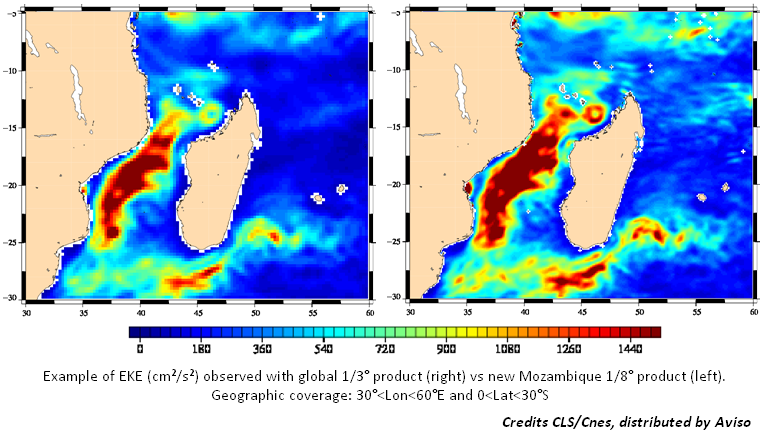
Those new products should allow a better reproduce current dynamics and main eddies all around Madagascar Island (higher along-track resolution with an improved noise level and higher quality coastal data).
- Mediterranean SSH product improvements
The scientific content of the along-track Mediterranean Sea surface height product in NRT has been improved and now available.
- The first change included in this evolution allows to take into account more along-track data in the Alboran Sea (western Mediterranean Sea) in order to better reproduce the eddies dynamic in this area
- The second change impacts the products geographic coverage which is extended to 0.5° toward West in order to completely include the Gibraltar strait.
NB.: associated gridded SLA and ADT maps will be available in coming months
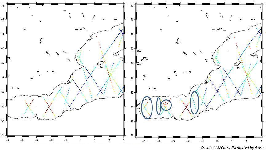
March 2011: update of Ssalto/DUACS NRT products v10.0.2
This new version includes a few minor corrections which have a very small impact on DUACS NRT data quality. Please, find below some explanations about these improvements:
- Correction of flag values allocation for NRT SLA products:
A new flag was added for last update mid-November in order to determine the origin of data between the different types of geophysical data records (GDR) used in computation of the SLA. This flag had some problems that have been solved within this version.
Now, the flag_values takes the value 1 for the Interim GDR (IGDR) and 0 for Operational GDR (OGDR).
- New Google Earth products:
In order to be accessible by anyone, new maps in Google Earth format are available via Aviso web page section 'Visualize the data' on the right.
These files in .kmz format contain:
- graphical mapping of the latter MSLA data produced and of MADT one (if any).
- Ground tracks of the satellites used in the computation of the gridded data and tracks expected in the coming days.
- Minor correction of the CNES/CLS09 v1.1 MDT:
A local default in this file has been corrected; it concerns only one pixel with invalid value and located on an island on the coast of Ecuador called "Isla Punà" (coordinates 80°08' W, 2°47' S)
![]()
Note that respective NRT MADT products were not reprocessed considering the low impact of a pixel data and its position.
November 2010: Envisat back in Ssalto Duacs v.10
As mentioned in earlier messages, Envisat has been recently moved to a new orbit and to a different ground track. The dissemination of the first Envisat data on its new track started in early November, but as a conservative measure, Envisat processing in DUACS had been stopped until today.
First of all, the analyses of Envisat data on the new orbit exhibit no major instrumental anomaly on Level 2 Sea Surface Height data from ESA.
Second point is that the orbit change means that in place of a Mean Profile and repeat track analysis, Envisat sea level anomalies must be derived from a gridded Mean Sea Surface. This is made possible by the recent improvements of recent gridded MSS (CNES/CLS10, DTU10, DNSC08). However, using a gridded MSS in place of a precise along-track reference involves additional errors. Various analyses were recently performed and presented to the Ocean Surface Topography Science Team. We think the error on DUACS products is not a showstopper, but not a trifle either.
Considering the large improvements associated with an additional satellite in Near Real Time, we decided to re-activate Envisat processing in Near Real Time. The good sampling complementarity between Envisat and the Jason tandem, and the good instrumental behaviour of Envisat largely outshine the degraded accuracy linked to local MSS imperfections.
However, we strongly encourage DUACS users not to take along-track Envisat data for granted, and to analyze them in details.
We also encourage users of DUACS' along-track SLA to increase the error prescribed (e.g. in assimilation) on ENVISAT SSHA by 2 to 3 cm rms (ideally with higher errors in coastal areas or at high latitudes, where the gridded MSS used is likely less accurate) in order to mitigate the impact of artificial mesoscale signatures (e.g fake stationary eddy) created by gridded MSS residuals errors.
As per usual, any feedback on recent Envisat products is welcome to try and improve the processing of Envisat in DUACS.
For more information see Envisat_back_in_Ssalto_Duacs v10
November 2010: Important changes in the Ssalto/Duacs NRT and RT production systems
In September 2009, a new timeliness dataset was released (Ssalto/Duacs v9.1.0). Based on the enhanced OGDR+IGDR production, this RT production system exploits the most recent datasets available to produce multi-missions maps with 0-day and 3-day delay. This RT production has showed a better resilience, a better precision of the system and a better restitution of ocean variability especially in high energetic areas.
By taking into account these advantages and since it has been running nominally long enough, this RT sub-system will replace the historical IGDR-based NRT sub-system from November 15th, 2010. Nevertheless, during a provisional time (one month), the NRT and RT sub-systems both will be supplied in parallel. This change will be entirely effective on December 15th, 2010 where:
- the old RT production is placed in the nrt/ directory, to become the new NRT production.
A new flag included in the along-track products will indicate the source of the production (OGDR or IGDR). If flag=1, the processed data comes from OGDR; if flag=0, the processed data comes from the IGDR. - the NRT production based on the only IGDR production disappears,
- the rt/ directory won’t be updated and then, it will disappear,
This change in the NRT and RT production systems occurs just after the Envisat orbit manoeuvres in order to include the changes of the new Envisat phase in the Ssalto/Duacs system (see our news Envisat Orbit change impacts on Duacs):
- change in the nomenclature: "EN" will be replaced by "ENN" in all file and directories names to take into account the change of orbit,
- a new repetitive ground track will be used: 30 days with 431 orbits per cycle instead of 35 days-501 orbits per cycle,
- no mean profile for the Envisat track can be used. The alternative is to use the Mean Sea Surface instead (MSS_CNES_CLS10).
Further information in the <link file:2217 pdf download>Ssalto/Duacs user's handbook.
September 2010: The Ssalto/Duacs Delayed-time products updated
All the delayed-time products (both versions "Reference" and "Updated") have been updated. Latest maps and along-track files are dated the 30th of March 2010 on the servers.
July 8, 2010: new Duacs NRT version v9.3
The latest version of the Duacs-NRT software (v9.3.0) has been installed and activated on the production servers.
Here are some notable upgrades:
- a new Mean Dynamic Topography, MDT_CNES-CLS09 is taking into account, allowing to better represent the velocities of geostrophic currents. Note that this new MDT is not referenced to the same level than the previous one, thus MADT values change,
- improved velocity estimate from the MDT in the equatorial band,
- the Long Wavelength Error is computed during the mapping process, allowing to improve the level-4 products (MSLA),
- by using the new mean profiles, new along-track SLA products are computed,
- new corrections and models are applied (tides, Sea State Bias, etc). See tables 3 et 4 in the <link file:2217 pdf download>Ssalto/Duacs User Handbook.
June 2010: New, reprocessed, Ssalto/Duacs DT data and change of distribution policy
The latest version of the Ssalto/Duacs-DT software (v3.0.0) has been installed and activated on the production servers. As we first announced the Aviso data falls under the new data policy ((see below 2010: Duacs Delayed-Time reprocessing). The reprocessed Ssalto/Duacs DT data aren't distributed anonymously as older products were. To get access to these new reprocessed data, you have to fill in the registration form on: http://www.aviso.oceanobs.com/en/data/registration-form/index.html.
These new reprocessed DT series are streched out as fas as the 04th of November 2009.
See illustrations and more details on the parameters used for the Ssalto/Duacs DT-(v3.0.0) products generation and their impact on the product quality on: Ssalto/Duacs reprocessed DT data set (pdf).
2010: MyOcean and change in Duacs data policy
What is MyOcean?
Here is an excerpt from the project description. Feel free to get more information on the project website.
http://www.myocean.eu.org/
MyOcean is the implementation project of the GMES Marine Core Service, aiming at deploying the first concerted and integrated pan-European capacity for Ocean Monitoring and Forecasting.
During years 2009-2011, thanks to FP7 co-funding, MyOcean will lead the setting up of this new European service, grown on past investments in research & development, system development and international collaborations.
MyOcean Service provides the best information available on the Ocean for the large scale (worldwide coverage) and regional scales (European seas), based on the combination of space and in situ observations, and their assimilation into 3D simulation models: temperature, salinity, currents, ice extent, sea level, primary ecosystems...
What is the link with Duacs?
The Cnes/CLS system Duacs is the backbone of MyOcean's Sea-Level Thematic Assembly Center (SL-TAC). The SL-TAC is a production unit which provides operational European forecasting centers with directly usable, mission-coherent and high-quality sea-level data from all past and present sensors.
In the MyOcean framework, Duacs is expected to provide Near Real time, offline and re-analyzed L3/L4 data to the project, to develop new products or to improve existing ones, but also to demonstrate its operational capability (global MyOcean system description, performance indicators, ...) and usefulness. The demonstration is the step towards a possible long term support from Europe to operational oceanography and the associated ocean observation capacity (e.g.: altimetry satellites).
As far as the end-user is concerned, Duacs will comply with two notable requirements from MyOcean:
- All MyOcean products are distributed free of charge for all applications (scientific or commercial) both offline or in near real time
- All MyOcean users must be identified by the project's user desk in order to map data flows from the original provider to the user and above all to try and improve its service towards them
Until 2009, Duacs data were divided into 2 categories: data older than 30 days (anonymous access, free of charge, all applications allowed), and near real time (<30 days) free of charge for scientific use or even commercial if enough scientific value is added to the product (e.g.: assimilation in a model).
The MyOcean data policy has the following notable impacts for Duacs users:
- The along-track data from Duacs are MyOcean products. Therefore the 30 day restriction to commercial application disappears. Anyone, including commercial applications, can now request an access to Near Real Time along-track data from Duacs (along-track SLA, SLA+ and so on). These data are jointly distributed by the MyOcean project and Aviso.
- The multi-mission maps are not in the MyOcean catalogue, but they are an internal validation dataset for project partners. These data are still available free of charge for scientific use. Commercial and non-scientific users can still get access to Duacs data provided that their request is accepted. These data are still distributed by Aviso.
- Anonymous data repositories will be closed on Aviso. A light-weight identification process is required. Generally speaking barely more than name, email and a couple of classical questions are necessary to subscribe for data access.
- This data policy is applicable both for near real time and offline or delayed-time data (e.g.: level 3 derived from level 2 OGDR are considered as under the L3 data policy).
- Lastly, for all datasets delivered free of charge, the license requires explicit source credits in publications and science project reports derived from these data.
So in a nutshell: along-track SLA are free for all, maps are free for scientific use, and all products require a license agreement to get your data access setup. Barring the new identification process, this is basically transparent for all of you since a vast majority of Duacs users are either scientific or add a significant value to the original product that will justify unrestricted data access.
Note that the data policy does not take into account the status of the end-user: if a university is involved in a commercial project, its request will be processed like a private company's would be. Similarly if a scientific entity is granted free data access in response to a request for scientific use only, and if it then starts using these data in a profit-oriented project, then it can be considered a breach of license.
Practical consequences for Duacs users
Here are practical consequences:
- First of all, if you're not using the new FTP server (ftp.Aviso.oceanobs.com), you should get in touch with Aviso or MyOcean to get your access set up. The old repositories will be closed in the coming months.
- If you're using along-track data, you should register for free data access to Aviso or MyOcean. You'll have to sign up the license (e.g.: no redistribution unless formerly accepted by the project), and you should be able to access your data (free of charge),
- If you're using maps for science or non-profit projects, you should register for free data access to Aviso. You'll have to sign up a slightly more restrictive license (e.g. : no commercial use) more or less in line with what was done for NRT data until 2009, and you should be able to access your data (free of charge).
- If you're using maps for commercial use, or if your application is not in line with the standard license agreement (e.g.: web portal but limited to a small number of purely scientific projects), then you should get in touch with Aviso or CLS who will process your request. The (possible) fee associated to data delivery is discussed on a case by case basis.
- If you're using multiple data sets, you'll have to make multiple requests, and your unique data access will be configured accordingly.
2010: Duacs Delayed-Time reprocessing
Introduction
Last year started an ambitious reprocessing of all altimetry data since 1992 (cumulated total of about 55 years of 1 Hz data). Our historical altimetry database has been updated to the most recent reprocessed GDR (e.g.: Jason-1 GDR-C from 2009), but also to up-to-date standards (GDR-C or equivalent), on all missions. Duacs-DT itself has been improved here and there (new processing, better transition from TP to Jason, better mapping parameters) and this reprocessing implements all changes introduced in Near Real Time processing.
One should note that this reprocessing was able to benefit from data, algorithms or experience developed various Cnes projects and reprocessing. The synergy with Cal/Val and MSL activities helped with the long-term climate-oriented coherency, and a better handling of reference missions and regional MSL. The SLOOP project provided a framework for the computation of new Mean Profiles for all missions, and SLOOP will produce better reference surfaces (Mean Sea Surface, and Mean Dynamic Topography) which are used by Duacs for drifting altimetry missions or the computation of Absolute Dynamic Topography.
However due to time or workload constraints, it was not possible to integrate all possible improvements associated to recent projects: Envisat GDR-C reprocessing not yet available, ERS reprocessed data from the REAPER project are not yet available, retracked T/P are still being analyzed, and only a fraction of the coastal improvement from Pistach or Coastalt projects were actually used due to the lack of high-resolution along-track data in Duacs.
The weekly resolution used so far for DT maps was insufficient wherever the time decorrelation scale is close to 15 days, especially when end-users want to perform a simple linear time interpolation between consecutive maps. However, switching to a daily resolution involves the computation of more than 6200 maps (some of them using three or four sensors). Not exactly a trifle. As a release date vs resolution tradeoff, the first batch of DT-2010 maps will be released by spring 2010 with a weekly temporal resolution, and the resolution should be increased to a daily resolution equivalent to the NRT resolution by summer 2010.
Note that the DT-2010 generation falls under the new data policy associated to MyOcean (See MyOcean and change in Duacs data policy). Consequently, it will not be distributed anonymously as older products were. When the new dataset is available on Aviso, you'll have to subscribe to a nominative (or company or lab) data access. As mentioned above, barring the light-weight identification needed, the change should be mostly transparent to all scientific and nonprofit users.
Major changes
Here are some notable upgrades that the new generation Duacs-DT product will include (not exhaustive):
- T/P : new non parametric Sea State bias solution from N. Tran and S.Labroue with up-to-date standards (e.g.: DAC or wind algorithm) and orbit solution
- T/P : new orbit solution, kindly provided by GSFC
- Jason-1 : GDR-C used from 2009 reprocessing
- Jason-1 : used as a reference mission instead of T/P for 2002-2005
- Jason-2 : all GDR used from the mission beginning
- Jason-2 : used as a reference mission from 2008
- Envisat : used in place of ERS from cycle 9, except for missing cycle 15 (still using ERS2 for this 35-day period)
- Envisat : new non parametric SSB solution from S.Labroue
- Envisat : GDR-C orbits used (after Cal/Val certification)
- GFO : new orbit solution, kindly provided by GSFC. The new solution not being available during complex periods, the GDR orbit is also used with empirical coherency restoration in between
- GFO : new non parametric Sea State bias solution from N. Tran and S.Labroue with up-to-date standards and orbit solution (computed after orbit error minimization on calibrated reference missions)
- ERS : minimization of brightness temperature drift before wet tropo computation (NN)
- All missions: GDR-C or better standards applied whenever necessary (GOT4v7, High Resolution DAC correction,...)
- All missions: new mean profiles computed in coherency with the new standards and algorithms. New algorithms were applied to correct for time-averaging period discrepancies (e.g.: T/P != Jason-1) or ocean variability. The new mean profiles are still referenced over 1993-1999 for the sake of coherency, but they integrate a precious information from the most recent missions and datasets.
- All missions: minor upgrades of the editing process and complete re-editing based on new standards and corrections.
- All missions: complete re-computation of the empirical cross-calibration and homogenization processes (orbit error reduction using a reference mission, and long wavelength error minimization)
- Reference missions: revisited bias from T/P to Jason-1 and transition from Jason-1 to Jason-2 in order to correct for geographical discrepancies affecting regional MSL studies carried out on Duacs multi-mission maps. Only the inconsistencies which are explained and understood are minimized (update to 2009 knowledge). No geographical minimization is performed between TP-A and TP-B, no waveform leakage correction is applied in this processing (empirical minimization process not fully certified yet).
- Mapping process: updated suboptimal Optimal Interpolation process to minimize transition artefacts (increases map computation time by a factor of 10)
- Mapping process: map coverage extended at high latitudes (previously dismissed due to lack of confidence in Mean Profile)
- Mapping process: time resolution increased (first release still on 1 map per week basis, to be increased to 2 or 7 maps per week by mid-2010).
November 2009: Migration to new Aviso FTP hardware
Last summer we initiated a migration of the old Aviso FTP server to a more robust architecture. This migration started with the offline data (Delayed Time or DT-class), followed by a duplication of Near Real Time data on old and new hardware. The old repositories will be closed in a few months. If you are not already using ftp.aviso.oceanobs.com (change for ftp.aviso.altimetry.fr), feel free to check out the Duacs documentation and/or to contact the Aviso user service. The Aviso team will provide you the help you need in the migration to the new server.
Note that there is also a product nomenclature change on the new server for NRT data. The historical nomenclature is abandoned in favor of a clearer, albeit slightly more verbose, nomenclature in line with the one used for Delayed Time products. Further details are given in the <link file:2217 hdbk download>Ssalto/Duacs User Handbook (See 5.3 Nomenclature, page 24).
September 2009: Timeliness improvement on IGDR+OGDR derived map
Duacs has been running a second daily production for more than one year. This product generation uses both IGDR and OGDR (or FD GDR from Envisat) data in order to exploit the most recent datasets available. Although still tagged as experimental as a conservative precaution, it has been running nominally long enough. This subsystem will replace the historical IGDR-based NRT sub-system in the coming months. This should be transparent in terms of data access.
If you are currently using the IGDR-based product generation, you should observe two differences:
- Along-track data: thanks to the availability of OGDR data in the second product generation, you'll see up to 48 hours of additional data in the along-track SLA datasets (~50 passes for each mission which is an average of ~300k to 450k valid points total).
- Gridded data (maps): in the historical IGDR-based production, multi-mission maps have a 6-day delay. This availability delay was the historical tradeoff in terms of timeliness vs quality. Since last summer the IGDR+OGDR-based production is computing 3 maps every day:
- A 0-day map, which is the preliminary or draft version of the multi-mission map,
- A 3-day map, which is the intermediate version of the multi-mission map,
- And a 6-day map, which is the final version of the NRT multi-mission multi-map
In other words, each and every NRT map is computed at d0 (day of the map) and update twice (at d0+3 and d0+6).Further information and illustration in the <link file:2217 hdbk download>Ssalto/Duacs User Handbook (See 5.1.1 Temporal availibility, page 17).
November 2009: The Ssalto/Duacs Delayed-time products updated
All the delayed-time Sea Level Anomalies products (both versions "Reference" and "Updated") have been updated. LatestSLA maps and files are dated the 22th of July 2009 on the servers. Have a look on :
July 2009: The Ssalto/Duacs Delayed-time products updated
All the delayed-time Sea Level Anomalies products (both versions "Reference" and "Updated") have been updated. LatestSLA maps and files are dated the 18th of February 2009 on the servers. Have a look on :
June 2009: The Ssalto/Duacs Delayed-time products updated
All the delayed-time Sea Level Anomalies products (both versions "Reference" and "Updated") have been updated. LatestSLA maps and files are dated the 31th of December 2008 on the servers. Have a look on :
April 2009: New NRT regional products on Black Sea
New NRT and RT regional dataset on Black Sea : Along-track and combined maps with regional-specific parameters for the Black Sea. These data are generated with the same processing and parameters as for the offline (DT) and re-analysis (RAN) performed by Duacs last year. Access to the NRT and RT regional Black Sea products.
April 2009: The Ssalto/Duacs Delayed-time products updated
All the delayed-time Sea Level Anomalies products (both versions "Reference" and "Updated") have been updated. LatestSLA maps and files are dated the 03th of December 2008 on the servers. Have a look on :
March 3, 2009 - NRT v9.0.0
The latest version of the Duacs-NRTsoftware (v9.0.0) has been installed and activated on the production servers.
New operational dataset : Re-integration of Jason-1 on the new interleaved ground track. After a few months with only two satellites, Duacs benefits from the excellent sampling provided by a coherent Jason tandem. Science parameters used to process Jason-1 are a combination of the parameters used for Jason-1 on its original ground track, and old parameters used to process the historical TP interleaved dataset. Interleaved Jason-1 will be available on all along-trackdata (NRT, NRT+RT, global, regional, SLA, ADT), and these data will be merged with Jason-2 and Envisat in all combined maps.
New demonstration dataset : Along-track and combined maps with regional-specific parameters for the Black Sea. These data are generated with the same processing and parameters as for the offline (DT) and re-analysis (RAN) performed byDuacs last year. The demonstration production will be carried in Near Real Time and in NRT+RT mode. Access to theNRT regional Black Sea products.
Improved processing : the Mediterranean Sea regional products have been upgraded to better match the quality of the offline dataset (Duacs-DT)
Improved processing : Upgrade of the OGDR (aka Real Time or FDGDR or OSDR) data editing and overall processing to better handle altimeter flows with degraded quality or unusual status (e.g. : manœuver)
Software upgrade : New processing engine used for regional-specific products (Mediterranean Sea, Black Sea...). The software upgrade does not alter the product content.
Software upgrade : Improved robustness and control on various sub-systems.
Operational change : Significant upgrade of the Quality Control and operational metrics on Real Time data used in the experimental NRT+DT product generation.
Operational hardware upgrade : New production server (hot swappable).
Hardware testing : Test initiated on a new FTP service (on production side in the coming days, and on user side in the coming months).
January 2009: The Ssalto/Duacs Delayed-time products updated
All the delayed-time Sea Level Anomalies products (both versions "Reference" and "Updated") have been updated. LatestSLA maps and files are dated the 11th of June 2008 on the servers. Have a look on :
January 2009: Duacs switches from Jason-1 to Jason-2 as a reference mission
Following the recommendations from the OSTST meeting in Nice last November, and the conclusions of the latest Joint Steering Group meeting (JSG), Jason-1 will be moved to a new orbit from January 26.
The new ground track and pass numbers are the same the ones used for Topex/Poseidon during the interleaved phase. A significant difference is that the repeat cycles of Jason-1 and Jason-2 will differ by approximately 5 days. Several maneuvers will be performed beginning on January 26, and the new orbit achieved by early February. During the drifting phase, Jason-1 data will not be available.
In order to anticipate this change, the Duacs system will switch from Jason-1 to Jason-2 next week (tentative date: January 21). Then Jason-2 will be used as the reference mission for the orbit error reduction scheme. When Jason-1 has reached its new orbit, we'll re-integrate it in the multisatellite system as soon as Calibration/Validation metrics are considered nominal (tentative date: February 16).
After the transition period, Duacs will routinely process three satellites: Jason-2, Jason-1 and Envisat. The same changes will be carried out on the demonstration product merging NRT+RT data (a.k.a IGDR+OGDR) generated every day.Jason-2 and Jason-1 NRT+OGDR data will be processed in addition to Envisat's Fast Delivery data.
The processing parameters will be similar to the ones used last summer for Jason2, and the transition artefacts should be minimal. The product distribution (directories and filenames) will be in line with what is being done for Jason-1 (just replace j1 by j2).
April 14, 2008 - DT v2.0
The latest version of the Duacs-DT software (v2.0) has been installed and activated on the production servers. It was used for a complete re-analysis of past and present altimetry (from ERS-1 to current missions) with the state-of-the-art corrections, models and references recommended for the next generation of Jason-1 & Envisat GDR, as well as CalVal and cross-calibration algorithms.
The latest version of the Duacs-NRT software (v8.1) has been installed and activated on the production servers. It is now running and all status and reports are nominal. The first NRT data were generated a couple of weeks ago in order to restore the availability of RT data for Envisat as soon as possible (more information).
The new versions of both components add some significant changes in altimetry processing and data availability so you might want to look at the release notes.
Duacs release notes
- Delayed Time (DT) and reanalysis (RAN) component: v2.0
- New product class: regional products for the Black Sea
- New data set available: Envisat Side B
- New data set available: ERS-1 Geodetic phase
- Data processing improvement: minor coastal improvements
- Data processing improvement: High resolution Dynamic Atmospheric Correction
- Data processing improvement: New Mean Profiles
- Upgraded input data (latest GDR version available).
- Near Real Time (NRT) component: v8.1
- Data processing improvement: High resolution Dynamic Atmospheric Correction
- Data processing change: GIM ionosphere correction for Envisat
- Transparent for users: upgrades of controls and QC procedures
Upgrades and upcoming changes on Duacs
- Change in product class: end of the experimental phase on the Real Time data
- New product class: Black Sea regional data in NRT
- Data processing improvement: Coastal improvements and impact on Level3 data
- Data processing improvement: towards an orbit error reduction process without a reference mission
- Online status & Key Performance Indicators
- Format upgrades & standards
July 10, 2007 - v8.0
The latest version of the Ssalto/Duacs software (v8.0) has been installed and activated on the production server.
New features in this version include:
- New demonstration product : integration of "real time" (not NRT) altimeter data in Duacs.
As shown during the latest OSTST meeting, timeliness is a critical element in the accuracy of (near) real time systems such as Duacs, especially now that missions are aging and that the amount of usable NRT data is decreasing quickly. So far we were unable to process real time data flows properly due to the poor quality of the RT orbit determination or due to inconsistent ground processing designs. Yet a lot of work has been put on the integration of real time data sets in Duacs processing. (more information) - In addition to the classical NetCDF formats, Duacs-NRT is now generating a more newcomer friendly product based on the Google Earth format. This demonstration product combines high resolution maps and along-tracksatellite coverage with display toggles for each daily data set. Thanks to the powerful and user-friendly interface provided by Google Earth, Duacs users now have a quick-look product if they need to know where the combined map is based on actual along-track measurements or optimally interpolated in space and time from nearby data. The latest public map (older than 30 days) is available here
- Knowing where and when they will get future along-track data is very important for some regional or local applications : to monitor fronts and eddies, to schedule in-situ measurements colocalised with future altimeter data, to predict local data shortage for assimilation... To fulfill this need, Duacs is now providing an estimation of the along-track data coverage expected in the next 7 days. This information is given in a standard SLA format or as a GoogleEarth quick view (see above). If your laboratory has a private access to recent NRT data (<30 days not anonymously distributed, see Duacs handbook), then you can access them here: ftp://ftp.cls.fr/pub/oceano/ your directory /res/expected/ <mission> </mission>
- Improvements to the Near Real Time quality control (QC) report. This small PDF document is a raw compilation of the most relevant figures analysed twice a week by the Duacs quality assessment team. Duacs users can download the latest reports from this FTP directory:
- Minor upgrades in various processing steps (notably), as recommended by the Cal/Val team and the altimetry community.
- Various software improvements to increase the robustness of the NRT component, the availability of NRT products, and the warnings and controls given to Duacs operators.
September 18, 2006 - v7.1
The latest version of the Ssalto/Duacs software (v7.1) has been installed and activated on the production server.
New features in this version include:
- There is an historical bias between DT and NRT data sets (about 2cm) since the T/P to Jason NRT transition performed in 2002. This bias will be smoothed out with a 3 months ramp.
- USO correction for Envisat is now included.
- Geostrophic velocity algorithms are improved.
- MFStep results are now integrated in Duacs reports.
<
July 11, 2006 - v7.0
The latest version of the Ssalto/Duacs software (v7.0) has been installed and activated on the production server. New features in this version include:
- A drastic change in the product delivery frequency in Near Real Time. User feedback proved that data timeliness was critical for some applications. Duacs has been significantly upgraded to meet these user needs. The complete product generation (along-track data, maps, global and regional products...) will be performed on a "daily" basis to multiply by 3 the production frequency (better data timeliness) and to smooth the planning of operational users.
- So far, the access to regional products on the Mediterranean Sea (formerly known as MFStep products) was restricted in NRT to scientific uses and delivered only upon request to the Aviso team. With Duacs v7.0, all Mediterranean specific archives older than 30 days will be distributed publicly with an anonymous FTP access.
- The old binary format for along-track SLA products will be *discontinued*. This historical format is no longer supported by Duacs since early 2005.
- The historical PF product class will be discontinued. Hardly used and somewhat redundant with the standard OERclass, it will be pruned in an effort to clarify and to simplify the Aviso catalogue.
March 22, 2006 - v6.1
The latest version of the Ssalto/Duacs software (v6.1) has been installed and activated on the production server. The firstNRT data to be produced with this new software will be delivered on the AVISO ftp site starting from March 24, 2006.
New features in this version include:
Near Real Time component
- A new Mean Dynamic Topography (MDT). The MDT used so far to build absolute products was Rio03. Duacs will now use the latest MDT using GRACE data (Rio05) to improve Duacs absolute products. To prevent potential discrepancies between old and new products, a complete reanalysis of existing absolute data sets has been carried out. All absolute Duacs data on AVISO (NRT and 13 years of DT, along track and gridded, topography and currents, ftp and OpenDAP/LAS) will be updated in the coming days to ensure the series' continuity. Note that regional products on the Mediterranean Sea (formerly known as MFStep products) are still based on the Med-specific MDTfrom Marie Helene Rio.
- Slight modifications to the Near Real Time quality control (QC) report. This small PDF document is a raw compilation of the most relevant figures analyzed twice a week by the Duacs quality assessment team. Duacsusers can download the latest reports from this FTP directory
- Minor upgrades in various processing steps (notably editing), as recommended by the Cal/Val team
- Various software improvements to increase the robustness of the NRT component, the availability of NRT products, and the warnings and controls given to Duacs operators
Delayed Time component, processing and products
- Duacs has recently performed a complete re-analysis of all altimeter data (from ERS1 to current missions) with the state-of-the-art corrections, models and references recommended for the new generation of Jason/Envisat GDRs, as well as the best Cal/Val and crosscalibration algorithms.
The quality assessment and feedback from end-users show a significant improvement on the previous generation ofDuacs maps that was based on y2000 standards and only two satellites. Merging more missions with better processing significantly improved the comparison of altimeter and in-situ data - The DT series will be updated in the coming days (from June 2005 to late October 2005). The latest update was particularly tricky as it spans over the demise of T/P which was the reference of the Orbit Error Reduction process (multi-mission crossover reduction). Duacs had to switch to a Jason-based reference while ensuring a seamless transition, despite minor discrepancies observable on GDR data sets (see recent results from the Venice Symposium & OSTST).
This delicate transition being tackled, the DT production should be performed every month (as opposed to 4/6 months so far) provided that Duacs receive GDR data sets from all missions.
September 27, 2005 - v6.0
The latest version of the Ssalto/Duacs software (v6.0) has been installed and activated on the production server.
New features in this version include:
- New regional products. Initially developed for the MERSEA project, these along track products are specifically developed for regional applications. They will be delivered on a daily basis. The nomenclature, content and processing used for these regional SLA are detailed in the AVISO handbooks
- Operational use of the state of the art altimetry corrections that will be used for the second generation of Jason/ Envisat GDRs.
These corrections have been recommended in the latest OSTST meetings and you can find information about these evolutions on the OSTST reports/ posters.
This is an important evolution. It will notably increase the quality of Duacs products. However the new corrections potentially create a slight discontinuity with past products. As per usual, we have tried to minimize these effects. The most notable changes come from:
- Operational corrections of high frequency signals. This correction is based on Mog2D, the barotropic model developed by LEGOS (Carrere & Lyard 2003).
- GIM-based ionosphere correction for GFO. This correction replaces old ionosphere models. It is based on the NRTTEC grids produced by JPL. The GIM correction will be used as a reference for the NRT validation and monitoring of the dual frequency iono correction of other missions.
- Various software improvements to increase the robustness of the NRT system, the availability of the NRT products, and the full compatibility with the next generation of IGDR products for Envisat and Jason.
- Enhanced quality reports (daily, production, long term monitoring of NRT data) to check and to ensure the current quality standard of the SLA/MSLA products of Ssalto/Duacs.
May 17, 2005 - v5.4
The latest version of the Ssalto/Duacs software (v5.4) has been installed and activated on the production server.
New features in this version include:
- Distribution of a quality assessment report to monitor the quality of NRT altimeter data. This raw PDF document is a small compilation of the most relevant figures analyzed twice a week by the Duacs quality assessment team: input data delay, missing data, edited/valid data, crossover statistics, pass by pass statistics... It is provided 'as is' on a best effort basis, without documentation/tutorial nor user support. Duacs users can download the latest reports fromFTP
- 0.25° Ascii grids, which are no longer supported since early 2004, will no longer be distributed. However a NetCDFversion of this product will be produced.
- The ADT (Absolute Dynamic Topography) products distributed so far were only available for the global data set. As of this version, the ADT-class will be added to the Mediterranean sea products (aka: MFStep products). They are generated using the Mediterranean MDT (Mean Dymanic Topography) by Rio et al, and the Mediterranean-specificMSLA.
- The geostrophic velocity processing will be improved in the equatorial band following the method proposed by Lagerloef et al. Past NRT velocity maps from Duacs may be reprocessed in a near future to ensure homogeneity in the equatorial band.
- Drastic improvements have been implemented in the LWE (Large Wavelength Error) reduction software used byDuacs to ensure a good consistency between various passes/missions for the along-track SLA/ADT. Improvements are notable in regional or coastal areas, and on semi-closed and closed seas, or wherever the LWE signal is strong.
- Along-track SLA/ADT products are now distributed in a second format (NetCDF). The storage convention used allows data I/O which are more flexible and more accurate, especially regarding measurement dates. Users are strongly encouraged to consider this format. The historical binary format will be maintained until December 2005. However, it will no longer be supported by the Duacs user service.
February 7, 2004 - v5.0
Version 5.0 of the Ssalto/Duacs software includes:
- New Absolute Dynamic Topography ("ADT") products.
By using the 7-year Mean Dynamic Topography developed as part of the Enact and Mercator projects [Rio, 2003] (see Ocean Currents, Image of the Month for February 2003), along with the regular (M)SLA products, Ssalto/Duacscan now generate along-track and gridded ADT as well as absolute geostrophic velocities. More information regarding these new products (nomenclature, directory, format...) will be available next week on our website and in the user handbook. - T/P back in the system as a fourth mission processed in NRT, on its new orbit (see Flying tandemhttp://jason-interne.cls.fr/html/mod_actu/module/affiche_actualite.php3?idActualite=259&langue=en). Note that all T/P data processed by Duacs are obtained using an accurate mean profile that is fully compatible with existing means forJason-1, Envisat and GFO. More information regarding T/P (tandem) SLA shall be found in [Le Traon, Dibarboure, 2003, submitted to Marine Geodesy Jason 1 Special Issue]
- New mean profile for GFO. The 'old' mean profile computed using Geosat data [see Hernandez et al, 2000] has been replaced by a new mean track computed using only GFO GDR data provided by Noaa. This new mean track will enhance the accuracy of GFO SLA significantly.
- Update of the geophysical and intrumental corrections used. Note that, as of Duacs v5, the electromagnetic bias used for Jason, T/P and GFO will be replaced by the latest non-parametric bias estimated by S.Labroue in 2003 (see SWT Presentations 2003 or 2002 or Cnes & Noaa reports for more information). At the same time, offsets will be applied so as to remove discontinuities in all user data.
- Enhancement of the mapping software to better take into account coasts & islands. This new "line of sight" feature will now prevent an altimeter measurement on one side of a coast or island (for instance in the Gulf of Mexico) to be taken into account in the computation of a grid point on the other side (for instance in the Pacific ocean). This new feature should improve the quality of Duacs products in the vicinity of any complex coastlines. Generally speaking, it is still important to remind that altimetry is not to be taken for granted in such coastal areas were measurement and correction errors are important.
- Various software improvements to increase the robustness of the NRT system, and the availability of the NRTproducts.
- Enhanced quality reports (daily, production, and long term monitoring of NRT data) to check and to ensure the current quality standard of the SLA/MSLA products of Ssalto/Duacs.
September 5, 2003:
Envisat data are now processed, and replace ERS-2's
Since June 22, ERS-2 onboard tape recorder used for the altimeter data have had failures. This means that altimeter data are unavailable except within the visibility of ESA ground stations over Europe, North Atlantic, the Arctic and western North America. Its was thus decided in July to stop processed ERS-2 data, and replace them with Envisat's.
May 2003:
Gridded Ssalto/Duacs data (NRT-SLA and geostrophic currents) older than one month are available via a Live Access Server. You can thus draw your own map and retreive the data
March 2003:
- Data will be delivered twice a week from now (Wednesday and Saturday). Data are processed as before (from the same amount of measurements). There will not have any change in the file label and in data format, and the files will remain in the same directories.
- Data older than one month are available freely on an anonymous ftp. Data of less than one month stay in the same directories than before.
June 6, 2002:
Jason-1 takes over Topex/Poseidon.
March 2002:
- The new version of the system has several improvements compared to the version that has been running since 1998: Sea level anomalies (SLA) will be now provided relative to a 7-year mean (1993-1999 from Topex/Poseidonand ERS data) compared to a 3-year mean for the previous system. This will yield large differences due to interannual variability as can be seen on the figure below.
For the assimilation systems, the best would thus be to use a new mean (1993-1999). Another possibility would be to add to your existing 3-year mean (1993-1995) the differences between the two means (as shown on the figure) that we can also provide as a numerical file. This will give you a mean compatible with our SLA data and will minimize the difference between the old and new systems. - Improved geophysical corrections are used to correct altimeter data : new tidal model (GOT99) and an improved inverse barometer correction using a variable time mean pressure.
- Improved processing algorithms for orbit error reduction and mapping. They use, in particular, an improved statistical description (covariance) of noise and ocean signal.
- Geosat Follow On data are now included in the routine processing [Le Traon et al.: Can we merge Geosat Follow On with Topex/Poseidon and ERS-2 for an improved description of the ocean circulation ?, submitted to Geophys. Res. Letters]
- New formats are now used for the maps (NetCDF) and we are now using a 1/3° grid in a Mercator projection (user handbook - pdf); the maps have the same resolution (in km) in x and y directions (e.g. 37 km at the equator and 18.5 km at 60°N/S). We will continue to provide you for a while with maps in Ascii format on the 1/4°x1/4° grid but this service will not be maintained. The format for the SLA files will not be modified.
- Names of files both for SLA and MSLA will change (more information in the user handbook - pdf).


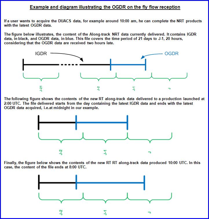