


Mesoscale Eddy Trajectory Atlas Product META4.0 DT
Types of dataset: multimission altimeter products.
DOI: 10.24400/527896/a01-2026.001 for META4.0exp DT allsat version - more metadata
Contents: multimission altimetry-derived eddy trajectories in version 4.0exp DT (for Delayed-Time) computed with the "all satellites" constellation maps (distributed by CMEMS).
Use: study of ocean mesoscale eddies
Condition of access: These products are available free of charge for any purpose (scientific, operational, commercial, etc.) as stated in the licence agreement.
Data access service: Https and FTP/SFTP, Thredds Data Server
Description: Anticyclonic and Cyclonic eddies detected from the multimission altimetry datasets, with their location, contours, amplitude, radius speed and associated metadata, for the whole altimetry period: 1993-ongoing
Geographic coverage: global
Format: NetCDF-4 Classic with CF standards.
Tools:
- User Handbook: Mesoscale Eddy Trajectory Atlas Product Handbook META4.0 DT, SALP-MU-P-EA-23760
- Use of the dataset, notebooks : https://py-eddy-tracker.readthedocs.io/en/stable/
- Code delivery: the open source code is available at https://github.com/AntSimi/py-eddy-tracker from version META3.0 onwards. When using the code, please cite "The code used to compute the Mesoscale Eddy Trajectories Atlas from version 3.0 onwards, was developed in collaboration between IMEDEA (E. Mason) and CLS, is freely available under GNU General Public License https://github.com/AntSimi/py-eddy-tracker ".
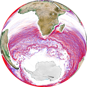
- Image of the month, June 2017: Eddies everywhere
Citation: If you use the data, please cite:: "The altimetric Mesoscale Eddy Trajectories Atlas (META4.0exp DT) was produced by SSALTO/DUACS and distributed by AVISO+ (https://aviso.altimetry.fr ) with support from CNES, in collaboration with IMEDEA (DOI: 10.24400/527896/a01-2026.001 for the META4.0exp DT allsat version)".
References:
- Gamot, J., Delepoulle, A., Nencioli, F., Pujol, M.-I., & Dibarboure, G. (2026). META4.0: a new mesoscale eddy network atlas derived from altimetry. preprint.
- Pegliasco et al., OSTST 2022: Monitoring the mesoscale eddies interactions with the altimetry constellation
- Pegliasco et al., OSTST 2022: A New Global Mesoscale Eddy Trajectories Atlas Derived from Altimetry : Presentation and Future Evolutions
- Pegliasco, C., Delepoulle, A., Mason, E., Morrow, R., Faugère, Y., Dibarboure, G., 2022. META3.1exp: a new global mesoscale eddy trajectory atlas derived from altimetry. Earth Syst. Sci. Data 14, 1087–1107. https://doi.org/10.5194/essd-14-1087-2022
- Mason, E., A. Pascual, and J.C. McWilliams, 2014: A New Sea Surface Height–Based Code for Oceanic Mesoscale Eddy Tracking. J. Atmos. Oceanic Technol., 31, 1181–1188, https://doi.org/10.1175/JTECH-D-14-00019.1
Copyright : 1993 - ongoing CLS - Cnes - IMEDEA
Eddy dataset
| Product | Satellite | DOI | Authenticated access service | Frequency | Data period | File weight |
|---|---|---|---|---|---|---|
| Merged version 4.0 delayed-time | allsat | 10.24400/527896/a01-2026.001 | HTTPS (without credentials) CNES AVISO FTP/SFTP access (with AVISO+ credentials):
CNES AVISO THREDDS Data Server access (with AVISO+ credentials): | yearly | From Jan 1993 to September 2023 | Cyclonic: 5.8 Gb Anticyclonic: 5.5 Gb |
See also
META 3.2 DT
META3.2exp NRT
META3.1exp DT (this version is not maintained anymore)
META3.0exp NRT (this version is not maintained anymore)
META2.0 DT (not recommended, this version is not maintained anymore)
Back to previous page
Data
- Products guide.
 Products .
- Sea surface height products .
- Value-added products .
- VENµS Level-2 Marine reflectances.
- ODATIS (MR) Level 3 - Basic.
- Simulated Level-2 ODYSEA dataset.
- Antarctic Circumpolar Current (ACC) - fronts product.
- Segmented images of meteocean processes.
- FSLE (Finite Size Lyapunov Exponents) .
- Global mesoscale eddy trajectory product .
- META4.0 DT.
- META3.2 DT.
- META3.2exp NRT.
- META3.1exp DT.
- META3.0exp NRT.
- META2.0 DT.
- Mediterranean 3D Eddies Atlas product.
- Sargassum detection products .
- Wind/wave products .
- Auxiliary products .
- Ice products .
- Ocean indicators products .
- Ocean data challenges .
- Tide Gauges products.
- Data access .
- Product information .
- CALVAL .