


Sargassum Floating Algae Index with Sentinel-3A&B and AQUA satellites.
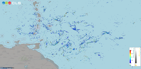
mats are shown in blue, cloud and land are shown in grey. Credits CLS.
Composite maps of sargassum detection index NFAI (Normalized Floating Algae Index).
Types of dataset: multimission dataset using OLCI instruments onboard Sentinel-3A&B satellites and MODIS instruments onboard AQUA.
DOI: 10.24400/527896/a01-2024.014 - more metadata
Contents: 7-day average of Sargassum Normalized Floating Algae Index (NFAI) using Sentinel-3A&B and AQUA satellites.
Use: study the seasonal variability of the sargassum presence in the Tropical Atlantic from Gulf of Guinea to Gulf of Mexico. Identify areas affected by Sargassum events and localize sargassum rafts.
Condition of access: these products are delivered for any purposes as stated in the licence agreement
Description: Daily gridded products provided in delayed time from February 2022 to a month before current date, made available as part of SeSaM SCO project (https://www.spaceclimateobservatory.org/sesam). Each map represents the sargassum presence (through normalized floatting alguae index) of the last 7 days at 0.01° resolution.
Citation: Any use of this dataset must be verified in the AVISO+ license and must cite its DOI 10.24400/527896/a01-2024.014 as well as the following sentence: "This 7-day average of Sargassum Floating Algae Detection product using Sentinel-3A&B and AQUA satellites was produced operationally by CLS in the frame of the SAMTool service, distributed by AVISO+ with the support of SCO-CNES."
Geographic coverage:: -100°W/13°E/-5°S/30°N
Format: NetCDF-4 Classic with CF standards.
Tools:
References:
- Gower, J., C. Hu, G. Borstad, and S. King, 2006: Ocean color satellites show extensive lines of floating sargassum in the Gulf of Mexico. IEEE Trans. Geoscience Rem. Sensing, vol. 44, n° 12
- Hu, C., 2009 : A novel ocean color index to detect floating algae in the global oceans. Rem. Sensing of Environment 113, 2118-2129
- Stum, J., Tebri, H., Sutton, M., and Granier, N., 2019: NRT satellite detection and drift forecast of sargassum algae in the Equatorial Atlantic, Poster presented at the IOCS meeting in Busan
- Wang, M., and C. Hu, 2016: Mapping and quantifying sargassum distribution and coverage in the central west Atlantic using MODIS observations. Rem. Sensing of Environment 18
Copyright : 2022 - ongoing, Cls
Sargassum Floating Algae Index - OLCI and MODIS
| Product | Satellite | DOI | Authenticated access service | Frequency | Data period | Dataset name |
|---|---|---|---|---|---|---|
| Sargassum detection - Floating Algae Index - OLCI and MODIS | OLCI instruments on Sentinel-3A&B and MODIS instrument on AQUA | 10.24400/527896/a01-2024.014 | see your MY AVISO+ | Daily | 2022/02/22 to one month delay | dataset-sargassum-merged-7day-olci-modis |
Data
- Products guide.
 Products .
- Sea surface height products .
- Value-added products .
- VENµS Level-2 Marine reflectances.
- ODATIS (MR) Level 3 - Basic.
- Simulated Level-2 ODYSEA dataset.
- Antarctic Circumpolar Current (ACC) - fronts product.
- Segmented images of meteocean processes.
- FSLE (Finite Size Lyapunov Exponents) .
- Global mesoscale eddy trajectory product .
- Mediterranean 3D Eddies Atlas product.
- Sargassum detection products .
- HR Coastal Sargassum Floating Algae Detection with VENµS.
- Sargassum Seasonal Forecast.
- Sargassum Floating Algae Index with AQUA satellite.
- Sargassum Floating Algae Index with Sentinel-3A&B and AQUA satellites (7-day average).
- Sargassum Floating Algae Index with Sentinel-2A&B and Landsat 8&9 satellites.
- Sargassum Floating Algae Index with Sentinel-3A&B satellites.
- Sargassum Floating Algae Index with GOES satellite.
- Wind/wave products .
- Auxiliary products .
- Ice products .
- Ocean indicators products .
- Ocean data challenges .
- Tide Gauges products.
- Data access .
- Product information .
- CALVAL .