


Use of altimetry water level time series by MSF to help displaced communities in South Sudan
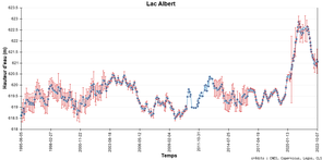
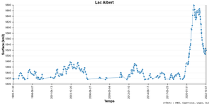
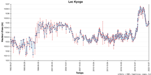
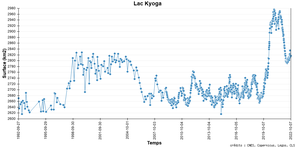
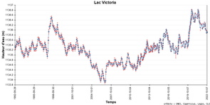
Heights and surfaces for the lakes Albert, Kyoga and Victoria, on the White Nile watershed. The increase of the surface for the past two or three years is major especially for lakes Albert and Kyoga. Even if a decrease has been noticeable for the past year, height and surfaces are still much higher than usual. (Credit Hydroweb)
Sudd wetlands are one of the largest wetlands on Earth. They are located in South Sudan, along the White Nile which flows from the Great Lakes (Victoria, Kyoga and Albert) towards the confluence with the Blue Nile. The Lakes Victoria, Kyoga and Albert have been at an exceptionally high levels these past two or three years, thus increasing the flow downstream. Some affluents are bringing even more waters to the marsh, like the Bhar-El-Gazal.
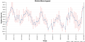
Height and surface for the River Bhar-El-Gazal, close to the town of Bentiu (Sentinel-3A measurements) (Credit Hydroweb)
")
South Sudan has been the theater of a civil war with Sudan from the 1970s to the early 2010s, when it gained its independence. There are still many problems, and a huge number of persons currently being displaced. Some of those people have taken refuge within the Sudd wetlands, where camps have been built to help them.
However, the very nature of the wetlands, and the hydrography of the region has led to repeated flooding of the camps. Doctors Without Borders (Médecins Sans Frontières) is involved in humanitarian relief there, in particular in the United Nations Mission in South Sudan (UNMISS) site to the north of the town of Bentiu, the largest site for displaced people in South Sudan. Determining the likelihood of flooding for both camps safety and integrity and for operations in the area is of foremost importance for them. Risks of waterborne disease epidemics, such as paludism, cholera or hepatitis E, in particular, are at their highest with such flooding.
However, no hydrographic in situ data are available in the whole South Sudan, very few upstream. Satellites such as the altimeters thus can help in warning of possible rise of the water level, if only by comparing with previous years, with also of course the input of precipitations (see precipitation anomaly map, left) on the upper branch of the rivers.
The Hydroweb data shown above are thus used to evaluate the situation and plan the next period. Swot should be able to help, but in several years when repeated observations from this mission will provide with normal / average values of its measurements in the region.
The monitoring of ocean/atmosphere phenomena such as the Indian Ocean Dipole, which seems to play a role in the extremes of the region could also be of help for (slightly) longer-term planning.
In 2022, above-average rains in most of South Sudan (but especially in the North) have been observed beginning in July, at the onset of the wet season. This leads to larger area flooded and even more people threatened (more than half a million, most of which in need of help for their whole life conditions, food and health included). Seasonal forecasts for the September to-November period show of a high likelihood of above-than-average rains for the North, increasing the problems.
For more information
- South Sudan: More than 150,000 people at risk following severe flooding in Bentiu (Doctors without borders)
- Climate: WFP at hand in South Sudan as floods threaten lives and livelihoods Situation Report - South Sudan (World food program)
- daily and weekly satellite precipitation data
- USGS early warning data over South Sudan


