


What is Aviso?
The job of Aviso in the Topex/Poseidon mission is to:
- produce and distribute mixed products from the French and American instruments,
- rapidly produce global quick-look products to promote the Topex/Poseidon system.
The Aviso/Eddie system
The Aviso/Eddie system at the CLS processing center is connected to the CTDP, also run by CLS, and the American Po-Daac center. It downloads processed data, IGDRs and GDRs from both centers. Aviso/Eddie also downloads the orbit files for the French and American instruments and the French geophysical corrections.
Our system has an electronic mailbox for quick distribution of Topex and Poseidon IGDRs to JVT teams selected by Cnes.
Aviso/Eddie products
During the Topex/Poseidon Verification Phase, the French and American ground data systems will produce IGDR-type altimeter data calculated using Cnes logistic orbits (Doris instrument), Nasa logistic orbits (TDRS data) and interim algorithms.
During the Observational Phase, the ground data systems will produce GDR-type altimeter data calculated from Cnes precise orbits (Doris) and Nasa precise orbits (laser telemetry). The algorithms used will be frozen after a calibration/validation review marking the end of the Verification Phase.
We have analyzed in detail the differences between the Topex GDRs (and IGDRs) and Poseidon GDRs (and IGDRs), and demonstrated the feasibility of mixed products, GDR-Ms (and IGDR-Ms). These will integrate the GDR-T (and IGDR-T) and GDR-P (and IGDR-P) data, with no losses.
Thanks to close cooperation with our American colleagues, we have defined this first-generation, single, mixed Cnes/Nasa product. The scientific community will be able to use and interpret the mixed data without specialist knowledge of how the onboard instruments work. However, the new product is not simply a temporal chaining of GDR-Ts and GDR-Ps, which would have been inconsistent for users. Our aim is to meet an identified scientific need: to assure continuity in the different GDR products over time, whichever altimeter is operating. The GDR-Ms were accordingly defined as follows
Certain parameters will appear twice in the GDR-Ms, for example two orbital radial heights and two ionospheric corrections. Parameters will be estimated whenever possible from two different calculations, i.e. different algorithms or input data, using TGS or SSDP methods of calculation for each instant of the altimeter measurement.
Topex sea-surface heights will be converted to altimeter heights to include a single parameter in the GDR-Ms.
Indexes common to Topex and Poseidon will be redefined.
Empty fields will be included so that parameters such as ocean tides can be introduced later on using new algorithms, models or data.
However, unlike Seasat (but in common with Geosat) the 10-Hz Topex/Poseidon altimeter measurements are included in the GDR-Ms: researchers have pointed out that simply analyzing measurements averaged over a second can eliminate actual signals.
In addition to quality control by the CTDP and TGS on the basic Topex and Poseidon GDRs, we have made a special effort on quality control of the mixed product. Before we distribute data to the community concerned, Aviso will do three levels of control:
level-1 to display simply, for each cycle, the geographical distribution of the altimeter data on a world map. The Topex and Poseidon data can be plotted separately or as a complete set.
level-2 displays for each cycle the distribution of some physical quantities in the altimeter record. Processing consists of calculating histograms, for each geographical region, of each selected quantity and displaying them together for each area on a world map.
level-3 is done at crossover points. This extracts the altimeter data at the crossover points and displays the distribution of crossover discrepancies for each 10-day cycle as a histogram and rms value.
How you will receive Aviso/Eddie products
During the first six months of the Topex/Poseidon mission we will distribute these products and quality control results to the PIs and co-Is selected by Cnes, about 100 researchers. We will then continue to distribute throughout the Observational Phase but the system will be open to the entire scientific community. Researchers will be welcome to request the standard products described below.
Distribution media
Topex/Poseidon products will be distributed on CD-Roms (Compact Disk Read Only Memory). During the Verification Phase Cnes PIs and co-Is will receive a CD every ten days by mail. The disk will contain an IGDR-M cycle and the file of crossover points generated by level-3 quality control, i.e. a total of around 300 MB of data. During the Observational Phase Cnes PIs and co-I's will receive a CD-Rom every 20 days with two consecutive cycles of GDR-Ms and the files of crossover points (around 600 MB). There will also be a map showing the geographical distribution of the altimeter data generated by level-1 quality control. Every two months the French Calval bulletin will report on the quality of the products, and will include a selection of level-2 output quality control.
Distribution lead time
During the Verification Phase PIs and co-Is will be sent products from a data cycle on the 13th working day after the end of the cycle. Production will begin with cycle 1, at the end of September 92.
During the Observational Phase PIs and co-Is will be sent products from two cycles on the 41st working day after the end of the second cycle. The production lead time is longer due to calculating the precise satellite orbit.
User information
Before production starts PIs and co-Is will receive a handbook describing the products. All new users may also request a copy.
A few figures: during the Topex/Poseidon mission we shall be sending PIs and co-Is some 360 Terabytes of information on 10,000 CD-Roms.
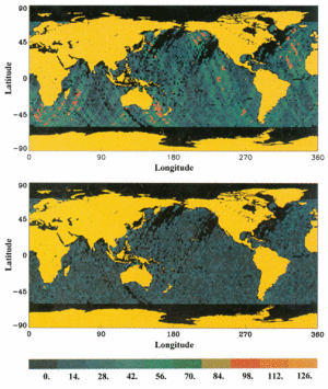
Standard deviation of discrepancies at crossover points on a 2° latitude by 2° longitude grid for Geosat cycle 25. GEMT-T orbit before (top) and after (bottom) error calculations.
Aviso quick-looks
The Aviso Quick-look project aims to rapidly demonstrate the innovative nature of the Topex/Poseidon mission by releasing results 3, 6, 9 and 12 months after the launch. This will give the scientific community and general public varied examples of mission applications. Quick-look activities will be based mainly on the work done by Cnes and Nasa PIs and co-Is. To make their work easier and faster to accomplish, the CLS Space Oceanography Group has developed a Topex/Poseidon data pre-processing system as part of Aviso. This will regularly provide Cnes PIs and co-Is with validated, pre-processed data and will output some of the global products.
Aviso/Quick-look processing system
The input to the Quick-look system will be (I)GDR-P, (I)GDR-T and (I)GDR-M data supplied by Aviso/Eddie. The first step is validation. Ocean data with rms 1-second discrepancies (sH) below a given threshold will be selected first. Validation will then consist of calculating discrepancies with respect to an existing mean surface, i.e. threshold rejection; detection will also be tuned by a spline function.
The second step is correcting orbital error. The system will perform global minimization of the discrepancies at crossover points, cycle by cycle, using the method put forward by Tai and Fu (1986) and Tai (1988), namely constrained adjustment of sinewaves. The main orbital error frequencies, in particular at one cycle per revolution, will be fitted to one or more revolutions to minimize the discrepancies at crossover points. The figure above shows the results obtained with this method (one-cycle- and two-cycles-per-revolution sinewaves fitted over one revolution) using Geosat data, GEMT-2 orbit.
A simplified file will then be created on each cycle, containing the track number, latitude, longitude, height corrected for orbital and geophysical errors, orbital error, H1/3 and s0. PIs working on Quick-looks will be able to receive (by electronic mail) the file either in global form or after extraction of geographical areas. Residuals relative to a cycle or mean will be calculated from a set of n files corresponding to n cycles (n>2). A file of residuals (track number, cycle number, latitude, longitude, residual height) for all cycles concerned will be created and made available to PIs as global or geographical products.
The Quick-look processing system will also provide along-track global maps of the topography and slope (or geostrophic velocity) signal rms variability, plus spectral analyses of sea level anomaly (wavenumber and frequency/wavenumber spectra). Other Aviso/Eddie and Calval outputs which could be useful for the Quick-look project include: estimation of orbital noise and error; global along-track maps, per cycle, of the geophysical corrections, significant wave heights (H1/3) and magnitude of wind speed; histograms and spectra for the geophysical corrections; and mapping of the ionospheric content calculated from Doris data.
Quick-look products from Cnes PIs and co-Is
PIs and co-Is will mainly contribute during the preliminary analyses of Topex/Poseidon data which they perform in their own research projects. While coordinating Cnes PI and co-I activity, starting in summer 1991, we listed a number of Quick-look products which could be obtained during the year following the launch. The PIs will be fully involved with promotional activities and will of course retain the intellectual property rights to their results. The products are briefly described in the table below.
Nasa PIs and co-Is are also providing Quick-look products.
Conclusion
Quick-look products will be available to a broad audience, from the scientific community to the general public. Quick-look products will also be very useful for the scientific altimetry community as they provide an immediate evaluation of Topex/Poseidon data and should help to stimulate further research. The first Quick-looks should be ready around two months after the launch, in the form of product data sheets of one or two pages. These will be the more basic products, obtained from the first month of data. We plan to produce a video tape showing the initial results at the end of 1992. Aviso Newsletters in 1993 will include new results. Once a full year of measurements have been made, we will release a brochure describing the results so far, and a longer video.
| Person in charge | Product | Lead time |
| C. Le Provost | Tide signal in English Channel | 1 month |
| A. Cazenave | Overlaying mean Topex/Poseidon track on existing mean surface | 1 and 3 months |
| S. Arnault | Large-scale altimeter maps and comparison with models of Tropical Atlantic | 3 months |
| P. De Mey | Comparison of Topex/Poseidon data in North-East Atlantic with assimilated ERS-I fields | 3 months |
| J.M. Lefèvre | Comparison of altimetric H 1/3 and with models (Mediterranean and North Atlantic) | 3 months |
| J.F. Minster | Monitoring strong altimetric signals (rivers) | 4 months |
| C. Périgaud | Global altimetric variability (20 days to 100 days) | 4 months |
| C. Le visage | Monitoring mesoscale structures in North-East Atlantic | 4 months |
| C. Périgaud | Monitoring mean level and transport of main currents in Indian and Pacific Oceans | 4 months |
| P. Vincent | Altimeter calibration/validation from Lampedusa | 4/5 months |
| J. Picaut | Comparison with drifting buoy data and currentmeter moorings in Tropical Pacific | 6 months |
| M. Gründlingh | H1/3 in Agulhas current | 6 months |
| S. Arnault | Preliminary study of waves in Tropical Pacific | 7 months |
| P. Mazzega | Maps of main ocean tides by global inversions | 7 months |
| C. Millot | Analysis of Algerian eddies from ERS-1 and Topex/Poseidon. Comparison with AVHRR measurements | 7 months |
| P. Queffeulou | Sea state and storm surges in North Atlantic | 6 months/l year |
| Y.H. Park | Variability of Antarctic Circumpolar Current in Crozet basin | 6 months and June 93 |
| A. Cazenave | Adjusting long wavelengths of mean sea surfaces to Topex/Poseidon profiles | 6 months/l year |
| C. Provost | Screen animation of Brazil/Falklands confluence region | 7 months |
| J. Verron | Assimilation of Topex/Poseidon altimeter data in model of North Atlantic | 7 months |
| P. Vincent | Animation of tide solutions in Pacific and Antarctic Circumpolar Current | 9/12 months |
| J. Verron | Assimilation of Topex/Poseidon altimeter data in a PE model of confluence region | 12 months |
| J. Verron | Special issue of Oceanologica Acta (JASO meeting) | End of 1992 |
| S. Arnault | Comparison of Topex/Poseidon data with Cither experiment data | April 1993 |
| P. Tarits | Comparison of Topex/Poseidon data with Babas station in Canary basin | July 1993 |
| J. Picaut | Accurate validation of altimetric sea level in open ocean | July 1993 |
| C. Le Visage | Comparison of Topex/Poseidon data with Sémaphore-93 data | August 1993 |