


Focus on Topex/Poseidon
The French-American Topex/Poseidon mission is at the heart of the World Ocean Circulation Experiment, Woce. It consists of a satellite dedicated to ocean observations and centers to process the data.
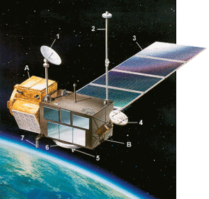
A - MMS multimission platform
B - Instrument module
1/Data transmission TDRS
2/Global positioning system antenna
3/Solar array
4/Microwave radiometer
5/Altimeter antenna
6/Laser retroreflectors
7/Doris antenna
Objectives of Topex/Poseidon
The ocean plays a major role in climatic variations, transporting mass and heat and absorbing excess CO2. If we are to understand it better, we need realistic models derived from observations gathered on a global scale. Satellite observation plays a major role in this, thanks to its unrivaled space-time sampling and the use of common sensors.
Satellite observations are central to the international Woce program. Altimetry is particularly important, as it provides the sea-surface topography from which surface currents can be deduced.
Topex/Poseidon is expected to determine sea level basinwide with monthly-averaged precision and accuracy on the order of 2 cm.
The ocean signal has a broad space-time spectrum which can be split into:
- a turbulent component: variations in major western boundary currents, eddies, rings, with spatial signatures of 10 to 500 km and temporal variations of a few days to a few years,
- a large-scale component with seasonal and interannual variations of a few centimeters over spatial scales of a few thousand kilometers, the size of an ocean basin. Tidal components with amplitudes of around 10 cm are overlaid on the signal.
Topex/Poseidon is optimized to investigate large-scale phenomena which are the most difficult to achieve from a technical viewpoint but the most significant for climatology. It will measure surface slope variations on the order of a centimeter in 10,000 km.
The turbulent mesoscale component, equally significant in energy terms, will be measured with great precision. Topex/Poseidon should ultimately produce the first estimates of the global variability of the oceans.
As soon as the project was decided on, Cnes and Nasa examined a large number of proposals. Some 200 research scientists were selected: 38 Principal Investigators (PIs) from nine countries and their co-Investigators (co-Is). This community has made major contributions to the definition of the Topex/Poseidon project and in particular to defining the processing algorithms and the models to be developed.
The main research themes are to:
- study the general ocean circulation and its variability, and its interaction with the atmosphere on a global scale or on the scale of ocean basins,
- study circulation on regional scales over periods of a few months to a few years,
- conduct statistical studies of mesoscale variability to enhance global circulation models. Such models cannot describe mesoscale phenomena, and therefore depend on statistical characterizations,
- observe eddies in certain ocean areas. Some of the work is to predict circulation on temporal scales of a month in areas of around 1000 km square,
- model tides. A better description of the tides will not only increase understanding of tidal energy dissipation for geophysicists but will also provide better corrections of the altimeter topography measurements,
- study surface waves, their response to wind forcing and interaction with currents,
- enhance knowledge of the gravity field and the geoid by using data from satellite tracking systems to analyze orbital perturbations,
- study the geophysics of the marine geoid by analyzing altimeter measurements or accurately locating ground beacons. These studies are intended to enhance our understanding of the lithosphere and the earth's crust.
How Topex/Poseidon will help to determine ocean circulation
There are several steps in determining ocean circulation by altimetry. Some use the measurement itself, and the corrections, to yield the ocean topography; others convert from topography to circulation by removing terms thought to be perturbations.
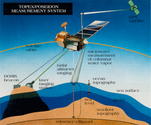
The altimeter is actually a radar which measures the range from the antenna to the sub-satellite point by emitting pulses and measures the round-trip propagation time. This provides the satellite-to-earth range to within a few centimeters. By analyzing the shape of the return pulse, significant wave height and magnitude of wind speed can be deduced. Regular internal calibration by the altimeter corrects for instrumentation errors.
Signal propagation through free electrons in the ionosphere can create errors of 2 to 25 centimeters in the range measurement, and must be corrected. Similar corrections must be made to remove tropospheric error (propagation through the atmosphere: 2 m; water vapor effect: 0 to 40 cm). Electromagnetic bias due to the reflection of the radar pulses off the waves can reach several centimeters depending on swells and sea states. It can be modeled from measurements of the significant wave height and the wind.
The satellite position in a terrestrial reference frame at each instant is calculated by processing the data from one or more orbit determination systems.
All these results are combined to yield sea-surface height at the sub-satellite point relative to a reference ellipsoid at a given instant. The ocean circulation signal can then be calculated by subtracting:
- the height of the geoid relative to the reference ellipsoid. For a repeat-track satellite such as Topex/Poseidon, this correction is not necessary for determining the variability of the circulation,
- ocean and solid earth tides.
For the geoid and tides, research areas in their own right, Topex/Poseidon simply provides a correction factor for each altimeter measurement. Nor does it provide a correction factor for effects due to variations in atmospheric pressure, regarded today as an ocean signal and not needing correcting.
Topex/Poseidon satellite and orbit
The Topex/Poseidon satellite, mass of around 2400 kg, was built by the American Fairchild Corporation. It will be launched in August 1992 by a European Ariane 42P launcher supplied by Cnes. Its expected useful lifetime is three to five years.
The orbit is optimized for a global ocean circulation mission. Its altitude of 1336 km is high enough to limit atmospheric drag effects and remove some of the irregularities in the earth's gravity field but low enough to supply the necessary sensor accuracy. The 66° orbital inclination provides coverage of 90% of the ocean. The repeat period is 10 days: the satellite revisits each point on the earth, to within a kilometer, every 10 days and can thus study temporal variability. The distance between successive tracks, i.e. in the grid pattern formed by the points observed, is on the order of 310 km at the Equator. The local time of successive passes shifts by two hours, often thought to be an advantage as it helps to isolate tide effects.
Payload
Altimeters
The main instrument carried by Topex/Poseidon is the Nasa altimeter. By operating simultaneously on 5.3 and 13.6 GHz it corrects ionospheric error, which is frequency-sensitive. Cnes is also flying a miniaturized-altimeter, Poseidon, for technological qualification. It will also operate on 13.6 GHz and will use the same antenna. Poseidon will operate around 10% of the time.
Orbit determination systems
Probably the trickiest task for a global mission like Topex/Poseidon is determining satellite altitude. The distance from the satellite to terrestrial reference positions must be known to within 10 cm-and within a few centimeters would be better.
To provide maximum information on the orbit, the errors and their spectra, Topex/Poseidon will carry three tracking systems, all accurate to within 10 cm:
- Laser Retroreflector Array (LRA) on the satellite. Nasa will use the array with ground-based lasers to track the satellite and to calibrate and verify altimeter height measurements,
- Doris, Cnes' precise orbitography system, using measurements of the Doppler shift on two ultra-stable frequencies (2036 and 401 MHz) transmitted by a network of 50 Orbit Determination Beacons (ODBs) on the ground. Doris has been tested and provided good results on the French remote sensing satellite Spot-2. The Doris measurements will also be fed into a mathematical model to calculate the ionospheric corrections for the altimeter measurements,
- an onboard Global Positioning System (GPS) receiver, supplied by Nasa, for validation.
Radiometer
Nasa is also supplying a microwave radiometer to measure the natural radiation received from the area under the satellite in three channels: 18, 21 and 37 GHz. This can be used to deduce the quantity of water vapor vertically below the satellite path. The wet tropospheric effect affecting altimeter measurements can thus be corrected to within a centimeter.
Ground data systems
The Topex/Poseidon payload operates continuously. The Nasa/JPL TGS control center in California monitors satellite health, uplinks commands and receives telemetry via the American Tracking and Data Relay System (TDRS).
The raw data from the two French instruments is extracted and transmitted daily with the auxiliary data (radiometer data, satellite health and attitude) to the French ground data system, the SSDP, at Cnes in Toulouse. Within the SSDP is the Doris-Poseidon Control Center, the CTDP, operated and run by Cnes subsidiary CLS. The CTDP preprocesses the data, does the scientific processing, monitors the French instruments, and generates the work program and the commands. The Doris Orbitography Department at Cnes calculates the precise satellite ephemeris from the Doris measurements.
The TGS and SSDP ground data systems use Topex and Poseidon measurements respectively to produce their own Geophysical Data Records (GDRs). These two geophysical data products integrate altimetric measurements, the corrections described above, output by different algorithms, and the precise orbital ephemeris. The precise orbit will not be available during the first six months of the mission, the Verification Phase. Determining the precise orbit will need a gravity field model matched to the satellite orbit-but the model will itself need calculating from the first three months of measurements by the onboard orbit determination systems. During this phase the ground data systems will produce Interim GDRs (IGDRs) calculated from Nasa and Cnes logistic orbits using interim algorithms. These IGDRs will then be reprocessed into GDRs in the following six months of the Observational Phase.
Topex GDRs produced by the TGS contain the sea surface height above the ellipsoid, the significant wave height, backscattering coefficients, standard environmental corrections, and the satellite height above the ellipsoid as derived from the NASA orbital calculation. The Poseidon GDRs from the SSDP will be similar. However, the algorithms and record contents differ from Topex in certain respects, in particular:
- the ionospheric correction is calculated from Doris measurements instead of the dual-frequency radar altimeter measurements used for Topex GDRs,
- the orbital radial height for the Poseidon GDRs is generated from Cnes precise ephemeris calculations,
- the Poseidon GDRs contain the altimeter measurement itself and not the sea surface height.
A few figures:
The Poseidon radar altimeter will send 100 million useful echoes to the ocean, ice and deserts every day.
After compression on board the satellite this represents 10 MB of telemetry a day. The final Poseidon GDRs represent some 18 MB a day.
The total volume archived at the SSDP including intermediate storage will be around 250 MB.
Calibration
Verification activities are commensurate with the performance expected of the observation system, namely 2 cm on the altimeter measurement, around 10 cm on the absolute measurement of sea level, 2 m/s on wind speed and 50 cm on wave height. Cnes and Nasa are to validate the data through the Joint Verification Plan (JVP). The main activities are:
- in situ verification, to calibrate the altimeter measurement locally relative to an equivalent external measurement deduced from in situ sea level observations and laser tracking measurements. Cnes has selected Lampedusa island in the Mediterranean as the nominal verification site. (Nasa is to use the Harvest oil rig off California.) Topex/Poseidon will overfly Lampedusa every ten days. It will be instrumented for accurate calibration of the instruments, namely tide-gauges, lasers, buoys, ground radiometers, Doris beacons, etc.
- statistical analyses to verify globally the internal consistency of system parameters. These analyses will be based partly on Aviso products (histograms) and on comparisons with external models. A Topex/Poseidon processing system has been set up at CLS to do this.
- regional verification experiments by teams of scientists working on Topex/Poseidon. More than 15 teams have offered to participate in this validation effort, which includes experiments in the Mediterranean, off the coast of Great Britain, in the North Sea, in the equatorial Pacific and the Semaphore experiment in the North-East Atlantic. This "scientific" validation will harmoniously complement Cnes' and Nasa's Calval calibration/validation activities.
The main objective common to all these activities is to evaluate all the components of the Topex/Poseidon system, from the raw altimeter measurement through to the final sea level product, including the geophysical corrections applied to the altimeter measurement (performance level, estimation and characterization of errors). Validation work will be particularly intense during the first six months of the mission, at the end of which routine GDR production will start. However, continuous quality control will be done throughout the mission.
All the significant results will be presented and discussed with users at regular working meetings. They will also be published in the Calval bulletin which Aviso will distribute every two months to all Topex/Poseidon users. The bulletin will include samples of the statistical results obtained as well as a diagnostic sheet for each system component, in particular:
- instrumentation noise level, based on along-track analyses and discrepancies at crossover points,
- altimeter bias and drift as deduced from in situ verification at Lampedusa,
- analysis of discrepancies at crossover points for different choices of geophysical corrections before and after global minimization (to reduce orbit error),
- error levels and spectral characteristics of tropospheric corrections (comparison of TMR and ECMWF values) and ionospheric correction (by comparing Topex correction with Doris correction),
- evaluation of electromagnetic bias by analyzing consistency at crossover points. An initial relationship will be supplied after four months, then refined in the following months,
- validation of wind and altimeter wave products by comparisons with meteorological models. A relationship between the backscattering coefficient and the wind will be supplied after the first six months,
- intercalibration of the Topex, Poseidon and ERS-1 altimeters, essentially by in situ experiments and statistical analyses.
CLS is contributing to the Topex/Poseidon project in the following ways:
- Cnes has asked CLS to design and run the Doris-Poseidon Processing Center (CTDP), part of the French ground data system for the Topex/Poseidon mission.
- Cnes asked the CLS Space Oceanography group and the GRGS to develop the French Calibration/Validation (Calval) program for Topex/Poseidon. CLS is in charge of producing global statistical evaluations for the altimeter products. CLS is also involved in defining and validating the altimeter processing algorithms.
- CLS participated in developing Aviso/Eddie and is responsible for operating it. CLS is also in charge of developing the Aviso Quick-look system. This will supply scientists with processed altimeter data in the shortest possible time and will provide global products for promoting Topex/Poseidon.