


Mercator, forecasting the ocean
Mercator Ocean has been created with an ambition : describe and forecast in real time and at any moment the ocean on a global scale, on the surface of the ocean and in its depths.
Partners and international cooperation
The Public Interest Group (GIP) Mercator Ocean was founded in April 2002 with a brief from its six member organisations (Cnes, CNRS, Ifremer, IRD, Météo France et Shom). From 2010, Mercator Océan is a non profit company, owned by 5 Major French Agencies : CNRS, Ifremer, IRD, Météo France et Shom. Founding member of Mercator Océan, the French Spatial Agency (Cnes) is today a key-partner.
Today, the project has an european dimension as part of GMES, to become the heart of a central European operational oceanography: Mercator Océan coordinates the MyOcean project since 2009.
Finally, Mercator Ocean is the french contribution to the international Godae experiment, which federates, compares and validates all valid existing projects in ocean forecasting.
Observe, understand, predict
At the heart of the Mercator forecasting system, mathematical models and physical laws describe the ocean's 4 dimensions: horizontal dimensions, vertical dimension (depth) and temporally dimension (up to 14 days).
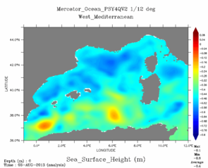
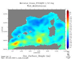
Sea surface height for T0 (left, 2013/078/03) and forecasting for T+7 (right, 2013/08/09) from Mercator high resolution bulletin at 1/12°.
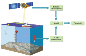
To make prediction models as reliable as possible, we have to assimilate a large volume of frequently updated measurements. These measures come from satellite observations, but also from in situ observations.
Satellite altimetry is a precious aid for observing the oceans. Altimetric measurements of sea surface height mirror what is happening from the ocean floor to the surface, allowing us to chart ocean circulation and to determine wave heights and wind speed. Altimetry satellites such as Jason-1 give us rapid access to the high-quality data needed for weather and ocean forecasting, and for climate prediction.
While only the surface properties of the ocean are accessible to satellite observations, data assimilation from in situ observations are needed to improve the consistency between the satellite data and model simulations, to dynamically interpolate and extrapolate heterogeneous measurements and to better exploit the results of observations.
Large-scale international programmes such as Argo are now taking shape to provide the widest possible coverage of the oceans by in-situ instruments, to complement spaceborne programmes.
Several products for wide applications
The main application areas covered by Mercator are environment, safety, climatology and seasonal weather forecasting, physical and biogeochemical oceanography, sustainable use of fishing resources, off-shore, marine routing, ocean racing, ...
Further information :
- Dossiers : Predicting currents, forecasting the ocean (pdf, 2,11 Mo).
- Image of the month, January 2001 : Mercator takes oceanography into the future.
- Newsletter n° 8, 2001 : Mercator, Forecasting Global Ocean P. Bahurel et al. (pdf, 360 Ko).
- external website : Mercator Ocean, Initiation to operational ocean forecasting