


Processing for Coastal and Hydrology products (Pistach)
Pistach products encompass Coastal and Hydrology products : Jason-2 along-track Level-2 (global areas) and Level-3 (few areas). The input consists of Jason-2 Level 2 S-IGDR altimeter products. The products include new retracking solutions, several state-of-the-art geophysical corrections as well as higher resoluti
Waveform retracking
The effective footprint of a pulse-limited altimeter is controlled by the pulse bandwidth and by the width of the analysis window (corresponding to the number of gates of the altimeter waveforms). Over water, after the leading edge of the altimeter pulse strikes the sea surface, the area illuminated by the pulse becomes a circle that expends with time until the trailing edge of the pulse reaches the calm sea surface a time later. Thereafter, the area illuminated by the short pulse becomes an expending annulus spreading on the earth surface (See Pulses and waveforms).
In the case of land/sea or sea/land transitions, the altimeter footprint can be partly over ocean and partly over land (see Figure). Consequently, the power received by a radar antenna in each of its sampling gates, is linked to the relative proportion of sea and land surfaces in the corresponding annulus and also to the relative sigma naught coefficients of each of these surfaces.
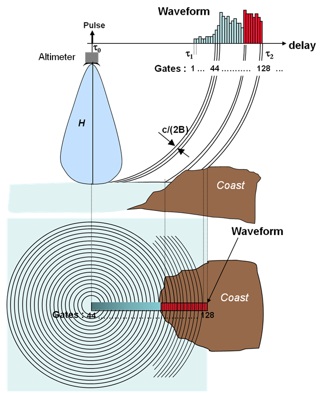
The top panel of the figure shows how, when the nadir of the satellite is still over ocean (during an ocean to land transition for example), the last samples of the waveform are contaminated by land returns. The closer the satellite nadir position is from the coastline, the more the last samples of the waveforms are contaminated. Similarly, during a land to sea transition, the closer the satellite nadir position is from the coastline, the more the returns from ocean cells contaminate the last samples of the waveform.
The lower panel of the figure is a view of the altimeter footprint showing the importance of the relative ocean and land surfaces in each of the annulus foot-prints. The number of contaminated gates depends on the height and areal extent of the land, as well as its proximity to the nadir point. Moreover, how the waveform is affected depends on a weighted average of the scattering coefficient of land and ocean i.e. “SurfaceLand x sigma0Land” relative to “SurfaceOcean x sigma0Ocean” where SurfaceLand (respectively SurfaceOcean) is the surface of land (resp. Ocean) in the altimeter footprint.
If sigma0Land < sigma0Ocean (often true), the effect will be small. In some environments however (coral atolls), sigma0Land > sigma0Ocean and the land effect is significant.
From this, it is clear that the geometry of the coastline, the relief, the nature of the terrain, all characteristics of the coast that are extremely diverse all over the world, will all contribute to the shape of the waveform. An equivalent reasoning can be done for hydrologic surfaces.
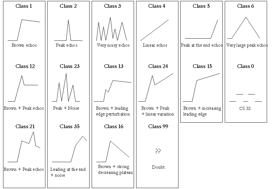
In order to account for these various waveforms shapes, dedicated retracking algorithms are required to precisely estimate the altimetric range and, if possible, the other waveform parameters. The retracking strategy involves a classification of the waveforms, plus the application of four different retracking algorithms, in order to provide users with several possibilities and enable them to choose the most appropriate one for their case.
Waveforms are classified according to their shapes: Brown echoes (for ocean and ocean-like surfaces); peak echoes, linear, very noisy, etc. A number is assigned to each class, and included as a flag in the dataset, thus enabling users to automate their processing, for example by using a different retracking output depending on the class.
Coastal applications
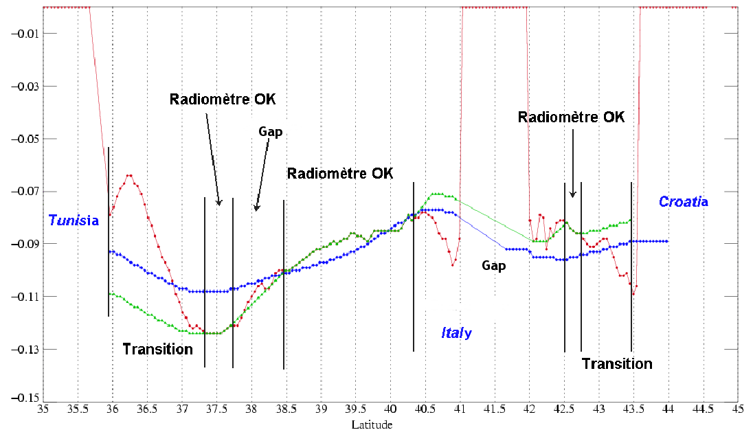
Two different wet tropospheric corrections are implemented in the experimental coastal products:
- A composite correction, whereby the model correction (ECMWF) replaces the radiometer near the coasts (<50 km), or the ECMWF correction is shifted to the nearest valid radiometer value in the transition case. Interpolation and detrending are also applied in complex cases.
- A decontamination correction, probably more suitable than the composite correction for areas where large and rapid fluctuations of air masses are observed, the composite correction being too smooth. On the contrary, decontamination may be less precise over areas with complex shorelines.
A study was performed in order to assess the performances of empirical estimation of regional Sea State Bias (SSB) models. Three zones were selected: the Mediterranean Sea, Bay of Biscay and Gulf of Maine, because they represent different types of sea state regimes (dominated by young seas, short or long fetch etc.). Different SSB models were obtained on the three zones. It was shown that such estimations performed on very small regions are too affected by the oceanic signal, which prevents the real sea-state bias being retrieved. The PISTACH products will use the SSB model of Jason-2 GDR products.
Hydrology
The hydrology altimetry products are enriched with state-of-the-art geophysical parameters (geoid, DEM, land cover class, Land/water mask, etc.).
The wet tropospheric correction, crucial over continental waters, cannot be computed from the onboard radiometer because the land emissivity drowns out the signal coming from water bodies. The model backup correction included in the standard altimetry products has proved to be insufficiently accurate over continental waters.
A new wet tropospheric model correction is developed, based on a more accurate integration of the atmospheric parameters. Moreover, over land, the ECMWF model geometry does not reconstruct small-scale topography, especially over water bodies in mountainous terrains.
Data
- Products guide.
 Products .
- Data access .
- Product information .
- Aviso+ user handbooks.
- Data format.
- Citation and Aviso+ products licence.
- Information about mono and multi-mission processing .
- Processing steps and data levels.
- Ssalto : mono-mission processing .
- Ssalto/Duacs multimission altimeter products .
- Specific processing .
- Processing for Coastal and Hydrology products (PISTACH).
- Updates and reprocessing .
- CALVAL .