La Niña comes and goes
Image of the Month - January 2026

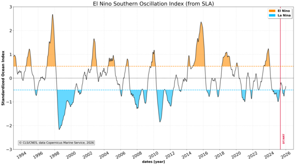
For the second year in a row, the Tropical Pacific is experiencing a La Niña episode this winter. It is expected to be short and weak, similar to last year's, with a 75% probability of returning to neutral conditions in spring. The following events are still in balance, between neutral and El Niño, with a new La Niña being less likely.
The El Niño–Southern Oscillation (ENSO) phenomenon, of which La Niña is considered as the "negative" phase, is monitored using a number of techniques, including satellites. Among these satellites, altimetry satellites play a key role. Given the breadth of the phenomenon, which encompasses the entire Tropical Pacific (i.e. about half the circumference of the Earth), satellites are uniquely suited to monitor it. Altimetry, in particular, can detect an upcoming El Niño or La Niña quite early in their development by observing the large-scale ondulations of the ocean (Rossby waves).
Over the years, specific areas have been identified as the most effective locations for observing the development of ENSO phenomena (the "Nino1", "Nino2", "Nino3", "Nino4" and "Nino3.4" boxes). Aviso has been proposing an indicator computed from altimetry in the 'Nino3.4' box for a number of years, and this has now been upgraded. The latest update shows the current La Niña, which is not as impressive as some of the past ones, but is definitely present.
See also:
- Applications: ENSO
Data: ENSO indicator
Other website on this topic:
- WMO press release
- Noaa Climate prediction center (monitoring and forecasts)
- International Research Institute ENSO Forecast page


