


Topex/Poseidon Orbits
The orbit configuration was chosen to optimise the study of temporal large-scale ocean variability and avoid aliasing different tidal constituents to the same frequency.
A high orbit altitude was also selected to minimise atmospheric drag and gravity forces acting on the satellite, and to make orbit determination easier and more accurate.
On 15 September 2002 Topex/Poseidon assumed a new orbit midway between its original ground tracks. The former Topex/Poseidon ground tracks are now overflown by Jason-1. This tandem mission demonstrated the scientific capabilities of a constellation of optimised altimetry satellites.

T/P on its new orbit, situated at one half the Jason-1 track spacing. Cycle 369, which began on Friday 20 September 2002, was the first full cycle in the new orbit. Download Google Earth file to visualise <media 13049 - download>Jason-1</media> and T/P ground tracks.
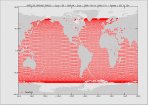
The exact altitude enabling the orbit to satisfy these constraints and fly over two verification sites located in the Mediterranean Sea (Lampedusa Island, Italy) and at the Harvest oil rig platform (California, USA) was 1 336 km. An inclination of 66° was selected - i.e. the inclined orbit sampled from 66° north to 66° south - so as to cover most of the world's oceans (~ 90%). The orbit was non-sun-synchronous and prograde. A repeat period of 9.916 days was chosen (ie; the satellite passed vertically over the same location, to within 1 km, every ten days) as the best compromise between spatial and temporal resolutions. The distance between successive tracks was of the order of 315 km at the equator. The local time of successive passes shifted by nearly two hours per cycle.
A satellite orbit slowly decays due to air drag, and has long-period variability due to the Earth's heterogeneous gravity field, solar radiation pressure, and other lesser forces. Periodic manoeuvres are therefore required to keep the satellite on its orbit. The frequency of these manoeuvres depends primarily on the solar flux affecting the Earth's atmosphere, but there is generally expected to be one manoeuvre (or series of manoeuvres) every 40 to 200 days. The process usually takes from 20 to 60 minutes. Manoeuvres should wherever possible be performed at the end of a 10-day cycle, preferably when the satellite is overflying land in order not to disrupt precise orbit determination. Science data are not acquired when orbit maintenance manoeuvres are being performed.
Orbit parameters
| Main characteristics | |
|---|---|
| Semi-major axis | 7714.4278 km |
| Eccentricity | 0.000095 |
| Argument of perigee | 270.8268° |
| Inclination (non-sun-synchronous) | 66.039° |
| Auxiliary data | |
| Reference altitude (equatorial) | 1,336 km |
| Nodal period | 6,745.72 seconds (112'42" or 1h52') |
| Repeat cycle | 9.9156 days |
| Number of passes per cycle | 254 |
| Ground track separation at Equator | 315 km |
| Acute angle at Equator crossings | 39.5° |
| Longitude at Equator of pass 1 | 99.92° 98.51° since Sept. 2002 |
| Orbital velocity | 7.2 km/s |
| Ground scanning velocity | 5.8 km /s |