


Sensors onboard Topex/Poseidon
To be useful for studying ocean circulation, especially at gyre and basin scales, numerous improvements have been made with Topex/Poseidon relative to previous altimetric systems (Seasat, Geosat), including specially designed satellite, sensor suite, satellite tracking systems, and orbit configuration, as well as the development of an optimal gravity model for precision orbit determination and a dedicated ground system for mission operations.
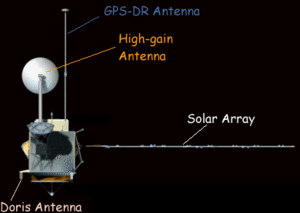
The Topex/Poseidon satellite is an adaptation by Fairchild Space of the existing Multimission Modular Spacecraft (MMS) which has successfully carried the payload of the Solar Maximum Mission, Landsat 4 and Landsat 5. The MMS design was modified to meet the Topex/Poseidon requirements: a 2400 kg mass carrying six science instruments - four operational and two experimental - described as follows :
| Nom | Type | Origine | Produits |
|---|---|---|---|
| NRA (Topex) | Nasa radar altimeter | Nasa opérationnel | Altimeter range Significant wave height Wind speed modulus Backscatter coefficient Ionospheric correction |
| SSALT (Poséidon-1) | Solid state radar altimeter | Cnes expérimental | Altimeter range Significant wave height Wind speed modulus Backscatter coefficient |
| TMR | Topex microwave radiometer | Nasa opérationnel | Brightness temperature Water vapor content Liquid water content |
| LRA | Laser retroreflector array | Nasa opérationnel | Precise orbit ephemeris (*) |
| Doris | Doppler tracking system receiver | Cnes opérationnel | Precise orbit ephemeris (*) Ground beacon precise positioning Ionospheric correction |
| GPSDR | Global positioning system <br/> demonstration receiver | Nasa expérimental | Precise orbit ephemeris |
* Altimetric measurements are referred to geodetic coordinates by means of a precise orbit determination system. Both precise orbit determination teams use the combination of LRA and Doris tracking data, one operated by Cnes and one by Nasa.
Dual-frequency Nasa Radar Altimeter (NRA)
NRA or Nasa Radar Altimeter (206 kg including redundancy, 237 W), operating at 13.6 GHz (Ku band) and 5.3 GHz (C band) simultaneously is provided by Nasa. It is the fifth generation of altimeter; its design is based on the previous SEASAT and GEOSAT altimeters with significant improvements including the 5.3 GHz channel for the ionospheric measurement. It is the primary sensor for the Topex/Poseidon mission. The measurements made at the two frequencies are combined to obtain the altimeter height of the satellite above the sea (satellite range), the wind speed modulus, the significant wave height and the ionospheric correction.
Further information on the NRA.
Three-frequency Topex Microwave Radiometer (TMR)
The TMR (50 kg including partial redundancy, 25 W) measures the sea surface microwave emissivity (brightness temperatures) at three frequencies (18, 21 and 37 GHz) to provide the total vapor content in the troposphere along the altimeter beam. The 21 GHz channel is the primary channel for water vapor measurement. The 18 and 37 GHz channels are respectively used to remove the effects of wind speed and cloud cover (liquid water contribution) on the water vapor measurement. Measurements are combined to obtain the error in the satellite range measurements caused by pulse delay due to water vapor and to obtain the sigma naught correction for liquid water absorption.
Further information on the TMR.
Laser Retroreflector Array (LRA)
The LRA or Laser Retroreflector Array (29 kg) reflects laser signals from a network of 10 to 15 ground laser tracking stations (Satellite Laser Ranging stations, SLR) to provide tracking data for precise orbit determination and the altimeter bias calibration.
Further information on the LRA.
Dual-frequency Doppler tracking system receiver (Doris)
Doris or Doppler Orbitography and Radiopositioning Integrated by Satellite (43 kg including redundancy, 21 W) is a French system that uses a two-channel receiver (401.25 MHz and 2036.25MHz) to observe the Doppler signals from a network of about 50 ground transmitting beacons. It provides all-weather global tracking of the satellite for precise orbit determination. Doris beacons are equipped with meteorological sensors measuring temperature, humidity, and atmospheric pressure to correct for atmospheric effects on the transmitted signals. The Doris signals are transmitted at two frequencies to allow the removal of the effects of ionospheric free electrons on the tracking data as well as the altimeter signals.
Further information on Doris.
Single frequency Solid State radar ALTimeter (SSALT)
SSALT also called Poseidon-1 validates the new technology of a low-power (49W), light-weight (23 kg without redundancy) altimeter for future Earth observing missions. It is provided by the French Space Agency (Cnes). It shares the same antenna as the NRA; thus only one altimeter operates at any given time. It operates about 10% of the time, or one cycle over ten.
SSALT operates at a single frequency of 13.65 GHz (Ku band). Measurements give the same geophysical information as NRA's. However since this sensor uses a single frequency, an external correction for the ionosphere must be supplied (see the Doris instrument).
Further information on the SSALT.
Global Positioning System Demonstration Receiver (GPSDR)
The GPSDR (28 kg without redundancy, 29 W), operating at 12227.6 MHz and 1575.4 MHz, receives signals from up to 6 GPS satellites. The GPS antenna is mounted on a long boom to reduce multipath effects which can severely corrupt the measurements.
These satellite data plus tracking of GPS from ground sites allow nearly geometrical solutions. Precise tracking of the satellite is made possible by using the technique of Kalman filtering and a new GPS differential ranging technique.
Further information on the GPSDR.