Hurricane Melissa observed over ocean by satellites
Image of the Month - November 2025

See also the animation of the whole Hurricane Melissa track
Hurricane Melissa was the thirteenth named storm, the fifth hurricane, and the third to reach Category 5 on the Saffir-Simpson scale during the 2025 hurricane season in the North Atlantic Ocean.
A tropical atmospheric disturbance that originated in West Africa traveled to the Caribbean Sea on October 16, 2025 and became the tropical storm Melissa on October 21. Melissa rapidly intensified into a major hurricane on October 25 and reached Category 5 on October 27, just south of Jamaica. Wind speeds averaged 295 km/h, with gusts reaching 360 km/h, and the minimum pressure at its center was 892 hPa.
On October 28, Melissa crossed western Jamaica at its maximum intensity, causing extensive damage from wind, rain, and storm surge. The Caribbean Sea's warmth, which was nearly one degree above seasonal averages, most likely fueled this rapid intensification. Some of the damage can also be attributed to the storm's relatively slow speed, which meant it remained in one place for a longer period of time. The hurricane continued northeastward and struck southeastern Cuba as a Category 3 storm in the early hours of October 29. It then passed over the Bahamas and the Turks and Caicos Islands as a Category 2 storm. From October 30 to 31, it passed west of Bermuda.
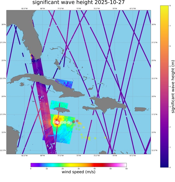
Altimeter measurements, including those from Swot, show significant wave heights of over 8 meters on October 27 and 29 around the phenomenon (measurements were not necessarily taken directly under the hurricane).
Sentinel-1 wind measurements reached 70 m/s (sustained wind, with stronger gusts) on October 27, when the hurricane made landfall in Jamaica.
Thanks to these types of measurements, weather model forecasts for such phenomena can be improved. Starting in November 2025, Level 2 Swot measurements should be provided more quickly (within 2 days instead of 4 to 5 days). Currently, measurements from operational nadir altimeters are provided within 2 hours for weather monitoring. Since the release of the first Swot data, the algorithms for calculating significant wave height data have been improved thanks to subsequent studies.
See also:
- Missions: Swot
- Applications: cyclones, typhoons and hurricanes
- Data: Swot L2 and L3


