



Using Mean Dynamic Topography for elevation leveling on lands
Image of the Month - November 2026
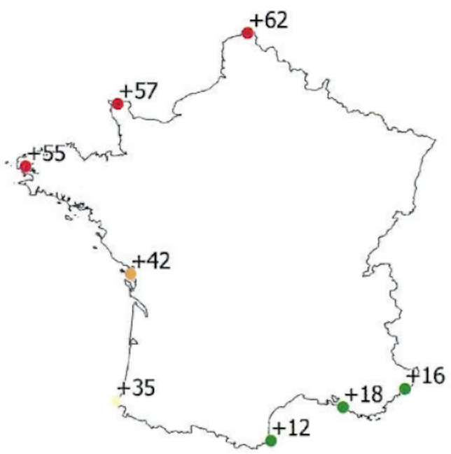
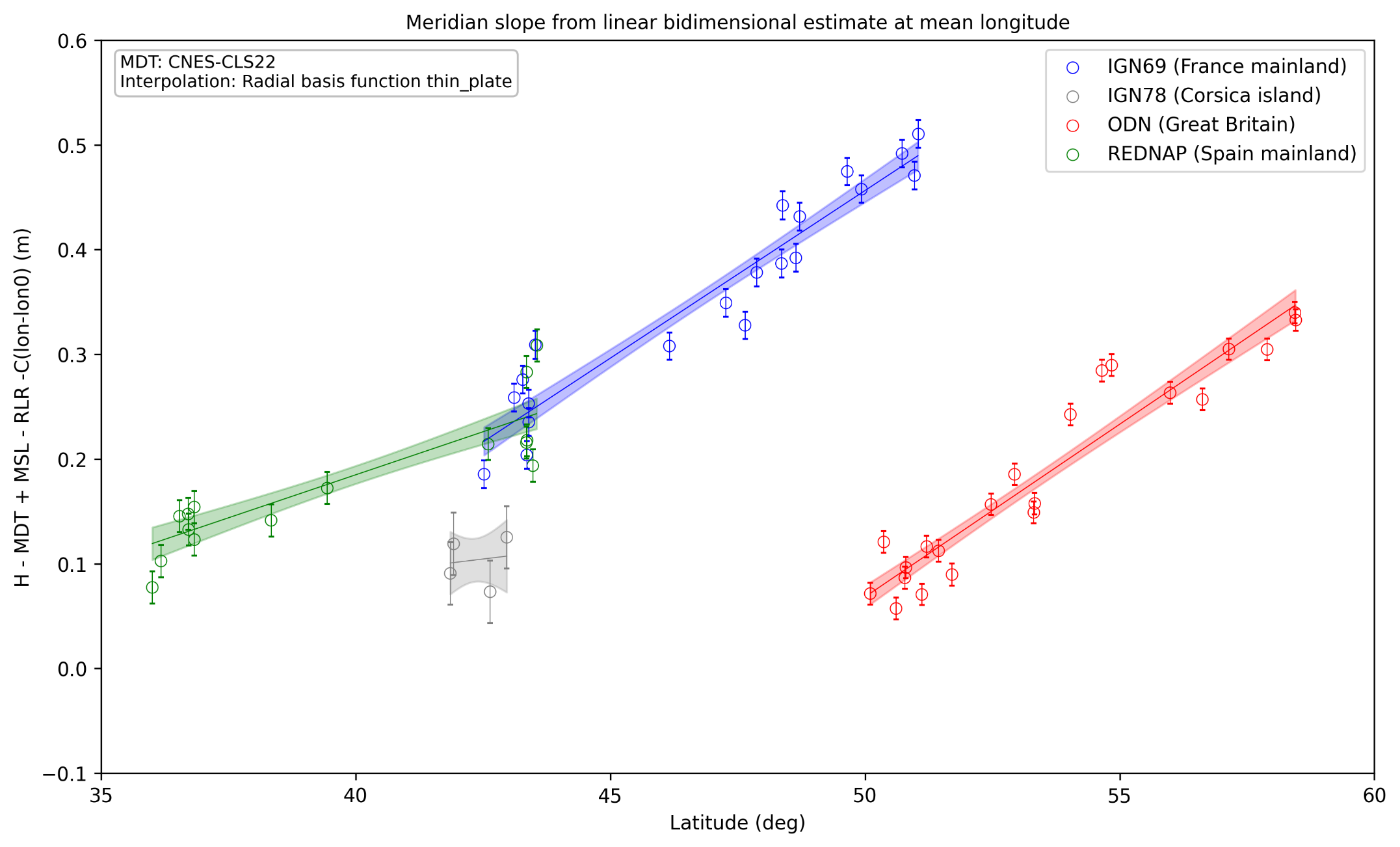
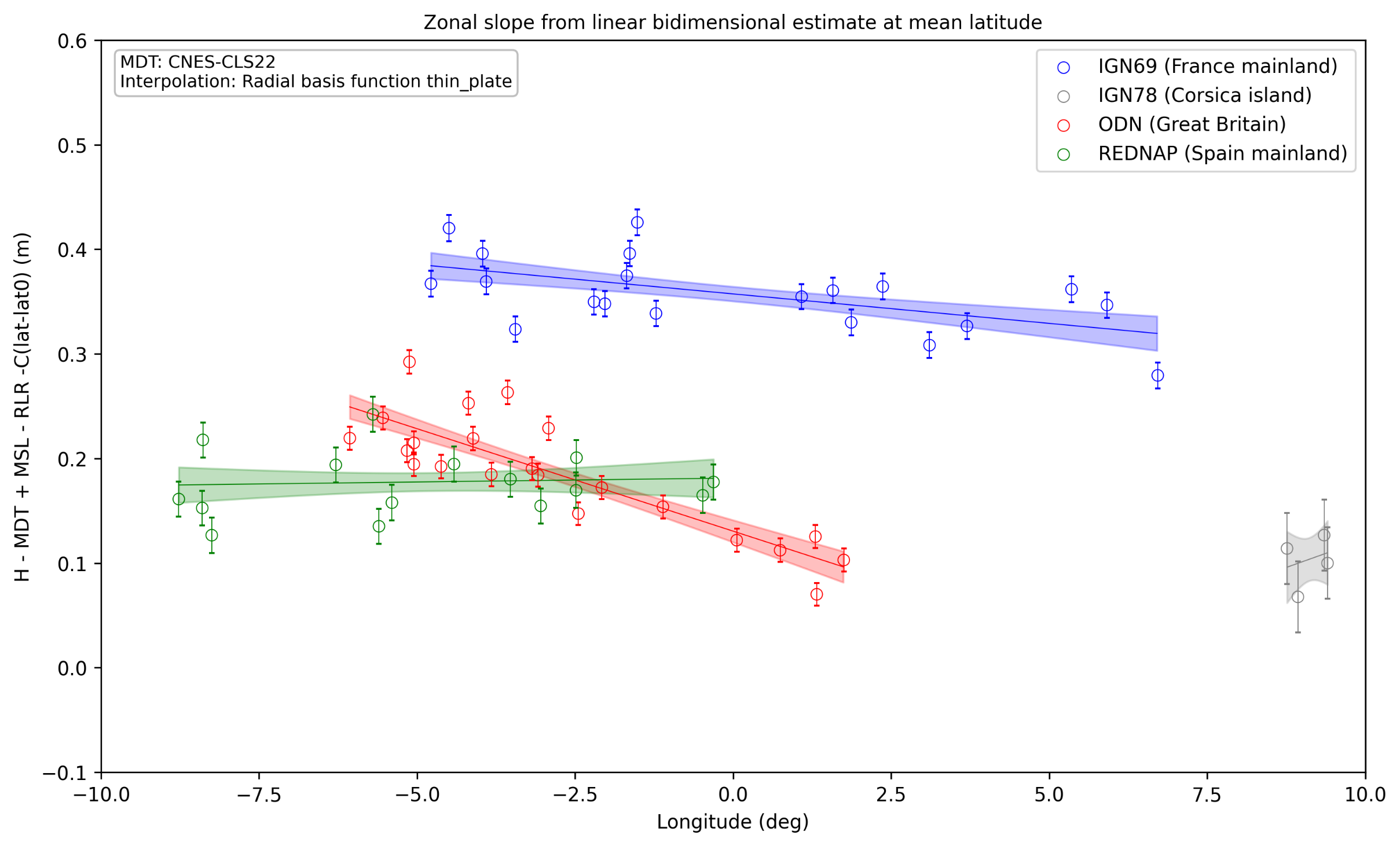
Altitudes on lands are expressed with respect to a reference surface that has to realize as good as possible an equipotentiel of the gravity field; historically, this one was accessed through a temporal mean of sea level derived from observations at, at least, one point per country, following the resolution of the first General Assembly of the International Association of Geodesy, held in 1862 in Berlin. This is why you can "gain" or "loose" several centimeters or even tens of centimeters in altitude in one step by just crossing a border. In (mainland) France, the reference is the Marseille tide gauge over the period 1885-1896. From that point, using land surveyor techniques such as spirit leveling, the "zero" was propagated from place to place, reaching the other coasts of the country, some around 1000 km away - and not by the Mediterranean Sea like Marseille, but by the Atlantic Ocean, English Channel or North Sea. For neighboring countries the principle can be the same - a given point as reference (e.g. Newlyn in Great Britain, Alicante in Spain mainland, etc), propagated over their whole territory. For islands, with no land in between to propagate the measurements, a dedicated similar reference has to be chosen, for instance Ajaccio between 1912 and 1937 in Corsica.
This technique, while highly accurate at the local level, may be prone to systematic errors over long distances, leading to a zero surface not horizontal -- e.g. Dunkerque, on the North Sea, nearly 900 km north of Marseille is 25 cm higher with respect to that altitude zero than it should. The other obvious one is the historical discrepancies between neighboring countries, and the impossibility of having the same zero of altitude on an island, even when in the same country. Moreover, when defining the "level of the sea" as zero, the mean dynamic topography was not considered, since not known at first, then not measurable anyway. Nevertheless, scientific leveling surveys and intercomparison studies with neighboring countries, conducted by the IGN (National Geographic Institute), have initiated an assessment of the horizontality of the elevation system for mainland France.
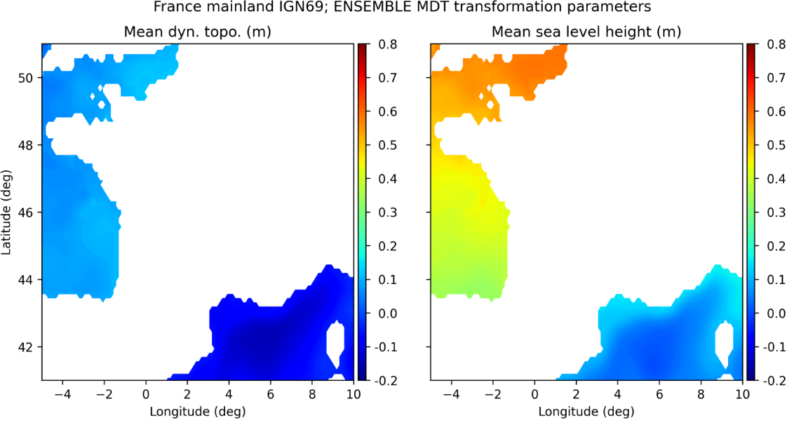
For the past years, however, we have had mean dynamic topography data, computed from altimetry Mean Sea Surface, a geoid, drifting buoys and temperature/salinity profiles. It enables to remove mean dynamic topography from the "level of the sea", and thus reference the zero of altitudes to the geoid used in the mean dynamic topography computation, something which can be done on all coastal regions. Referencing the zero of altitude to a geoid using Mean Dynamic Topography can be a way of having an international -- at least for countries with a coast --, and also overseas uniform reference. It is also important in coastal sea level rise vulnerability assessment.
See also:
- Applications: Large-scale ocean circulation
- Image of the Month, February 2003: Ocean currents
- Image of the Month, March 2023: A new Mean Dynamic Topography released
- Data / Auxiliary: MDT - MDT-CNES-CLS22 or MDT-HYBRID-CNES-CLS22-CMEMS2020 (with Mediterranean and Black Seas)
References:
- Jonathan Chenal et al., Unifier les références verticales terre-mer par nivellement hydrodynamique pour exprimer les projections climatiques dans les références altimétriques légales, Journées Refmar 2026, Brest, France, 22-24 September 2026
- J. Chenal et al., Towards land and sea vertical unification thanks to hydrodynamic levelling
Symposium of the IAG Subcommission for Europe (EUREF), Paris, France, 23-25 June 2026
News
 Archives .
- Aviso Newsletter .
- Search.
- Front-page news.
- Image of the month .
- 2026 .
- Nov. 2026: Using Mean Dynamic Topography for elevation leveling on lands.
- Oct. 2026: Mediterranean Sea seasons from submesoscale measured by Swot.
- Aug. 2026: Classifying sea ice leads and floes in Swot data.
- Jul. 2026: El Niño 2026: altimetry reveals similarities with the extreme event of 1997.
- Jun. 2026: FSLEs help in modelling marine floating debris accumulation.
- May 2026: Swot captured the vortex merger chronology in the Lofoten Basin.
- Apr. 2026: Sediment moves in the Ganges-Brahmaputra delta, measured by Swot.
- Mar. 2026: Microplastics distribution in the ocean influenced by eddies.
- Feb. 2026: Swot helps in assessing the tides in estuaries and rivers.
- Jan. 2026: La Niña comes and goes.
- 2025 .
- 2024 .
- 2023 .
- 2022 .
- 2021 .
- 2020 .
- 2019 .
- 2018 .
- 2017 .
- 2016 .
- 2015 .
- 2014 .
- 2013 .
- 2012 .
- 2011 .
- 2010 .
- 2009 .
- 2008 .
- 2007 .
- 2006 .
- 2005 .
- 2004 .
- 2003 .
- 2002 .
- 2001 .
- 2000 .
- 1999 .
- 1998 .
- Operational news and status .


