Combined mean dynamic topography - MDT CNES-CLS22
Types of dataset: auxiliary products
DOI: 10.24400/527896/a01-2023.003 - more metadata
Contents: The Mean Dynamic Topography MDT-CNES-CLS22 is an estimate of the mean over the 1993-2012 period of the sea surface height above geoid. This is consistent with the reference time period also used in the SSALTO DUACS products.
Use: ocean circulation, operational oceanography
Description: use of the latest GOCO06S geoid model (based on the complete GOCE mission fully reprocessed and 14 years of GRACE data) and 30 years of altimetry and in-situ data (hydrologic, drifters and High Frequency radar on a limited area). (More information)
Geographic coverage: global, 1/8°
Distribution media: Authenticated FTP, gridded data extraction tool and Thredds Data Server (TDS).
Condition of access: The MDT-CNES-CLS22 is a standard product as stated in the licence agreement. Please see our FAQ to access this product (distinction if you are already an Aviso+ user or not).
Copyright: 1992-ongoing Cnes-CLS
References:
- Solène Jousset, Sandrine Mulet, Eric Greiner, et al. New Global Mean Dynamic Topography CNES-CLS-22 Combining Drifters, Hydrological Profiles and High Frequency Radar Data . ESS Open Archive . December 03, 2023. DOI: https://doi.org/10.22541/essoar.170158328.85804859/v1
- Jousset S., Mulet S., Wilkin J., Greiner E., Dibarboure G. and Picot N.: “New global Mean Dynamic Topography CNES-CLS-22 combining drifters, hydrological profiles and High Frequency radar data”, OSTST 2022, https://doi.org/10.24400/527896/a03-2022.3292.
- Image of the month March 2022: a new mean dynamic topography released
MDT
| Product | Authenticated access service | type | format | File weight |
|---|---|---|---|---|
| MDT-CNES-CLS22 | access via MY AVISO+ and select the product "MDT_CNES_CLS (Global Mean Dynamic Topography)" | gridded | NetCDF4 | 48 Mb |
Releases of previous MDT
MDT-CNES-CLS18
All information about this MDT can be found in a dedicated page.
MDT_CNES-CLS13 improvements are:
- In the computation of the first-guess:
- use of the geoid model EGM-DIR-R4 based on 2 years of reprocessed GOCE data and 7 years of GRACE data
- use of the CNES-CLS11 Mean Sea Surface
- improvement of the filtering process
- optimal filter at around 125 km (instead of about 400 km)
- In the combination with oceanic in-situ data:
- updated dataset of drifting buoy velocities (1993-2012) and carefully preprocessed to take into account drogue loss and corrected for wind slippage in this case
- Improvement of Ekman model to extract the geostrophic component of the buoy velocities (parameters fitted over the 1993-2012 period, by longitude, latitude and month) and computation of an Ekman model at 0m (used for undrogued boys) and at 15m depth (used for drogued boys)
- updated dataset of dynamic heights (1993-2012) computed from Temperature/Salinity profiles from CORA3.4
Comparison between MDT CNES-CLS13 and MDT09 can be found in a dedicated page.
Details about MDT CNES-CLS13 can be found here.
CNES-CLS09_v1.1
Contents: mean of the 1993-1999 period sea surface above geoid, corrected from geophysical effects. The MDT_CNES-CLS09 is an estimate of the ocean MDT for the 1993-1999 period. The MDT for a different time period P can be easily deduced using altimetric Sea Level Anomalies referenced to the 1993-1999 period with : MDTP=MDT93-99+<SLA93-99>P. The Ssalto/Duacs multimisson (M)ADT products from the Duacs 2014 (V15.0) are computed with a new MDT referenced over a twenty-year period [1993-2012] which doesn't correspond to this MDT CNES-CLS09.
Description: based on 4.5 years of GRACE data, and 15 years of altimetry and in-situ data (hydrologic and drifters data). (More information).
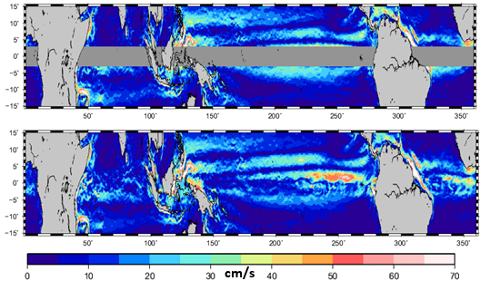
The strongest changes with the CNES-CLS09_v1.0 concern the mean velocity estimate in the equatorial band: due to the failure of the geostrophic approximation near the equator, no velocity estimates were given in the CNES-CLS09_v1.0 release for the [-3°,3°] latitudinal band. A specific work has been done to estimate the mean velocities at the equator.

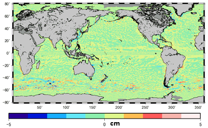
The height differences between the two releases is small with a global mean difference of -0.02 cm and a rms difference of 0.05 cm.

CNES-CLS09_v1.0.
Compared to the previous RIO05 field, the main improvements are:
- The use of the recent EIGEN-GRGS.RL02.MEAN-FIELD based on 4,5 years of GRACE data
- The use of an updated dataset of drifting buoy velocities(1993-2008)and dynamic heights(1993-2007)
- The use of an improved Ekman model to extract the geostrophic component of the buoy velocities
- The use of an improved processing method of the dynamic heights allowing to make use of T/S profiles to different reference depths.
- Estimation was done on a 1/4° resolution grid(instead of 1/2° for RIO05).


