


Sea salt seen by altimeters
Image of the month - August 2003
The sea has salt in it, of course, but how much? Salinity (which includes not only the salt you put in your food, but every type of salt dissolved in the water) has not yet been measured by satellites. While awaiting the future missions, Smos (Esa) and Aquarius (Nasa), we can still estimate this by means of altimetry and temperature measurements. Since salinity along with temperature, determines the water density, it thus has an impact on ocean circulation (effects on sea surface height can reach 6 cm).
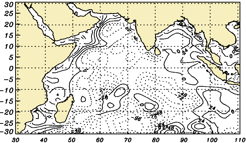
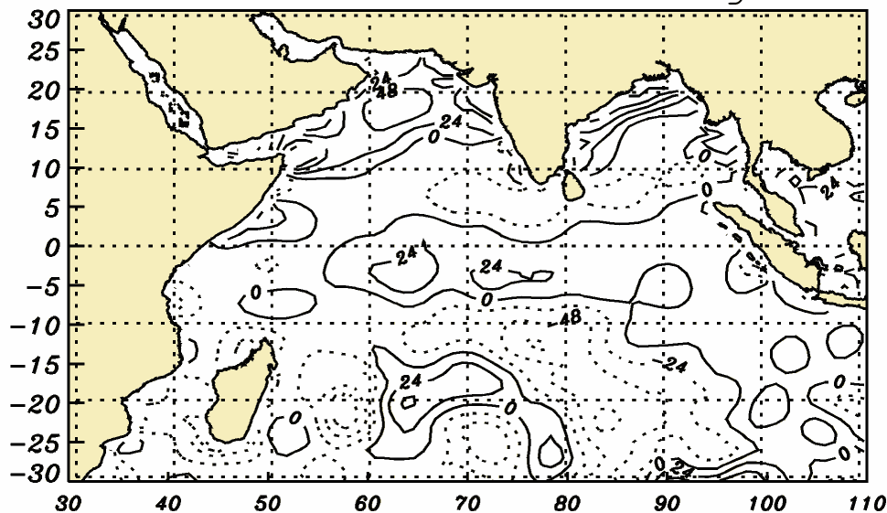
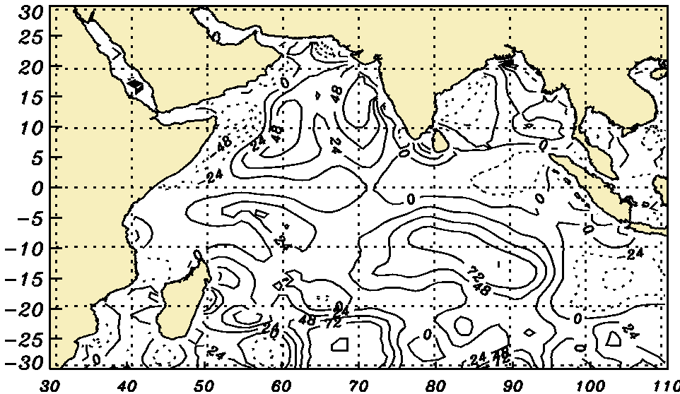
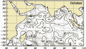
Salinity deduced from data measured over the Indian Ocean (mean over 8 years, in kg/m2), in January (winter monsoon, dry -- see Image of the Month for October 2002: Summer current, winter current), April, July (summer monsoon, wet) and October. Salinity increases with evaporation, and decreases with rains and runoff. It does not increase much in summer in the Bay of Bengal (East of India), into which many rivers flow, whereas the salinity of the Arabian Sea increases strongly during the same period.
(Credits Bulusu Subrahmanyam & James. J. O'Brien, Center for Ocean-Atmospheric Prediction Studies, Florida State University, USA)
Salinity can have important consequences, especially on the formation of El Niño phenomena. Differences in salinity are one of the reasons (along with temperature) that stratify the ocean into layers that do not mix. In the Tropical Pacific, a salinity layer acts as a frontier. Depending on its position, the ocean surface layer, in which mixing occurs, is more or less deep,. and the less deep it is, the more heat is stocked in a 'small' water volume, thus increasing surface temperature.
Websites on this subject:
- Smos (Esa)
- Aquarius (Nasa/GSFC)
- The pinch of salt which influences El Niño onset (IRD)
References :
- Shi W., B. Subrahmanyam, J.M. Morrison, 2003: Estimation of heat and salt storage variability in the Indian Ocean from Topex/Poseidon altimetry, J. Geophys. Res., 108 (C7), 7-1 to 15.
- Maes, C. and D. Behringer, 2000: Using satellite-derived sea level and temperature profiles for determining the salinity variability: A new approch, J. Geophys. Res., 105 (C4), 8537-8547.
News
 Archives .
- Aviso Newsletter .
- Search.
- Front-page news.
- Image of the month .
- 2026 .
- 2025 .
- 2024 .
- 2023 .
- 2022 .
- 2021 .
- 2020 .
- 2019 .
- 2018 .
- 2017 .
- 2016 .
- 2015 .
- 2014 .
- 2013 .
- 2012 .
- 2011 .
- 2010 .
- 2009 .
- 2008 .
- 2007 .
- 2006 .
- 2005 .
- 2004 .
- 2003 .
- Dec. 2003: Warm waters.
- Nov. 2003: Aral Sea: nothing new under the Sun.
- Oct. 2003: Black Sea forecasting.
- Sep. 2003: Scaling the waves.
- Aug. 2003: Sea salt seen by altimeters.
- Jul. 2003: Currents steered by gaps in the ridges.
- Jun. 2003: Combining sensors.
- May 2003: Flying tandem.
- Apr. 2003: A looping current.
- Mar. 2003: Africa's Great Lakes.
- Feb. 2003: Ocean currents.
- Jan. 2003: Altimetry and phytoplankton.
- 2002 .
- 2001 .
- 2000 .
- 1999 .
- 1998 .
- Operational news and status .