


Water flowing under the ice
Image of the month - June 2007
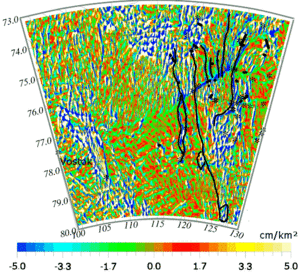
Ice surface topography curvature map in the area between Lake Vostok and Dome C in Antarctica. Black lines show the hydrological network detected under the ice that links the small sub-glacial lakes in the area (marked with stars).
(Credits Legos)
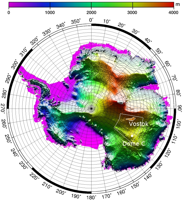
Over the ice, as over the ocean, surface topography can mirror what happens underneath, at the "bottom". Lake Vostok (Image of the Month, August 2000, A lake capped by ice), for example, under more than 3,000 m of ice, forms a plateau on the Antarctic surface. Other, smaller, signals can also be extracted from this topography, especially from the high-resolution one measured by ERS-1 during its geodetic phase.
Curvature can be deduced from the topography measured by altimetry. This highlights the irregularities of the ice grounds, and ice flow anomalies. Between Lake Vostolk and Dome C (where the French-Italian Concordia base is), we can see linear, elongated, features that seem to link the numerous lakes discovered in this area. Other clues, like the fact that these features follow the slope of the bedrock, lead to think that they are sub-glacial hydrological networks linking the lakes between each other.
The fact that such hydrological networks exist is important to understand Antarctica and the way ice are flowing on this continent. Altimetry contributes to this knowledge of the biggest iced terrestrial water stock.
See also:
- Applications: Ice
References:
- F. Remy, B. Legresy, Subglacial hydrological networks in Antarctica and their impact on ice flow, Annals of Glaciology, 39, 2004
News
 Archives .
- Aviso Newsletter .
- Search.
- Front-page news.
- Image of the month .
- 2026 .
- 2025 .
- 2024 .
- 2023 .
- 2022 .
- 2021 .
- 2020 .
- 2019 .
- 2018 .
- 2017 .
- 2016 .
- 2015 .
- 2014 .
- 2013 .
- 2012 .
- 2011 .
- 2010 .
- 2009 .
- 2008 .
- 2007 .
- Dec. 2007: What will next season be like?.
- Nov. 2007: The ocean is going up and down around the Solomon Islands.
- Oct. 2007: South Atlantic Anomaly as seen by Doris.
- Sep. 2007: Altimetry on eddies' tracks.
- Aug. 2007: Altimetric views of a typhoon.
- Jul. 2007: Cruising speed measurements.
- Jun. 2007: Water flowing under the ice.
- May 2007: Turns of the seasons in the Ocean.
- Apr. 2007: Discovering a current in the 21st century.
- Mar. 2007: Malaria and altimetry in the Amazon.
- Feb. 2007: Ierapetra gyre pops in and out.
- Jan. 2007: El Niño on time for Christmas.
- 2006 .
- 2005 .
- 2004 .
- 2003 .
- 2002 .
- 2001 .
- 2000 .
- 1999 .
- 1998 .
- Operational news and status .