FES2022 (Finite Element Solution) - Global tide
Types of dataset: auxiliary products
DOI: 10.24400/527896/a01-2024.004 - more metadata
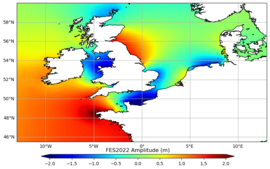
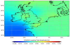
Contents: The FES2022 tides database include 2 components: tide elevations (amplitude and phase) and tide loading (amplitude and phase) on a 1/30°x1/30° grid.
- Tide elevations: FES2022b ocean tide model is distributed; this model has been computed using the new FES2022 tidal loading grids.
Two versions are available:- Non extrapolated version: the model is defined on a 1/30° grid directly interpolated from the finite element native grid of the model.
- Extrapolated version: the above version has been extrapolated on the coasts in order to cover nearly entirely the coastal regions. The procedure is explained in the user manual. The mask is also delivered.
- Tide loading: the new FES2022b tide loading must be used to compute the FES2022b geocentric (elastic) tide as follows:
FES2022b geocentric (elastic) tide = FES2022b oceanic tide + FES2022b loading tide.
Use: coastal oceanography, operational oceanography, ocean circulation
Description: the product is based on a hydrodynamic model which assimilates some altimeter data and a few tide gauges. Details are given in Carrere et al., OSTST 2022.
Citation: "The FES2022 Tide product was funded by CNES, produced by LEGOS, NOVELTIS and CLS and made freely available by AVISO". CNES, 2024. FES2022 (Finite Element Solution) Ocean Tide (Version 2022) [Data set]. CNES. https://doi.org/10.24400/527896/A01-2024.004"
Geographic coverage: global
Format: NetCDF 4
Distribution media: FES2022 Tidal Currents is not distributed at the moment. We cannot give you a specific date for its distribution. However, you will be informed of any updates on this status.
Condition of access: FES2022 Tidal Currents is not distributed at the moment. We cannot give you a specific date for its distribution. However, you will be informed of any updates on this status.
File weight: max 170 MB for one height elevation file, max 240 MB for one load file and 750KB for the mask.
References and tools:
- FES2022 User manual
- Carrere et al., OSTST 2022: A new barotropic tide model for global ocean: FES2022,
https://doi.org/10.24400/527896/a03-2022.3287 - Florent H. Lyard, Loren Carrere, Ergane Fouchet, Mathilde Cancet, David Greenberg, Gérald Dibarboure and Nicolas Picot: “FES2022 a step towards a SWOT-compliant tidal correction”, to be submitted to Ocean Sciences.
Copyright: 2022- ongoing Legos/Noveltis/Cnes/CLS
Previous version
FES2014
Types of dataset: auxiliary products
Contents: The FES2014 tides database includes 3 components: tide elevations (amplitude and phase), tide currents (u and v) and tide loading on a 1/16°x1/16° grid.
- Tide elevations: FES2014b ocean tide model is distributed; this model has been computed using the new FES2014 tidal loading grids.
Two versions are available:- Non extrapolated version: the model is defined on a 1/16° grid directly interpolated from the finite element native grid of the model. Folder is fes2014_elevations_and_load/fes2014b_elevations/
- Extrapolated version: the above version has been extrapolated on the coasts in order to cover nearly entirely the coastal regions. The procedure is a simple extrapolation applied on 10 pixels and using mean values when necessary, it can be not enough accurate in some regions. Folder is fes2014_elevations_and_load/fes2014b_elevations_extrapolated/
- Tide currents: tidal curents derived from FES2014a model, directly interpolated from the finite element native grid. No extrapolation is done on the coasts for the currents. Folder is fes2014a_currents/
- Tide loading: the new FES2014a tide loading. Folder is fes2014_elevations_and_load/fes2014a_loadtide/ . FES2014_load must be used to compute the FES2014 geocentric (elastic) tide as follows: FES2014b geocentric (elastic) tide = FES2014b oceanic tide + FES2014a loading tide.
Use: coastal oceanography, operational oceanography, ocean circulation
Description: combined product based on a hydrodynamic model which assimilate altimeter data (Topex/ Poseidon, Jason-1, Jason-2, TP interleaved -J1 interleaved, ERS-1, ERS-2, and Envisat). (More information)
Geographic coverage: global
Format: NetCDF 4
Distribution media:
- Data files are on the authenticated FTP into fes2014_elevations_and_load/ and fes2014a_currents/ folders. The subdirectories included all the 34 tidal components in a same and unique archive : K1, M2, M4 , N2 , O1 , P1 , Q1 , S1, S2 , K2 , 2N2, E2, J1, L2, La2, M3, M6, M8, Mf, MKS2, Mm, MN4, MS4, MSf, MSqm, Mtm, Mu2, N4, Nu2, R2, S4, Sa, Ssa, T2. To allow you to download as small as possible archives, the archives have been compressed using the xz program using the LZMA2 compression algorithms. To decompress the archive, you must use this command or 7-zip if you use Windows.
- The code source and the .ini parameter files are delivered on a separated web page. The source code is also distributed open source. To use the code, please cite : "The code used to compute FES2014, was developed in collaboration between Legos, Noveltis, CLS Space Oceanography Division and CNES is available under GNU General Public License".
Condition of access: FES2014 Tide heights and currents are delivered for all purposes (scientific, commercial,...). Please refer to the licence agreement.
File weight: 2.2 GB for heights elevations/load and 5 GB for currents
Copyright: 2014- ongoing Legos/Noveltis/Cnes/CLS
More information: Description, validation, main improvements
Ocean tide model FES2014 : elevations (left, in meters) and currents (right, in m/s) between 2016/09/18 and 2016/09/21. Credits Legos/Noveltis/Cnes/CLS.


