


The Combined Mean Dynamic Topography (CMDT)
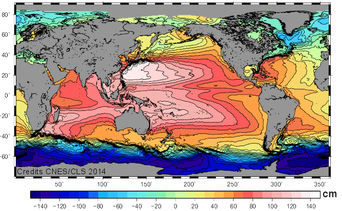
The point of estimating a global Mean Dynamic Topography (MDT) is to reference the altimeter Sea Level Anomalies (SLA), computed relative to a 20 year (1993-2012) mean profile, in order to obtain absolute measurements of the ocean dynamic topography.
Required MDT has to be consistent with altimeter physical content and shall therefore correspond to the mean over 1993-2012 of both the barotropic and baroclinic components of the ocean absolute dynamic topography.
Note that the Ssalto/Duacs (M)SLA products are computed relative to 1993-2012 period since April 2014 (Duacs 2014 v15.0 version). Thus it is mandatory to be consistent and use (M)SLA and MDT referenced to the same time period. Further information on the change of the altimeter reference period.
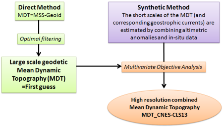
The MDT_CNES-CLS13 calculation combines several steps:
- We first use a direct method to estimate at large scale a MDT using the Mean Sea Surface MSS_CNES-CLS11 and the EGM-DIR-R4 geoid model (this model is based on 2 years of reprocessed GOCE data and 7 years of GRACE data).
- Then we use a synthetic method where sea level anomalies are subtracted from in-situ measurements of the ocean state (dynamic heights over the 1993-2012 period and geostrophic surface velocities over the 1993-2012 period) to compute synthetic estimates of the MDT and the corresponding mean geostrophic surface velocities.
- Then, using a multivariate objective analysis, the synthetic estimates of mean heights and mean velocities are used to improve the first guess of the MDT. It's the calculation of the CMDT (Combined Mean Dynamic Topography).
- Finally, a validation is done by comparing the MDT_CNES-CLS13 with others MDT: CNES-CLS09, Rio05, Maximenko et al. 2009, Glorys1V1 and DNSC.
See also references & publications.
Data
- Products guide.
 Products .
- Sea surface height products .
- Value-added products .
- Wind/wave products .
- Auxiliary products .
- Sentinel-6 Level-2P skewness products.
- MSS .
- MDT .
- Global tide - FES.
- Coastal Tide - XTRACK .
- Internal tide - MIOST.
- Dynamic Atmospheric Correction using ERA5.
- Dynamic Atmospheric Correction dedicated to SWOT CalVal Phase .
- Dynamic Atmospheric Correction .
- Wet troposphere correction from water vapour climate data records.
- GPD+ Wet Tropospheric Correction.
- Slope correction for Sentinel-6A SAR altimetry.
- Range latitudinal empirical correction for Jason-1/2/3 GDR.
- References.
- Ice products .
- Ocean indicators products .
- Ocean data challenges .
- Tide Gauges products.
- Data access .
- Product information .
- CALVAL .