


The Combined Mean Dynamic Topography MDT CNES-CLS18
The point of estimating a global Mean Dynamic Topography (MDT) is to reference the altimeter Sea Level Anomalies (SLA), computed relative to a 20 year (1993-2012) mean profile, in order to obtain the full signal that results from the dynamic of the ocean : the Absolute Dynamic Topography (ADT).
Note that the Ssalto/Duacs (M)SLA products are computed relative to 1993-2012 period since April 2014 (Duacs 2014 v15.0 version and posterior version). Thus it is mandatory to be consistent and use (M)SLA and MDT referenced to the same time period.
The MDT CNES-CLS calculation combines several steps:
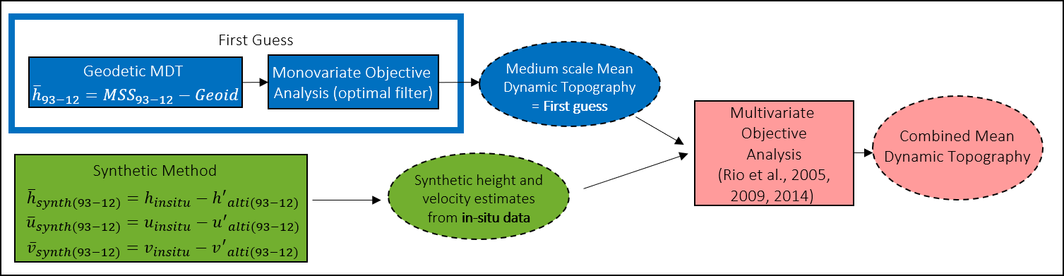
- We first compute a first guess: a medium scale of Mean Dynamic Topography using only satellite data (gravimetry and altimetry). The raw difference of Mean Sea Surface with geoid model is filtered using an optimal filter to remove noise and residual geodetic signal.
- Beside we compute synthetic estimate of MDT and mean geostrophic current from oceanic in-situ data (T/S profiles and drifters).
- First, the data are processed to have the same physical content as altimetry:
- the drifters (SVP and Argo drifting at the surface) are processed to only extract the geostrophic component
- also deep baroclinic and barotropic components are added to dynamic height computed from T/S profiles.
- Then sea level anomalies are interpolated and subtracted from in-situ measurements of the ocean state to estimate a mean: MDT and the corresponding mean geostrophic surface velocities.
- First, the data are processed to have the same physical content as altimetry:
- Then, using a multivariate objective analysis, the synthetic estimates of mean heights and mean velocities are combined to improve the first guess of the MDT.
- Finally, a validation is done by comparing this version to other MDTs and independent in-situ data.
The Table below lists the input data and improvement done for the new CNES-CLS18 compared with the previous CNES-CLS13.
| MDT CNES-CLS18 | MDT CNES-CLS13 | ||
|---|---|---|---|
| First guess | MSS used | CNES-CLS15 (Pujol et al, 2018) | CNES-CLS11 (Schaeffer et al, 2012) |
| Geoïd | GOCO05S (Mayer-Gürr,et al. 2015) Complete GOCE mission (Nov 2009-October 2013) + 10.5 years of GRACE data | EGM-DIR-R4 (Bruinsma et al, 2012) 2 years of reprocessed GOCE data +7 years of GRACE data | |
| First Guess filtering | Optimal filter (Rio et al, 2011) with updated parameters | Optimal filter (Rio et al, 2011) | |
| Synthetic estimate from in-situ data | Hydrological data | CTD and ARGO Pref variable 200/400/900/1200/1900 from CORA4.2 (1993-2013), CORA5.0 (2014-2015) and CORA5.1 (2016) Period 1993-2016 | CTD (Cora3.4), ARGO Pref variable 200/400/900/1200/1900 Period 1993-2012 |
| Drifter Data | SD-DAC drifter, both drogued and undrogued: 1993-2016 Argo floats surface velocities: 1997-2016 | SD-DAC drifter, both drogued and undrogued: 1993-2012 Argo floats surface velocities: 1997-2013 | |
| Ekman model | Parameters fitted over the period 1993-2016 by latitude and Mixed Layer Depth (from ARMOR3D) Two levels: 0m and 15m | Parameters fitted over the period 1993-2012, by longitude, latitude and month (Rio et al, 2014) Two levels: 0m and 15m | |
| Wind Slippage correction | Update of Rio et al, 2012 in order not to discard the trajectories beginning/end | Rio et al, 2012 | |
| Drifter filtering | Max (24 hours, Inertial Period) | 3 days | |
| Altimeter data | Delayed-Time CMEMS-DUACS 2018 (Taburet et al, under review) | Delayed-Time DUACS-2010 (Dibarboure et al, 2011) | |
| Inversion | Resolution | Global 1/8° | Global 1/4° |
Data
- Products guide.
 Products .
- Sea surface height products .
- Value-added products .
- Wind/wave products .
- Auxiliary products .
- Sentinel-6 Level-2P skewness products.
- MSS .
- MDT .
- Global tide - FES.
- Coastal Tide - XTRACK .
- Internal tide - MIOST.
- Dynamic Atmospheric Correction using ERA5.
- Dynamic Atmospheric Correction dedicated to SWOT CalVal Phase .
- Dynamic Atmospheric Correction .
- Wet troposphere correction from water vapour climate data records.
- GPD+ Wet Tropospheric Correction.
- Slope correction for Sentinel-6A SAR altimetry.
- Range latitudinal empirical correction for Jason-1/2/3 GDR.
- References.
- Ice products .
- Ocean indicators products .
- Ocean data challenges .
- Tide Gauges products.
- Data access .
- Product information .
- CALVAL .