


Regional heat content change over the Atlantic Ocean with the space geodetic approach
Given the major role of the Ocean in the climate system, it is essential to characterize the temporal and spatial variations of its heat content. The 4DATLANTIC-OHC project (2021-2025) aims at developing and testing space geodetic methods - from satellite altimetry and gravimetry - to estimate the regional ocean heat content (OHC) change.
The space geodetic approach
The OHC change can be estimated directly from net ocean surface heat fluxes measured based on CERES space measurements, from in situ data observed by the ARGO floats or from ocean model reanalyses. Here we estimate the OHC change from an alternative method based on satellite altimetry and gravimetry observations and in-situ observations which complement these other approaches and which is very promising to reduce uncertainty estimates.
The OHC change is estimated from the measurement of the thermal expansion of the ocean based on differences between the total sea-level content derived from altimetry measurements and the mass content derived from gravimetry data. This space geodetic approach provides consistent spatial and temporal sampling of the ocean. It samples nearly the entire global ocean, except in polar regions where the sea is partially or completely covered with sea ice (i.e. essentially north of 80°N) and it provides estimates of the OHC variations over the ocean’s full depth.
Application to the Atlantic Ocean and objectives
The ESA-funded project MOHeaCAN acted as a proof-of-concept, describing the application of the space geodetic approach on a global scale (Marti et al., 2022). The objective of the 4DAtlantic-OHC project provides the opportunity to extend MOHeaCAN’s work at regional scale where new challenges need to be taken up. Indeed, a series of processes and parameters (coastal area, mixed layer variability,...) that could be neglected at global scale cannot be neglected anymore at regional scale.
The strategy established at global scale has been extended and further developed at regional scale both for the data generation and the uncertainty estimate.
Versions 1 and 2 of the product were only available on the Atlantic Ocean, while version 3 is now available on the global ocean.
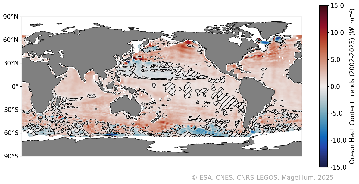
The “altimetry-gravimetry” method allows retrieving the OHC change (also called the ocean heat uptake) from April 2002 onwards (corresponding to first GRACE gravimetry data). Map of the regional OHC trends over April 2002 to September 2023 are displayed here (product version 3.0). Hatched areas are regions where regional OHC trends are not significant at the 68% confidence level (CL).
Therefore we need to explore the capability of EO missions and EO-based products in terms of space and time resolution to monitor the regional OHC in the Atlantic Ocean. In addition, we need to develop a proper scheme to characterise and then propagate the uncertainty of the input measurements to derive reliable uncertainties of the final estimate of the regional OHC.
The 4DAtlantic-OHC project’s objectives are:
- to develop, test and validate a regional EO-based Atlantic OHC product to enable a realistic monitoring of the Global Ocean Heat Uptake and to understand the role played by the Ocean in the climate system.
- to use and analyse the product to better understand the complexity of the Earth and climate system. The investigation will be focused on the Meridional Heat Transport (MHT) in the North Atlantic with a regional heat budget.
- to promote and use the product to assess its strengths and limitations for the implementation of new solutions for society.
The 4DAtlantic-OHC product
Users will be mainly interested in:
- Monthly gridded heat content change
- OHC trends and their uncertainties
Product Versions
Consult the table below for the different versions of the 4DAtlantic-OHC product.
DOI and metadata
This product is referenced with a DOI: 10.24400/527896/a01-2022.012
More metadata: https://commons.datacite.org/doi.org/10.24400/527896/a01-2022.012
Product access and condition of access
The product (NetCDF file) can be downloaded in open acces on the HTTPS server
The product is available free of charge for any project or study, and delivered as stated in the licence agreement.
Citation
If you use the data, please cite:
"The 4DAtlantic OHC product from space altimetry and space gravimetry was produced by Magellium/LEGOS and distributed by AVISO+ (https://aviso.altimetry.fr) with support from ESA (https://doi.org/10.24400/527896/a01-2022.012 version XX)"
Contacts
For any technical issues or additional information related to the 4D Atlantic OHC product, users are advised to contact AVISO: aviso(at)altimetry.fr
Acknowledgment
This work is supported by the European Space Agency in the framework of the 4DAtlantic-Ocean heat content Project (ESA Contract number 4000134928/21/I-NB): https://eo4society.esa.int/projects/4datlantic-ohc/
References
Ablain et al., OSTST 2022: Monitoring the regional heat content change over the Atlantic Ocean with the space geodetic approach: the 4DATLANTIC-OHC project
Blazquez, A., Meyssignac, B., Lemoine, J., Berthier, E., Ribes, A. and Cazenave, A. (2018) Exploring the uncertainty in GRACE estimates of the mass redistributions at the Earth surface: implications for the global water and sea level budgets, Geophys. J. Int., 215(1), 415–430, doi:10.1093/gji/ggy293, 2018.
Marti, F., Blazquez, A., Meyssignac, B., Ablain, M., Barnoud, A., Fraudeau, R., Jugier, R., Chenal, J., Larnicol, G., Pfeffer, J., Restano, M., and Benveniste, J.: Monitoring the ocean heat content change and the Earth energy imbalance from space altimetry and space gravimetry, Earth Syst. Sci. Data Discuss., 1–32, doi: 10.5194/essd-2021-220, 2021.
Meyssignac, B., Fourest, S., Mayer, M. et al. North Atlantic Heat Transport Convergence Derived from a Regional Energy Budget Using Different Ocean Heat Content Estimates. Surv Geophys 45, 1855–1874 (2024). https://doi.org/10.1007/s10712-024-09865-5
Rousseau, V., Fraudeau, R., Hammond, M., Houndegnonto, O. J., Ablain, M., Blazquez, A., Calafat, F. M., Desbruyères, D., Foti, G., Llovel, W., Marti, F., Meyssignac, B., Restano, M., and Benveniste, J.: Monitoring the regional Ocean Heat Content change over the Atlantic Ocean with the space geodetic approach, Earth Syst. Sci. Data Discuss. [preprint], https://doi.org/10.5194/essd-2023-236 , 2023.
List of the product versions
Name | Version | Publication date | Product characteristics | Documentation | Product access | |||
| Product user manual | Algorithm theoretical basis document | Associated publication | HTTPS | FTP | ||||
| 4DAtlantic-OHC | 1.0 | Oct 2022 | Atlantic ocean 1*1 deg 04/2002-12/2020 Monthly | Experimental Dataset Description (EDD v1.1) | ATBD v1.2 | - | open access | non authenticated ftp |
| 2.0 | May 2025 | Atlantic ocean 1*1 deg 04/2002-12/2022 Monthly | Experimental Dataset Description (EDD v2.0) | ATBD v2.0 | - | |||
| 3.0 | November 2025 | Global Ocean 1*1 deg 04/2002 - 09/2023 Monthly | Experimental Dataset Description (EDD v3.0) Product Validation Report (PVR v3.0) | ATBD v3.0 | - | |||
Data
- Products guide.
 Products .
- Sea surface height products .
- Value-added products .
- Wind/wave products .
- Auxiliary products .
- Ice products .
- Ocean indicators products .
- El Niño Southern Oscillation - ENSO.
- Mean Sea Level .
- Kuroshio.
- Analysis of climate feedback PArameter Changes from Heat Evolution (APACHE).
- Ocean Heat Content and Earth Energy Imbalance .
- Global Ocean Heat Content change and Earth Energy Imbalance.
- Atlantic Ocean heat content change.
- Barystatic and manometric sea level changes from satellite geodesy.
- Ionian Sea circulation.
- Ocean data challenges .
- Tide Gauges products.
- Data access .
- Product information .
- CALVAL .