


Aviso global sea surface height products
Aviso has been distributing Topex/Poseidon and ERS altimetric data worldwide since 1992. Since launches of new altimetric mission, series of products has been completing the Aviso catalogue. Following table presents applications, features and time availability of all available products obtained by satellite or combining available data of all satellites.
The Copernicus Marine and Environment Monitoring Service (CMEMS) is in charge of the processing and distribution of Ssalto/Duacs gridded "allsat" series and along-track Sea Level Anomalies, Absolute Dynamic Topographies and Geostrophic velocities over the Global Ocean, Mediterranean Sea, Black Sea, European Seas and Acrtic Ocean areas, in Delayed-Time and in Near-Real-Time .
The Copernicus Climate Change Service (C3S) is in charge of the processing and distribution of Ssalto/Duacs gridded Delayed-time "twosat" series of Sea Level Anomalies, Absolute Dynamic Topographies and Geostrophic velocities over the Global Ocean, Mediterranean Sea, Black Sea.
All those products were formerly distributed by Aviso+ with no changes in the scientific content.
Note that the Mozambique area and the Climatologies are still disseminated by Aviso+.
Swot products
| Swot products | |
|---|---|
SWOT L3 Ocean productsContents: The SWOT_L3_SSH product provides ocean topography measurements obtained from the SWOT KaRIn and nadir altimeter instruments | |
SWOT KaRIn Low Rate Ocean productsContents: The L2_LR_SSH product provides measurements over ocean surfaces from the low rate (LR) data stream of the SWOT KaRIn instrument. | |
Swot simulated productsContents: Simulated SWOT Sea Surface Height products KaRIn and Nadir. | http://doi.org/10.24400/527896/a01-2021.006 |
Gridded products
| Gridded products | 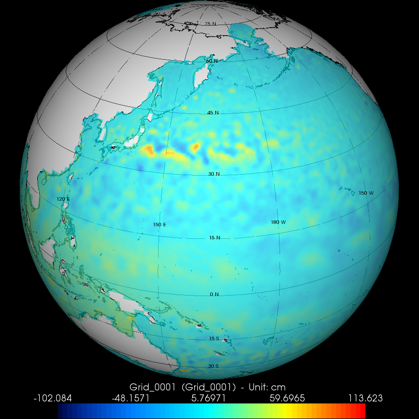 |
|---|---|
Gridded SSALTO/DUACS experimental products including CFOSat for wave-current intercations studiesgridded merged products of SLA and geostrophic velocities | SSALTO/DUACS experimental products including CFOSat for wave-current intercations studies |
Ssalto/Duacs experimental products: velocities combining altimetry and SSTContents: Gridded optimally merged velocities combining altimetry and SST. It is part of a group of experimental products. Available in delayed time for the year 2015. | -SSALTO/Duacs experimental |
Ssalto/Duacs experimental products: Sea Level heights computed with Multiscale InterpolationContents: Gridded sea level heights and derived variables computed with Multiscale Interpolation. It is part of a group of experimental products. Available in delayed time for the year 2017. | -SSALTO/Duacs experimental |
Ssalto/Duacs experimental products: Sea Level heights computed with Multiscale Interpolation combining altimetry and driftersContents: Gridded sea level heights and derived variables computed with Multiscale Interpolation combining altimetry and drifters. It is part of a group of experimental products. Available in delayed time for the years 2016 to 2020. | -SSALTO/Duacs experimental |
Ssalto/Duacs Sea Level Anomaly, Absolute Dynamic Topography, geostrophic currents (anomalies and absolute) (1/4°x1/4° on a Cartesian grid)Condition of access : | -Gridded Sea Level heights and derived variables
|
Ssalto/Duacs Monthly mean and Climatology Gridded Sea level anomalies (1/4°x1/4° on a Cartesian grid)Contents: Monthly and seasonal gridded sea surface heights computed with respect to a twenty-year mean (averaged sea surface heights averaging month by month and climatological sea surface heights calculated by averaging sea level anomalies over a same month). | |
Mean Sea Level Cnes/Legos/CLS (2°x 2° on a Mercator grid)Contents: Map of regional patterns of observed sea level (mm/year), time serie of the reference mean sea level since January 1993. Use: study of the climate change. | - MSL |
Along-track products
| Along-track products | 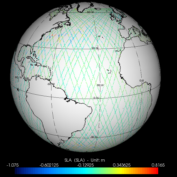 |
|---|---|
ALTimetry Innovative Coastal Approach Product (ALTICAP)Content: Jason-3 along-track delayed time corrected Sea level anomalies with corrections and auxiliary parameters | 10.24400/527896/a01-2023.020 |
Along-track SSALTO/DUACS experimental products including CFOSat for wave-current intercations studiesalong-track CFOSat products geostrophic velocities | SSALTO/DUACS experimental products including CFOSat for wave-current intercations studies |
Ssalto/Duacs Sea level anomaly and Absolute dynamic TopographyCondition of access: The Copernicus Marine and Environment Monitoring Service (CMEMS) is in charge of the processing and distribution of those products (formerly distributed by Aviso+ with no changes in the scientific content). | - Along-track sea level heights |
OSTM/Jason-2 Sea Surface Height AnomaliesContents: OSTM/Jason-2 along-track sea surface heights computed with respect to CLS01 mean sea surface. Available in real-time, near-real time and delayed-time. | - GDR-SSHA |
OSTM/Jason-2 Experimental coastal and hydrology productsContents: OSTM/Jason-2 20 Hz along-track measurements, corrections to apply, in near-real time with specific processing. | - Coastal |
Sentinel3 Experimental products (peachi)Contents: Mono-mission Sentinel-3A altimetry product, LR-RMC mode | S3 experimental products |
Monomission Corrected Sea Surface HeightsContents: along-track corrected sea surface heights wrt reference ellipsoid, with corrections, significant wave heights and backscatter coefficient. | - DT-CorSSH and L2P |
Geophysical DataContents: along-track altimetric measurements averaged over 1 seconde, corrections to apply | - IGDR - GDR |
Geophysical and sensor dataContents: 20 Hz along-track waveform information, corrections to apply | - SGDR (TP, Jason-1/2/3, Saral) |
Data
- Products guide.
 Products .
- Sea surface height products .
- Global.
- SWOT L3 Ocean products.
- SWOT KaRIn Low Rate Ocean products.
- ALTimetry Innovative Coastal Approach Product (ALTICAP) .
- Simulated SWOT products.
- SSALTO/DUACS Experimental products.
- Experimental Multimission Gridded L4 sea level heights and velocities with SWOT (MIOST).
- Experimental Multimission Gridded L4 sea level heights and velocities with SWOT.
- SSALTO/DUACS Experimental products including CFOSat for wave-current interactions studies.
- Gridded sea level heights and derived variables - Multiscale Interpolation.
- Gridded sea level heights and derived variables - Multiscale Interpolation combining altimetry and drifters.
- Gridded velocities - altimetry and SST.
- Gridded Mean and Climatology.
- SSHA.
- Along-track Sea Level Anomalies (L2P).
- GDR, IGDR and OGDR.
- Experimental Sentinel-6 products.
- Experimental Sentinel 3 products (Peachi).
- Waveforms.
- Along-track Sea Level Heights.
- Gridded Sea Level Heights and derived variables.
- Coastal and Hydrological products.
- Regional .
- Global.
- Value-added products .
- Wind/wave products .
- Auxiliary products .
- Ice products .
- Ocean indicators products .
- Ocean data challenges .
- Tide Gauges products.
- Data access .
- Product information .
- CALVAL .