


Experimental multimission gridded L4 sea level heights and velocities with SWOT (MIOST)
Type of dataset: SSALTO/DUACS Mutlimission Experimental Level-4 maps, computed with SWOT Level-3 products (using both KaRIn and nadir instruments).
Digital Object Identifiers (DOIs): For V3.0 and v2.0.1: 10.24400/527896/a01-2025.001 - more metadata
Condition of access: Users should keep in mind that these products are experimental products. Notably, they are not produced on an operational basis. These products are available free of charge for any purpose (scientific, operational, commercial, etc.) as stated in the licence agreement.
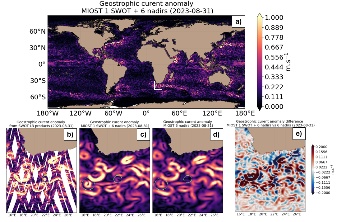
Contents: multimission sea surface heights and derived geostrophic velocity computed from nadirs and SWOT altimetry data, and in using the Multiscale Interpolation Ocean Science Topography (MIOST, Ubelmann et al., 2021)
Use: regional studies, ocean variability (mesoscale circulation,...).
Description: These gridded products are produced from the upstream following data:
- for satellites SARAL/AltiKa, Cryosat-2, HaiYang-2B, Jason-3, Copernicus Sentinel-3A&B, Sentinel 6A, SWOT Nadir
- NRT (Near-Real-Time) Nadir along-track (or Level-3) SEA LEVEL products (DOI: https://doi.org/10.48670/moi-00147 ) delivered by the Copernicus Marine Service (CMEMS, http://marine.copernicus.eu/ ). The gridded product is based on NRT L3 Nadir datasets for the period from July 7, 2025, to December 31, 2025.
- MY (Multi-Year) Nadir along-track (or Level-3) SEA LEVEL products (DOI: https://doi.org/10.48670/moi-00146 ) delivered by the Copernicus Marine Service (CMEMS, http://marine.copernicus.eu/ ). The gridded product is based on MY L3 Nadir datasets for the period from March 28, 2023, to July 6, 2025.
- for SWOT KaRIn : the SEA LEVEL products L3_LR_SSH (V3.0) delivered by AVISO for Expert SWOT L3 SSH KaRin (DOI: https://doi.org/10.24400/527896/A01-2023.018) for the period from March 28, 2023 to December 31, 2025.
One mapping algorithm is proposed: the MIOST approach which give the global SSH solutions: the MIOST method is able of accounting for various modes of variability of the ocean surface topography (e.g., geostrophic, barotrope, equatorial waves dynamic …) by constructing several independent components within an assumed covariance model.
Geographic coverage: global (80°S-0°W/90°N-360°E)
Citation: When using the SSALTO/DUACS experimental products, please cite: "These products were processed by SSALTO/DUACS and distributed by AVISO (https://www.aviso.altimetry.fr) supported by CNES (version 3.0). DOI: 10.24400/527896/a01-2005.001”
Resources:
- User handbook: SSALTO/DUACS experimental products handbook: Gridded Sea Level Height and geostrophic velocities computed with SWOT Level-3 products (using both KaRIn and nadir instruments) with MIOST.
- Release note for version 2.0.1
- Ballarotta, M., Ubelmann, C., Bellemin-Laponnaz, V., Le Guillou, F., Meda, G., Anadon, C., Laloue, A., Delepoulle, A., Faugère, Y., Pujol, M.-I., Fablet, R., and Dibarboure, G.: Integrating wide swath altimetry data into Level-4 multi-mission maps, EGUsphere [preprint], doi.org/10.5194/egusphere-2024-2345, 2024.
- Ubelmann, C., Dibarboure, G., Gaultier, L., Ponte, A., Ardhuin, F., Ballarotta, M., & Faugère, Y.: Reconstructing ocean surface current combining altimetry and future spaceborne Doppler data. Journal of Geophysical Research: Oceans, 126, e2020JC016560. https://doi.org/10.1029/2020JC016560, 2021
Delayed-time gridded Experimental product with SWOT
| Satellite | Version | Mapping Method | Area | Type | Authenticated access service | Data period | File weight | Handbook |
|---|---|---|---|---|---|---|---|---|
| Merged | v3.0 | MIOST | global | gridded | CNES AVISO FTP/SFTP access (with AVISO+ credentials):
CNES AVISO THREDDS Data Server access: | 2023/03/28-2023/07/10 (calval) 2023/07/11-2025/12/31 (science) | 42 MB per file | product user manual (v3.0) |
| v2.0.1 | 2023/03/28-2023/07/10 (calval) 2023/07/11-2025/06/30 (science) | 42 MB per file | product user manual (v2.1) |
Data
- Products guide.
 Products .
- Sea surface height products .
- Global .
- SWOT L3 Ocean products.
- SWOT KaRIn Low Rate Ocean products.
- ALTimetry Innovative Coastal Approach Product (ALTICAP) .
- Simulated SWOT products.
- SSALTO/DUACS Experimental products.
- Experimental Multimission Gridded L4 sea level heights and velocities with SWOT (MIOST).
- Experimental Multimission Gridded L4 sea level heights and velocities with SWOT.
- SSALTO/DUACS Experimental products including CFOSat for wave-current interactions studies.
- Gridded sea level heights and derived variables - Multiscale Interpolation.
- Gridded sea level heights and derived variables - Multiscale Interpolation combining altimetry and drifters.
- Gridded velocities - altimetry and SST.
- Gridded Mean and Climatology.
- SSHA.
- Along-track Sea Level Anomalies (L2P).
- GDR, IGDR and OGDR.
- Experimental Sentinel-6 products.
- Experimental Sentinel 3 products (Peachi).
- Waveforms.
- Along-track Sea Level Heights.
- Gridded Sea Level Heights and derived variables.
- Coastal and Hydrological products.
- Regional .
- Value-added products .
- Wind/wave products .
- Auxiliary products .
- Ice products .
- Ocean indicators products .
- Ocean data challenges .
- Tide Gauges products.
- Data access .
- Product information .
- CALVAL .