


Siral altimeter
Cryosat-2's primary payload will be the SAR/Interferometric Radar Altimeter (Siral), which has extended capabilities to meet the measurement requirements for ice-sheet elevation and sea-ice freeboard.
Derived from Poseidon altimeters, Siral included important evolutions to operate on rough surfaces :
- Low-resolution mode like a conventional altimeter, on land ice or sea which are composed of few rough surfaces,
- SAR mode operating a high resolution measurement on sea ice,
- SAR interferometer (SARIn) mode operating on rough surfaces like on the sea ice/land limit.
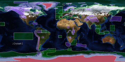
Surfaces operated by the 3 modes of Siral (updated in July 2013).
SAR (green) is operated over sea-ice areas and over some ocean basins and coastal zones.
SARIn (purple) mode is used over ice-sheet margins, over some geostrophic ocean currents and over small ice caps and areas of mountain glaciers. It is also used over some major hydrological river basins.
LRM is operated over areas of the continental ice sheets (red), over oceans and over land not covered by other modes. See the Esa's webpage to download the kml file. Credits ESA.
Function
Siral measures range (the distance from the satellite to the Earth's surface).
Principle
Siral is a Ku-band instrument (13.575 GHz).
Conventional radar altimeters send pulses with a long interval : about 500 microseconds. The Cryosat altimeter sends a burst of pulses with an interval of only 50 microseconds between them. The returning echoes are thus correlated, and by treating the whole burst of pulses in one operation, the data processor can separate the echo into strips arranged across the track by exploiting the slight frequency shifts (caused by the Doppler effect) in the forward- and aft-looking parts of the beam. The strips laid down by successive bursts can therefore be superimposed on each other and averaged to reduce noise. This mode of operation is called Synthetic Aperture Radar, or SAR mode.
In interferometric mode (SARIN), a second receiving antenna is activated to measure the arrival angle. It enables to receive some radar echos coming from a point not directly located beneath the satellite. The difference in the path-length time of the radar echos is tiny between radar echos on the track and radar echoes out of the track. The measure of the angle between the baseline joining the antennas and the echo direction is essential and must be very accurate. The baseline orientation is so operated by three star trackers.
Further information : Cryosat mission overview (Esa website)