


Doris (Doppler Orbitography and Radiopositioning Integrated by Satellite)
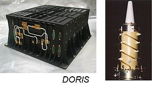
The Doris instrument onboard Swot provides real-time location and precise orbit determination. Doris measurements are also used for geophysical studies, in particular through the International Doris Service (IDS). Doris is a dual-frequency instrument able to determine atmospheric electron content.
Doppler Orbitography and Radiopositioning Integrated by Satellite (Doris) is a satellite tracking system designed in the late 1980s by Cnes as a new system to provide precise orbits on-board low Earth orbit satellites. The operation of Doris relies on a dense global network of ground stations transmitting omnidirectional signals at a known frequency.
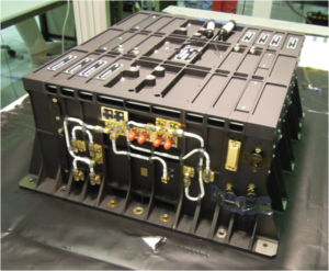
Swot is equipped with the same new-generation (multi-channel and digital) receiver than Sentinel-3, developed by Cnes, as a Customer Furnished Instrument (CFI). This type of receiver is also flying on Jason-2, Jason-3, Saral, HY-2A and Cryosat-2 and is able to track up to seven beacons simultaneously. It was shown that real-time accuracy of the Doris navigation solution (Diode) is about 3.5 cm. Diode is used to drive the open loop tracking mechanism of the nadir altimeter. The offline POD performance is approximately 1 cm on the radial direction (nadir), as for the Jason & Sentinel-3 satellites.
The combination of both GPS and Doris measurements in POD processing improves the final performance on the three directions.
Function
Real-time location: Diode
The Diode onboard navigator locates the satellite on orbit in real time. This information is essential for providing altimetry data in real time or near-real time.
Doris Diode real-time location is coupled with Poseidon-3B altimeter, thus enabling better altimeter data acquisition in areas like coastal zones, inland waters and ice.
Precise orbit determination
Doris measurements are used for precise orbit determination (POD).
Ionospheric electron content
By measuring and comparing the path delay of signals transmitted at two separate frequencies, Doris is able to calculate the electron content in the atmosphere.
This function complements the Poseidon-3 dual-frequency altimeter function.
Principle
Doris orbitography beacons transmit signals at two separate frequencies (2036.25 MHz and 401.25 MHz) to the satellite. The receiver onboard the satellite analyzes the received signal frequencies to calculate its velocity relative to Earth. This velocity is fed into orbit determination models to derive the satellite's position on orbit below 1 centimeter on the radial component.
Further information :
- Doris on Aviso website.
- International Doris Service (IDS).
Missions
- Timeline Altimetry.
 Past missions .
- Current missions .
- Cryosat .
- Saral .
- Jason-3 .
- Sentinel-3A .
- Sentinel-3B.
- CFOSAT .
- HY-2B.
- HY-2C.
- HY-2D.
- Sentinel-6MF .
- Swot .
- SWOT Links and References.
- Objectives & Applications .
- Program.
- SWOT Ocean Data Access.
- Instruments .
- Data products.
- Error budget.
- Orbit .
- Portfolio of Swot first results .
- Changing scale in eddy observation.
- Visualisation.
- Utilizing CNES HPC infrastructure for Swot project hosting.
- Mission performances (Nadir).
- Sentinel-6B.
- Future missions .