


Objectives and applications
Cnes, Nasa, the Canadian Space Agency and the UK Space Agency are collaborating on the Swot mission, which was launched in December 2022. Swot is the first satellite to address both ocean and hydrology objectives. Thanks to its new technical concept, a wide-swath interferometric altimeter, the Swot mission constitutes a major design break in space altimetry. It brings innovation in technology, science and application areas.
Water is a basic need for life
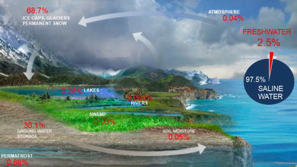
About 71 percent of the Earth's surface is water-covered and the saline waters hold about 97.5 % of all Earth's water (oceans, saline groundwaters and saline lakes). Freshwater is present in very limited quantities on our planet: 2.5% of all Earth’s water. The majority of freshwater is locked up in glaciers, ice caps or underground. The tiny remaining portion found on the surface (lakes, rivers) is directly available for our basic needs.
Dedicated to measure global surface water in lakes and rivers and to acquire highly precise data on ocean topography, the Swot mission contributes to understand and characterize the water cycle and to address the challenge of climate change by helping sustainable management of water resources.
Scientific objectives
The Swot mission aims to measure water heights (and their space-time variations) of rivers, lakes and flooded zones as well as the ocean mesoscale and submesoscale circulation. The interferometric altimetry enables to give a bi-dimensional image with a horizontal resolution of about 5 m (along-track) x 10-70 m over land, and 250 m x 250 m over ocean.
In oceanography
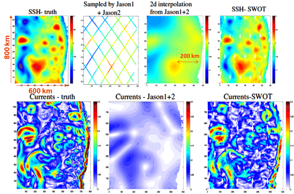
Over the ocean, nadir altimetry is a mature technique after more than 30 years of continuous measurements. This conventional altimetry technique has provided precise 2D-mapped ocean observations at scales of more than 200 km. The key instrument payload of Swot is the Ka-band Radar Interferometer instrument (KaRIn, see Instruments and Interferometer Technique). Due to the interferometry technique, KaRIn makes simultaneously high-resolution and large coverage images.
The primary oceanographic objective of the Swot mission is therefore to characterize meso- and sub-mesoscale 2D ocean circulations with a spatial resolution of 15 km. These mesoscale and submesoscale processes include the formation, evolution and dissipation of eddy variability associated with including narrow currents, fronts, filaments and quasi-geostrophic turbulence. Most of the kinetic energy of the ocean occurs at these scales, and these processes play a key role in the horizontal and vertical transport of heat, carbon and nutrients. They affect climate via the modulation of sea surface temperature and heat flux, as well as the oceanic uptake of carbon from the atmosphere which has a major role in the energy transport in oceans. Further information in White Paper (March 2015, P.Klein, pdf) and in Applications > Submesoscale circulation.
By providing high-resolution 2D observations in coastal regions, Swot is able to observe finer-scale coastal currents and storm surges; its swath coverage allows to characterize the spatial structure and the dynamic of the coastal processes. Further information in Coastal and Estuaries White Papers (March 2015, B.Laignel and N.Ayoub) and in Applications > Submesoscale circulation.
The Swot orbit has been chosen to correctly separate the tidal constituents, and the fine-scale observations right up to the coast and in high latitudes is improving the knowledge of coastal tides as well as internal tides that have not been well sampled by conventional altimetry. Further information in White Paper (January 2015, K.Brian, pdf) and in Applications > Internal tides.
Swot data are useful for a wide range of potential applications: integrated management of estuaries, more accurate weather and climate forecasting, help with navigation and sea rescue operations, helping fishermen, assisting oil platforms operations…
In hydrology
Although initially developed for studying ocean surfaces, nadir altimetry rapidly broadened its scope to include monitoring of major inland waters such as the American Great Lakes and other inland seas. Gradually, the increasing mastery of the altimetry technique, with specific processing and correction has enabled smaller features to be monitored and measurement quality to be improved. Another constraint is due to the conventional altimetry technique itself. The altimeter provides measurements exactly at the satellite's nadir, i.e. for a limited area along the satellite's ground track, which restricts spatial sampling and rules out any global, systematic monitoring of inland waters.
Nadir altimeters are missing more than 60% of lakes thus only measuring a small fraction of the global lake storage change.
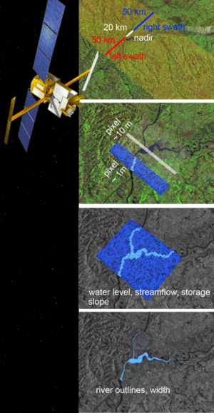
Thanks to interferometry technique, Swot provides high-resolution observations (also) over land. Swot is designed to observe nearly all surface water bodies as small lakes or reservoirs (surface from 250 m x 250 m with a goal of 100 m x 100 m), rivers (width larger than 100m with a goal of 50 m) but also floodplains, channels, wetlands and uplands that should be identified and measured accurately. Swot thus measures 65% of the global lake storage change.
(Top): Artist view of Swot and schematic view of its measurements over rivers.
(Bottom): video excerpt illustrating these measurements. See the entire video by downloading the video file here. Credits Cnes, Mira Productions, 2015.
The primary hydrologic objectives of the Swot mission are to characterize the spatial and temporal variations in surface waters, globally. Swot is able to measure the global storage change in terrestrial surface water bodies and to estimate the global change in river discharge.
These hydrological observations are extremely important to perfect our knowledge of the global dynamics of continental waters and their interaction with the coastal part of the oceans at the estuaries. This new capability enables the monitoring of the evolution of fresh water supply in the climate change context, notably in the regions where few observations exist.
Swot measurements are of value to a host of hydrological applications: management of water sharing issues (international, interregional), improved flood modeling, management of fresh water for urban, industrial and agricultural consumption, management of hydropower, prevention of the spreading of epidemics, help to river navigation.
Further information:
- Links and references on Swot
- Swot, Gallery: presentation leaflet, kakemono
- Report of the first Swot User Workshop: in the frame of the Swot Application Working Group (SAWG), a first user workshop was held in San Diego, 12 January 2015. Please read the final report (pdf, 1.1MB).
Missions
- Timeline Altimetry.
 Past missions .
- Current missions .
- Cryosat .
- Saral .
- Jason-3 .
- Sentinel-3A .
- Sentinel-3B.
- CFOSAT .
- HY-2B.
- HY-2C.
- HY-2D.
- Sentinel-6MF .
- Swot .
- SWOT Links and References.
- Objectives & Applications.
- Program.
- SWOT Ocean Data Access.
- Instruments .
- Data products.
- Error budget.
- Orbit .
- Portfolio of Swot first results .
- Changing scale in eddy observation.
- Visualisation.
- Utilizing CNES HPC infrastructure for Swot project hosting.
- Mission performances (Nadir).
- Sentinel-6B.
- Future missions .