


Jason-2, Three years in orbit
With now 3 years in orbit, Jason-2 is fulfilling all mission expectations and provides state of the art quality data to more than 2000 teams around the world.
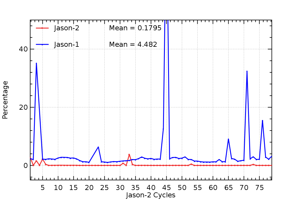
Since the beginning of the mission data availability is very high thanks to a very reliable system and associated ground procedures. In average, only 0.18% of data are missing since launch - and this very low number is mainly related to planned operations (altimeter software upload, routine calibrations, ...). Those events are reported in Jason-2 yearly Calval report (pdf).
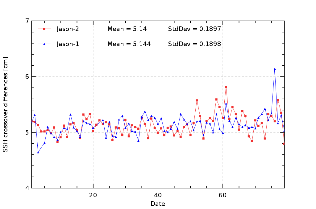
End of 2008, Jason-2 OGDRs and IGDRs data were already available to end users in version "C", the same version as Jason-1 data (for better compatibility). GDR data were released in version T during August 2009. All products quality are routinely verified and the major metrics can be found in the Jason-2 yearly Calval report document. As an example, the cycle by cycle standard deviation of SSH crossovers differences are plotted for Jason-2 and Jason-1 in figure below. Both missions show very good performances, very similar and stable in time. The average figure is 5.14 cm rms for both missions.
Major science results
Among the major science results obtained thanks to Jason-2 data, we may quote :
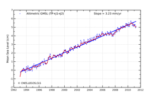
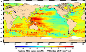
- the continuous mean sea level trend monitoring. The global mean level of the oceans is one of the most important indicators of climate change. It incorporates the reactions from several different components of the climate system. Precise monitoring of changes in the mean level of the oceans, particularly through the use of altimetry satellites, is vitally important, for understanding not just the climate but also the socioeconomic consequences of any rise in sea level.
See pages on Indicator MSL for further details
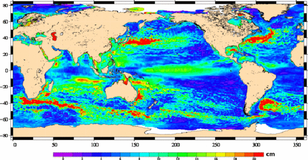
- The analysis of the ocean mesoscale features, thanks to the combination of Jason-2, Jason-1 and Envisat data inside the SALP/Duacs system which reveals the number and strength of eddies which play a major role in the ocean/atmosphere exchanges .
See 177 000 eddies in the ocean (Image of the month, March 2011).
Program background
Jason-2 is the continuation of the existing successful cooperation between the United States and Europe. Cnes and the US National Oceanic and Atmospheric Administration (Noaa) are responsible for satellite operations, while the Jet Propulsion Laboratory (JPL) manages the mission for Nasa. Data processing is carried out by Cnes, Eumetsat and Noaa, depending on the type of product.
A more detailed breakdown of this cooperation is found below:
CNES:
- is responsible for the overall management of the project and the system,
- has provided the satellite system that uses the PROTEUS platformS,
- has contributed to the payload by supplying the POSEIDON3 nadir altimeter, the DORIS onboard system, the technological "passengers" T2L2, Carmen2 and LTP,
- has provided the satellite control centre and a ground station installed in Germany for EUMETSAT,
- operates the satellite during the critical phases, provides the production of steering controls and orbit control and satellite expertise throughout the satellite's entire service life,
- processes, archives and distributes off-line products (I/GDRs), archives operational data (OGDRs).
- acts as an interface with science users,
EUMETSAT:
- supplied the infrastructure for the ground station and provides its maintenance operations,
- processes and distributes operational data (OGDRs),
- acts as an interface between operational users.
NASA:
- supports CNES in the overall management of the system,
- has supplied the vehicle launcher, launch operations and associated infrastructures,
- has contributed to the payload by supplying the UHF radiometer (designed for tropospheric corrections), the GPS receiver and the laser retroreflector (for precise orbit determination).
- Contributes to the validation and expert analysis of the off-line products (I/GDRs)
NOAA:
- has supplied two ground stations,
- has supplied an operations centre and conducts routine operations on the satellite,
- processes and distributes operational data,
- acts as an interface with operational users,
- archives and distributes scientific data.
Further information:
- Jason-2, Three years in orbit! (pdf)
- Missions: Jason-2
- Data on the Aviso website: Jason-2
- Data on the Aviso Cnes Data Center
- News of the Jason-2 mission
- News on the Nasa/JPL website: An altimetry milestone 3rd anniversary OSTM/Jason-2 completes prime mission
- News on the Eumetsat website: Jason-2 celebrates its third anniversary