


Adding an in-depth view to altimetry
Image of the month - September 2002
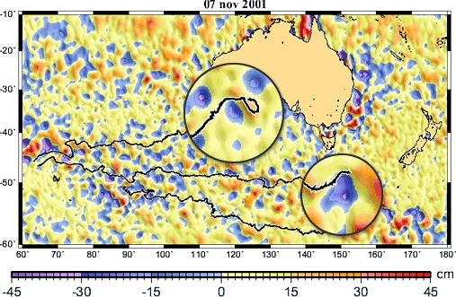
Drifting buoys tracked by Argos (black lines) over sea level anomalies from altimetric satellites Topex/Poseidon and ERS-2 (Ssalto/Duacs data). The animation (5 Mo) shows that buoys drift with the ocean currents, which circulate in a counter-clockwise direction around the hills and in a clockwise (anticyclonic) direction around the valleys (in the Southern Hemisphere). Their general direction is dictated by the Antartic Circumpolar Current.
(Credits Météo France/CLS).
The one major drawback of observing the oceans from space is that electromagnetic waves emitted and received by the satellite do not penetrate far beneath the sea surface. Altimetry satellites able us to estimate many phenomena over the whole water column, however, it can't replace in-situ measurements. Such sensors allow us to generate a three-dimensional picture of the ocean. But in-situ sensors provide point measurements, at a particular moment in time and space, and need people to be released, sometimes refitted,... Satellite-based systems such as Argos, however, make it possible to automatically retrieve data in near-real time. Satellites covers the whole Earth (or most of it), continuously.
In-situ measurements also validate and calibrate satellite instruments. Large-scale international programmes such as Argo are now taking shape to provide the widest possible coverage of the oceans by in-situ instruments. to complement spaceborne programmes. Complementarity of satellite and in-situ data is one of the keys for a three-dimension modeling of the ocean, and for its forecasting.
See also:
- Applications: Satellites Monitor The Mediterranean Pulse - Observing to predict
- Applications: Predicting currents, forecasting the ocean
- Image of the Month, August 2001: Currents, buoys and children
Websites on this subject:
News
 Archives .
- Aviso Newsletter .
- Search.
- Front-page news.
- Image of the month .
- 2026 .
- 2025 .
- 2024 .
- 2023 .
- 2022 .
- 2021 .
- 2020 .
- 2019 .
- 2018 .
- 2017 .
- 2016 .
- 2015 .
- 2014 .
- 2013 .
- 2012 .
- 2011 .
- 2010 .
- 2009 .
- 2008 .
- 2007 .
- 2006 .
- 2005 .
- 2004 .
- 2003 .
- 2002 .
- Dec. 2002: Ocean ridges.
- Nov. 2002: El Niño under close scrutinies.
- Oct. 2002: Summer current, winter current.
- Sep. 2002: Adding an in-depth view to altimetry.
- Aug. 2002: Gas in water.
- Jul. 2002: Doris measures plate motion.
- Jun. 2002: Undersea mountains slow down Earth rotation.
- May 2002: "Planetary Waves": small amplitudes, large effects.
- Apr. 2002: Resolution is the key.
- Mar. 2002: A Mediterranean tour.
- Feb. 2002: Well-calibrated measurements.
- Jan. 2002: From Poseidon-1 to Poseidon-2.
- 2001 .
- 2000 .
- 1999 .
- 1998 .
- Operational news and status .