


Saral measures gaps in sea ice
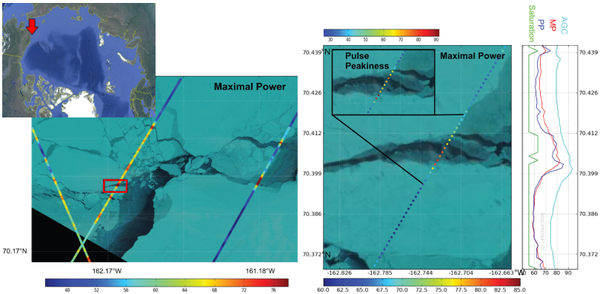
(Left) Maximal waveform Power (MP) spatial variability along Saral/AltiKa tracks (track 2 on 18 April 2013, track 985 on 17 April 2013 and track 918 on 15 April 2013) plotted over the LandsatLook Images of 17 April 2013.
(Middle) Zoom on the red rectangle of the left figure. The behavior of the Maximum waveform Power and the Pulse Peakiness (PP, on small insert) over a lead: the PP criteria is higher on the edges of the lead than in its middle.
(Right) The along-track variation of the MP follows the behavior of the Automatic Gain Control (AGC light blue curve), but without the typical delay of the AGC. MP doesn’t show any saturation over the lead and thus, is better suitable than the PP parameter . Credits Legos/CTOH.
Sea ice is frozen waters that covers ocean at high latitudes. During last years the ice extent in Arctic has drastically reduced and numerical models do not able reproduce this decreasing. Some mechanisms, that have not yet been taken into consideration in models probably could help us to explain the discrepancy between observations and models. Due to currents and winds, the ice field drifts. It results to ice deformation and to formation of crack - open water areas called leads and polynyas. Leads are narrow areas such as linear cracks while polynyas can reach tens kilometres in width.
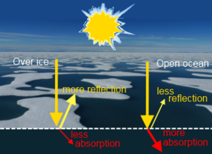
These open ocean surfaces are darker and reflect less sunlight back into space than ice surfaces. Oceans absorb more energy getting them warmer. Sea ice impacts also the ocean circulation thereby leading to changes in global climate. As sea ice forms, the salinity and the density of upper ocean layers increases. These salted polar waters sink, driving cold, deep ocean currents to the equator.
Satellite altimetry with high inclination orbit allowing an optimal coverage in high latitudes, enables to determine sea ice extent, thickness and volume. Saral/AltiKa by operating in a higher Ka-band frequency offers higher spatial resolution than the Ku-band radar altimeter and potentially better leads/polynyas measurements.
A detailed analysis of the Saral/AltiKa altimetric radar waveform (return echo shape) and its characteristic (leading edge, width trailing edge slope, backscatter) help to define a new algorithm based on the maximal power of waveforms to discriminate the leads in Arctic Ocean. A combination with optical images validate the procedure and help to adjust the thresholds used by the algorithm.
Large open water areas have lower backscatter in Ka-band as compared to calm narrow water / thin ice surfaces in small leads. Re-frozen or narrow leads and polynyas, are very specular and thus well observed by altimeter.
This method adapted for Saral/AltiKa well detect the leads /polynyas of small and medium size from 200 m to 3-4 km and can be applied from December until May.
See also:
- Applications: Ice and cryosphere
- Multimedia Galery: Sea ice topic
- Image of the month, April 2014: Melting in the Kara Sea
References:
- Zakharova E.A. et al. (2015) Sea Ice Leads Detection Using SARAL/AltiKa Altimeter. Marine Geodesy, Vol.38, Supp. 1, pp522-533. DOI: 10.1080/01490419.2015.1019655
News
 Archives .
- Aviso Newsletter .
- Search.
- Front-page news.
- Image of the month .
- 2026 .
- 2025 .
- 2024 .
- 2023 .
- 2022 .
- 2021 .
- 2020 .
- 2019 .
- 2018 .
- 2017 .
- 2016 .
- 2015 .
- Dec. 2015: Multi-year penguin tracking.
- Nov. 2015: Saral measures gaps in sea ice.
- Oct. 2015: A future insight to English Channel.
- Jul. 2015: El Niño's return, West side story.
- Jun. 2015: Current intruding on the continental shelf.
- May 2015: Better gravity with drifting orbits.
- Apr. 2015: Through Indonesia.
- Mar. 2015: High tides at Mont Saint-Michel.
- Feb. 2015: Small fishes in a big ocean.
- Jan. 2015: El Niño played hide and seek in 2014.
- 2014 .
- 2013 .
- 2012 .
- 2011 .
- 2010 .
- 2009 .
- 2008 .
- 2007 .
- 2006 .
- 2005 .
- 2004 .
- 2003 .
- 2002 .
- 2001 .
- 2000 .
- 1999 .
- 1998 .
- Operational news and status .