


Mean dynamic topography
Image of the Month - December 2019
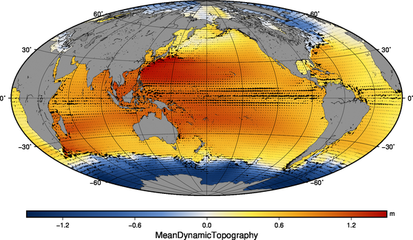
The sea surface height due to the mean ocean currents may seem an easy thing to determine - by definition, those are stable in time and space. But in fact, when using altimetry, we are working most of the time with height variations (aka sea level anomalies) or with heights with respect to a reference ellipsoid. The mean currents are within the multi-year mean of the latter (the mean sea surface), but together with the geoid. And, for a long time, the geoid was not well known. Now, with dedicated missions such as Goce, several years of Grace, its knowledge is better and better. Moreover, another approach can be used: measuring the surface currents using drifting buoys, to compute their mean flow. Or the two approaches can be combined, removing the geoid from the altimetry mean sea surface as a first step, then refining the result using the in situ data for finer details.
Since the first Mean Dynamic Topography dataset disseminated through Aviso, 15 years have gone by with several upgrades issued, and many improvements in quality and in the method used. The new CNES-CLS18 MDT is now available and shows huge improvements compared with the previous one, mainly in coastal areas and in western boundary currents.
See also:
- Applications: Large-scale ocean circulation
- Image of the Month, February 2003: Ocean currents
- Data / Auxilary: MDT
References:
- Sandrine Mulet, Marie-Hélène Rio, Hélène Etienne, Nicolas Picot, Gérald Dibarboure, 2019: New CNES-CLS18 Mean Dynamic Topography of the global ocean from altimetry, gravity and in-situ data, OSTST meeting, Chicago, Oct. 2019
- S. Mulet, 2019: New CNES-CLS18 Mean Dynamic Topography, Aviso Users Newsletter #16, p. 8
- Cancet, M., Griffin, D., Cahill, M., Chapron, B., Johannessen, J., Donlon, C., 2019. Evaluation of GlobCurrent surface ocean current products: A case study in Australia. Remote Sens. Environ. 220, 71–93. https://doi.org/10.1016/j.rse.2018.10.029
News
 Archives .
- Aviso Newsletter .
- Search.
- Front-page news.
- Image of the month .
- 2026 .
- 2025 .
- 2024 .
- 2023 .
- 2022 .
- 2021 .
- 2020 .
- 2019 .
- Dec. 2019: Mean dynamic topography.
- Nov. 2019: 2019 monsoon monitored using altimetry .
- Oct. 2019: Monitoring an iceberg topography with altimetry.
- Sep. 2019: Internal tides in the Solomon Sea change with ENSO phases.
- Aug. 2019: Fifty years ago....
- Jul. 2019: Increasing wave power.
- Jun. 2019: Modelling the flow.
- May 2019: Liguro-Provençal current seen by in situ instruments and altimetry.
- April 2019: Pantanal wetlands.
- Mar. 2019: Focusing on small water bodies.
- Feb. 2019: Sharks in eddies and meanders.
- Jan. 2019: From La Niña to El Niño, Aviso Image of the Month 20th birthday!.
- 2018 .
- 2017 .
- 2016 .
- 2015 .
- 2014 .
- 2013 .
- 2012 .
- 2011 .
- 2010 .
- 2009 .
- 2008 .
- 2007 .
- 2006 .
- 2005 .
- 2004 .
- 2003 .
- 2002 .
- 2001 .
- 2000 .
- 1999 .
- 1998 .
- Operational news and status .