


Altimetric assessment of the NMC ocean model
J. E. Harris, D. B. Enfield and N. J. Bravo (NOAA/AOML, USA)
As part of the NOAA Pan American Climate Studies program we are assessing the performance of the National Meteorological Center (NMC) ocean general circulation model (OGCM) using the TOPEX/POSEIDON (T/P) altimeter data. Preliminary results show good agreement in some areas of the Pacific, especially near the equator. Other areas show less agreement, which may shed light on problems associated with facets of the OGCM such as wind forcing, spatial resolution or internal parameterizations
Previous assessments of the NMC model using unassimilated in situ data include a comparison with Pacific tide gauges at island and coastal stations (Enfield and Harris, 1995). That study showed that the annual cycle and large-scale interannual variability were generally well simulated by two 11-year (1982-1993) monthly reanalyses over the interior of the tropical Pacific, except that variability along the eastern boundary was poorly reproduced. The monthly reanalysis forced by observed winds compared better than the one forced by the medium-range forecast model (MRF), suggesting that improvements in the MRF are needed. The evaluation of the OGCM performance in the eastern Pacific interior was compromised by the lack of tide gauges there. By comparing sea surface heights (SSH) from 10-day exact repeat cycles of the T/P altimeter with the dynamic heights from the weekly OGCM-based operational analyses ("nowcasts"), we hope to extend the Enfield and Harris results by taking advantage of the greater spatial resolution of the altimeter data and the greater temporal resolution offered by the nowcasts.
The T/P SSH data used are processed from the detided (Cartwright and Ray) geophysical data records (GDRs) by eliminating outliers and then spline-approximating along repeat tracks with the temporal mean transects and meridional trends (geoid plus mean oceanographic profile) removed. The model output fields used in this comparison are the near-real-time operational weekly ocean nowcasts produced by the Coupled Model Project at NOAA/NMC (Ji et al., 1995). The model domain is roughly 122°E to 72°W and 35°S to 45°N with 27 vertical levels. Both SST and subsurface temperature profiles from XBTs and TAO buoys are assimilated. The OGCM is forced by wind stress fields produced by a modified version of the MRF using analyzed SST observations as a lower boundary condition. The SSH fields from both the nowcasts and the altimeter were objectively interpolated to a common 1.5 degree longitude by 1 degree latitude grid centered on the weekly nowcast times for the calendar years 1993- 1994 (T/P cycles 11 - 84). The two-year mean SSH fields were removed to yield SSH residuals for both data sets. Variability potentially resolved includes the annual cycle, low-latitude interannual events and intraseasonal propagating events. The single most significant circulation feature within the data domain is the North Equatorial Countercurrent (NECC).
The rms differences between the two data sets (see figure 1) yield a mean value of 7.2 cm for the entire domain, decreasing to just under 5 cm between 5°N and 5°S. The basin scale distributions of variability compare well ; both maps show similar large scale features, such as variability maxima in the Kuroshio and West Australia Current regions, bands of high variability near 5-7°N and 10-12°N across much of the basin, and the quiescent subtropical regions west of North and South America. The lack of high SSH variability along the equator -- in either data set -- can be attributed to the very low magnitude of the Coriolis parameter there.
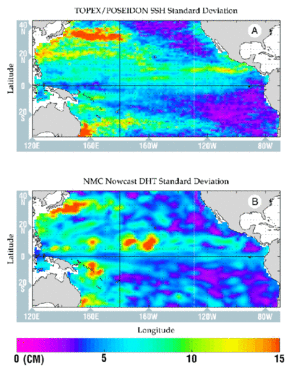
Figure 1 : Standard deviation of the sea surface (in cm) for 1993-1994 from
(A) TOPEX/POSEIDON sea surface height residuals
(B) nowcast model dynamic height anomalies relative to 1000 meters.
Notable discrepancies between the two data sets include nowcast underestimates of the eastward projection of high eddy potential energy in the Kuroshio Extension and east of Australia. The bulls-eyes of high nowcast variability near 160 W and 175 W along 5-10 N appear to be almost entirely associated with an extreme depression of the model thermal structure in late 1994.
From figure 2A, we can see that the SSH fields from the nowcast and altimetry are highly correlated along the equator and are above the 90% confidence level over much of the area between 10°S and 20°N. Except for the region within 2-3 degrees of the equator, most of the observed correlation is explained by the large amplitude of the annual harmonic (figure 2B). The areas of higher annual amplitude are better correlated and where the annual harmonic is weak (e.g., poleward of 10 S and 20 N) there is decreased correlation. The high correlations along the equator cannot be explained in this way because the annual harmonic is small there. Intraseasonal Kelvin waves in the absence of energetic background noise (e.g., as in Busalacchi et al., 1994) are the most likely source of this correlation, which suggests that the OGCM does reasonably well at capturing such events.
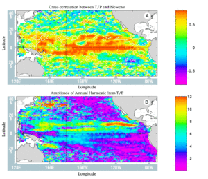
Figure 2 :
(A) Cross-correlation map of SSH residuals, T/P vs.the NMC nowcasts.
The contour of the 90% significance level is included.
Figure 3 :
(B) Amplitude (in cm) of the annual harmonic as computed from TOPEX/POSEIDON.
A Hovmuller diagram of the zonal-temporal variability of the NECC flow illustrates both good and bad aspects of the OGCM performance (see figure 3). We compute the zonal component of flow as the difference in SSH between 6 N and 12 N, scaled by the geostrophic relationship. These are residual velocities since the mean topography has been removed. Both the altimetry and the OGCM reproduce the seasonal nature of the NECC in much the same way. The NECC flow is maximum in the late boreal autumn and minimum in the late spring, as expected, and the annual signal propagates westward from the eastern boundary. The OGCM (figure 3B) reproduces rather poorly some of the event-like westward propagating variability found in the altimetry, especially evident in the eastern Pacific during the winter-spring season (figure 3A).
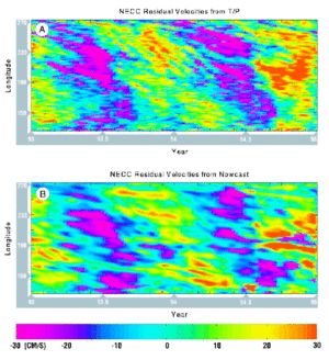
Figure 4 : Fluctuations of residual zonal velocity (in cm/s) in the NECC between 6 N and 12 N from :
(A) T/P SSH residuals
(B) nowcast dynamic height residuals.
These reduced-flow events correspond to topographic events of elevation that propagate westward along the northern hinge of the countercurrent near 11-12°N (not shown), thus decreasing the poleward downslope across the NECC. They correspond well in both propagation speed (16 cm/s) and season with the anticyclonic eddies seen in drifter and GEOSAT data by Hansen and Maul (1991) and Giese et al., (1994). They are probably produced in the Gulfs of Tehuantepec and Papagayo by the severe mountain-pass wind jets associated with cold airmass outbreaks over North America. However, the temporal resolution of these features is coarse in the OGCM and there is not a precise one-to-one temporal correspondence nor agreement of propagation speeds.
Conclusion
Preliminary comparisons between T/P altimetry and the NMC ocean model indicate that the latter realistically reproduces much of the annual variability from 10°S to 20°N, including the NECC flow across the basin, but does not fully resolve the westward propagating events in SSH that are clearly seen in the T/P data. Our next task is to investigate time scales and phenomena other than the annual cycle, such as eastward propagating variability along the equator, evidence of tropical instability waves near 5°N, and the possible existence of interannual basin modes identified by Enfield and Harris (1995).
References
- Busalacchi, A.J., M.J. Mc Phaden, J. Picaut, J. Geophys. Res., 99, 24725-24738 (1994).
- Enfield, D.B., J. Harris, J. Geophys. Res., 100, 8661-8675 (1995).
- Giese, B.S., J.A. Carton, L.J. Holl, 1994. J. Geophys. Res., 99, 24739-24748 (1994).
- Hansen, D.V., G.A. Maul, J. Geophys. Res., 96, 6965-6979 (1991).
- Ji, M., A. Leetma, J. Derber, Mon Weather Rev., 123, 460-481 (1995).
News
 Archives .
- Aviso Newsletter .
- Newsletter 1 .
- Newsletter 2 .
- Newsletter 3 .
- Newsletter 4 .
- Vision and determination.
- ELFE : an orbit is born .
- Sea level variability in the Mediterranean .
- Gulf Stream predictions assessed with TOPEX/POSEIDON data .
- Seasonal variations.
- Validating model simulations.
- Altimetric assessment.
- Operational use of TOPEX/POSEIDON data.
- Validating T/P Significant Wave Heights.
- World Wave Atlas.
- Improving model wave fields.
- Newsletter 5 .
- Newsletter 6.
- Newsletter 7 .
- Newsletter 8.
- Newsletter 9.
- Newsletter 10.
- Search.
- Front-page news.
- Image of the month .
- Operational news and status .