


Operational use of TOPEX/POSEIDON data at METEOMER
METEOMER, France
METEOMER, a company specialising in real-time assistance for marine engineering, has been using satellite data such as wave-mode SAR, scatterometer and altimeter data operationally for several years. We use the data both to make our forecasting more reliable and to determine meteorological-oceanographic sizing parameters for engineers. This article provides some examples of how we use TOPEX/POSEIDON data operationally.
The signals transmitted by an altimeter radar are reflected back from the sea surface. In waves and ripples, the reflected signal is distorted and some of the energy is scattered. Analysing the shape of the return signal and the backscattered power yields the significant wave height (Hs) and surface wind speed modulus. The last two parameters are commonly used in marine engineering.
METEOMER, as an operational service provider, uses the measurements of Hs supplied by TOPEX/POSEIDON to:
- hindcasting events such as storms,
- supply climatologies of sea-state parameters,
- obtain extreme Hs values by extrapolation.
We also uses the Hs and wind speed measurements supplied by TOPEX/POSEIDON to validate ERS-1 wave mode SAR.
Hindcasting events such as storms
Storms can be studied from individual TOPEX/POSEIDON tracks. Altimeter tracks improve the quality of wind fields used as inputs to assimilation-based swell forecasting models, and yield direct measurements of the events to study.
TOPEX/POSEIDON data therefore let us initialize the wind fields both directly, by inputting measured wind speeds to the model, and indirectly, by correcting wind fields to optimise the wave heights derived from the model with respect to TOPEX heights.
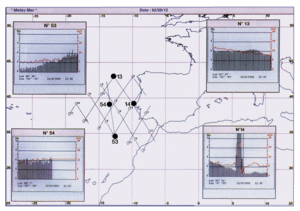
Figure 1 : Sea-state conditions (Hs is in m., wind speed in m/s.) off Portugal during the 1993/09/12 storm. ERS-1 and TOPEX/POSEIDON altimeter tracks are overlaid
To obtain direct measurements of events, using TOPEX/POSEIDON data in addition to altimeter and ERS-1 SAR data can be critical, as the inclination of its tracks, which are more zonal than those of ERS-1, sometimes improves the analysis. Figure 1 shows sea- state conditions off Portugal that vary more quickly than ERS-1 tracks and models can reveal.
Supplying climatologies of sea-state parameters
Until recently, the main source of coastal meteorology-oceanography data was visual shipboard observations and occasional in situ measurements. Turning to the statistical use of altimeter data for climatological purposes, work by METEOMER in CLAROM (an association doing work on and research into marine features) has shown that Hs climatologies are equivalent in terms of quality and cost to those derived from in_situ data, and available more quickly.
Work has been done both on methods (i.e. setting geographical limits for the representativeness of altimeter tracks in particular study areas), and into the statistical corrections that may be needed when dealing with measurements from different sources (GEOSAT, ERS-1 and TOPEX/POSEIDON). We have also developed semi- automated procedures for detecting and removing deviant values. In operational situations this increases reliability and the homogeneity of the results.
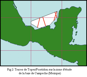
Figure 2 : TOPEX/POSEIDON altimeter tracks in Campeche Bay, Mexico
Thanks to high-accuracy, global coverage and all-weather capability, measurements from onboard altimeters such as TOPEX/POSEIDON have revolutionised climatological methods and ideas. Since August 1992 the mission has been offering us a fantastic opportunity to increase data density, providing statistics in areas as small as 1 square. Figure 2 is an example of a local area defined in Campeche Bay, Mexico.
Deriving extreme Hs values
Extrapolating Hs values from a sampled observation period to the most likely extreme values over the different time-scales of a project, typically 10, 20, 30, 50 and 100 years, is a key step in sizing a structure or feature subject to wave action. In particular, it requires a good estimate of the range of high values in the initial sample.
By increasing the amount of data and therefore the quality of the range of high values, TOPEX/POSEIDON is therefore likely to open up scope for using quality extrapolation procedures.
Validating ERS-1 wave mode SAR data inversion procedures
The ERS-1 Synthetic Aperture Radar (SAR) provides a unique means of gathering global information on sea-state periods and directions. Unfortunately, using the data in meteorology-oceanography requires an inversion model for the raw data.
Validating such a procedure can be difficult. The problem soon arises of how to co- locate in situ and SAR data. TOPEX partly overcomes the problem. In the North Atlantic we obtained 200 pairs of Hs measurements derived from TOPEX/POSEIDON altimeter tracks crossing over ERS-1 SAR measurements over periods typically shorter than one hour. We used the data to optimise the parametrisation of a semi-empirical transfer function of the inversion, setting SAR Hs values according to the altimeter outputs. The wind speed and fluctuation information also increased our knowledge of the SAR imagery.
Conclusion
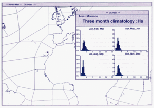
Figure 3 : Using CLIOSAT : three-month sea-state climatology of significant wave height (Hs) off the Moroccan coast
METEOMER, in collaboration with IFREMER, has produced a global database of marine environmental parameters (Hs, wind speed and direction, swell period and direction) including all the satellite data available from the GEOSAT, ERS-1 and TOPEX/POSEIDON altimeters, and from the ERS-1 SAR and scatterometer. The project, called CLIOSAT (CLImatological Oceanic SATellite), is supported by the French Space Agency (CNES) and has now reached a conclusion. In December 1995, an atlas of general climatologies for PCs has been made commercially available. An on-line service is developed to provide statistics of marine environmental parameters for user-defined areas and times, within 24 hours. Figure 3 shows an example of CLIOSAT data off the Moroccan coast.
News
 Archives .
- Aviso Newsletter .
- Newsletter 1 .
- Newsletter 2 .
- Newsletter 3 .
- Newsletter 4 .
- Vision and determination.
- ELFE : an orbit is born .
- Sea level variability in the Mediterranean .
- Gulf Stream predictions assessed with TOPEX/POSEIDON data .
- Seasonal variations.
- Validating model simulations.
- Altimetric assessment.
- Operational use of TOPEX/POSEIDON data.
- Validating T/P Significant Wave Heights.
- World Wave Atlas.
- Improving model wave fields.
- Newsletter 5 .
- Newsletter 6.
- Newsletter 7 .
- Newsletter 8.
- Newsletter 9.
- Newsletter 10.
- Search.
- Front-page news.
- Image of the month .
- Operational news and status .