


Sea level variability in the Mediterranean
P.Y. Le Traon, G. Larnicol (CLS, France), N. Ayoub, P. De Mey (GRGS/UMR39, France)
Three years of Topex/Poseidon (T/P) data were analysed in the Mediterranean as part of the European MAST Mermaids-II project. The project aims to improve our knowledge of the circulation and marine ecosystems in the Mediterranean. The contribution of our group (GRGS/UMR39 and CLS) focuses on analysing T/P and ERS-1 data and assimilating them in a numerical model. The main results (mean level, ocean circulation, assimilation) are illustrated below.
Mean sea level in the Mediterranean
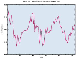
Figure 1 : Mean sea level (in m) in the Mediterranean, October 1992 to August 1995 (Topex/Poseidon cycles 2 to 106).
Analysing T/P data in the Mediterranean is, for the first time, providing a way of characterizing changes in the mean level of the Mediterranean (Larnicol et al., 1995). Figure 1 shows the trend calculated from almost three years of data (October 1992 to August 1995, i.e. cycles 2 to 106).
All necessary altimetric corrections were applied, including inverse barometer effect, and we used the latest JGM3 orbits. There is strong variation, on the order of 20 cm, peaking in October-November, falling quickly in January/February, and reaching a minimum in March/April. The marked seasonal cycle is slightly weaker in the third year. Roughly half the signal is related to the steric effect of contraction/dilation of the sea surface driven by heat exchanges at the ocean-atmosphere interface. The other half is probably due to a slight seasonal imbalance between incoming and outgoing flows off Gibraltar, and to evaporation and precipitation. This suggests that mass in the Mediterranean is not conserved at seasonal scale. Analysing the differences in level between the Atlantic and the western basin, and between the western and eastern basins, also reveals seasonal variations in the flows into the straits of Gibraltar and straits of Sicily.
Le Traon and Gauzelin did a dedicated study into the effect of atmospheric pressure on mean sea level. The Mediterranean response to atmospheric pressure is unusual, in that the adjustment to pressure leads to an exchange in the straits of Gibraltar: the presence of a mean anticyclonic pattern will only induce a fall in mean level if the water can “escape” via the strait. In practice, at high frequencies the adjustment seems limited by friction in the strait. The high-frequency response will therefore be noticeably different from a simple inverse barometer effect (which would be the same for the lowest frequencies, particularly at the seasonal frequency discussed above). This was highlighted by a consistency analysis based on T/P data. The analytical model put forward by Candela (1991), which includes friction in the straits of Gibraltar and Sicily, was successfully applied to T/P data. We showed that it better corrects mean sea level for high-frequency pressure effects.
Ocean circulation
Figure 2 represents the variations in dynamic topography observed by T/P from October 1992 to March 1995. The maps are averaged over three-month periods. The scale is from -7 cm (blue) to + 7 cm (red). The figure shows (Larnicol et al., 1995) the main characteristics of the Mediterranean circulation (Alboran gyres; Algerian eddies; Ionian, Ierapetra and Mersa-Matruh gyres, etc.) and the seasonal and interannual variations in these features (strengthening of cyclonic circulation in winter; strengthening of anticyclonic Alboran and Ierepetra gyres in summer and autumn).
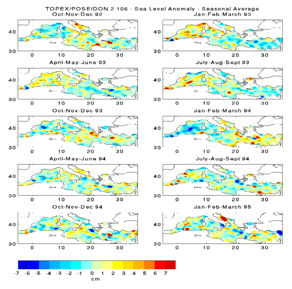
These results agree well with what we know about circulation in the Mediterranean. T/P reveals some of the particularly strong signals, e.g. Alboran gyres east of Gibraltar and Ierepetra gyre south-east of Crete, very well. In particular, it shows the strong seasonal signal from the Ierapetra gyre. This signal is probably linked to direct forcing by strong Estonian winds, which interact with the Cretan topography. T/P data are now being used to validate Mediterranean circulation models.
A lot of work on merging T/P and ERS-1 has also been started to obtain a finer-mesh description of the circulation (Ayoub et. al., 1995). T/P is being used to benchmark ERS-1 data, which have high orbital errors relative to the ocean signal. Merging the data is vital for monitoring mesoscale signals in the Mediterranean, e.g. Algerian eddies.
Assimilation
The purpose of assimilating altimeter data into a primitive equation model (the GFDL-MOM model) is to provide a three-dimensional description of Mediterranean circulation. GRGS/UMR 39 uses a sequential method based on conventional optimal interpolation. The model is integrated over two weeks and provides a forecast. A correction is calculated from the two-week differences between model and data. The correction is calculated to meet the geostrophic constraints, filter out gravity waves and monitor the statistical vertical profiles (orthogonal empirical modes). The details of the method appear in De Mey and Benkiran (1995).
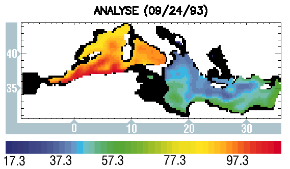
Figure 3 is a typical analysis for 24 September after assimilating merged T/P and ERS-1 data. The figure shows the dynamic topography relative to a deep level. The difference between the basins is due to the contrast in density. Main characteristics of Mediterranean circulation, from west to east: Alboran jet and its meanders, the Algerian current, Ionian current and mid- Mediterranean jet. A large anticyclonic eddy close to Sardinia and the Ierepetra gyre south- east of Crete can also be seen.
Prospects
T/P has shown the unique contribution satellite altimetry can make to studying the Mediterranean: monitoring the mean level, flows in the straits, and ocean circulation. These measurements will be valuable indicators of possible climate changes in the Mediterranean basin. They will allow us to validate ocean circulation models and drive them significantly via assimilation. Several altimeters are operating or will operate simultaneously in the coming decade : T/P, ERS-1, ERS-2, Geosat Follow-On, Envisat, T/P Follow-On. We will be able to observe the Mediterranean with very good space-time sampling and high accuracy, especially with T/P and later T/P Follow-on which could be benchmarks for the other missions. This should eventually lead to an “operational” system to monitor the Mediterranean.
References
- Ayoub N., P.Y. Le Traon, P. De Mey, Combining ERS-1 and Topex/Poseidon for observing the oceanic circulation in the Mediterranean sea, submitted to J. Marine Sys. (1995).
- Candela J., Dynamics of Atmospheres and Oceans, 15, 267-300 (1991).
- De Mey P., M. Benkiran, Optimal interpolation in the Mediterranean, in preparation to J. Marine Sys. (1995).
- Larnicol G., P.Y. Le Traon, P. De Mey, J. Geophys. Res., 100, 25, 163-25, 177 (1995).
- Le Traon P.Y., P.Gauzelin. Response of the Mediterranean mean sea level to atmospheric pressure forcing, in preparation (1995).
News
 Archives .
- Aviso Newsletter .
- Newsletter 1 .
- Newsletter 2 .
- Newsletter 3 .
- Newsletter 4 .
- Vision and determination.
- ELFE : an orbit is born .
- Sea level variability in the Mediterranean .
- Gulf Stream predictions assessed with TOPEX/POSEIDON data .
- Seasonal variations.
- Validating model simulations.
- Altimetric assessment.
- Operational use of TOPEX/POSEIDON data.
- Validating T/P Significant Wave Heights.
- World Wave Atlas.
- Improving model wave fields.
- Newsletter 5 .
- Newsletter 6.
- Newsletter 7 .
- Newsletter 8.
- Newsletter 9.
- Newsletter 10.
- Search.
- Front-page news.
- Image of the month .
- Operational news and status .