


Surface Measurements for Oceanographic Satellites: the SUMOS in-situ and airborne campaign
Image of the Month - July 2021
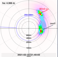
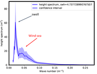
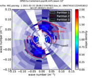
First results from the SUMOS campaign: (left) 2D directional wave spectrum from the SPOT014 drifting buoy; (center) 1D directional wave height spectrum from SWIM instrument on board CFOSAT; (right) 2D slope spectrum from the SWIM instrument on board CFOSat (Credit LATMOS)
CFOSat has been launched on October, 29th 2018. It is providing operational wind and wave data, but improvements and a better understanding of the provided information would be useful.
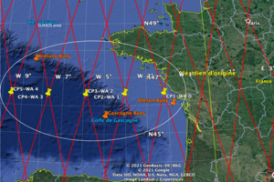
SUMOS campaign was carried out in the Bay of Biscay in February and March 2021. It was designed to collect a set of co-located observations of wind, waves and associated parameters (turbulent air-sea fluxes) by both in-situ and remote sensing means. The resulting data will be used to:
• improve CFOSat mission data inversion methods,
• better identify the performance and limits of the parameters provided by CFOSat,
• advance mission objectives concerning the study of wave hydrodynamics and wind/wave/flux relationships in turbulent conditions.
The campaign also took advantage of the SKIM mission for multiscale monitoring of sea surface kinematics to acquire Ka-band Doppler radar scatterometry data via Ka-band Radar for Surface Currents Measurements (KaRADOC, an instrument developed by the Institut d'Electronique et des Technologies du numéRique (IETR)) to support concepts for future satellite missions using this technique.
The campaign's scientific coordination was ensured by Peter Sutherland (LOPS, Ifermer) and Danièle Hauser (Laboratoire Atmosphères, Observations Spatiales (LATMOS), Paris) for SUMOS and Stéphane Meric (Institut d'Electronique et des Technologies du numéRique (IETR), Rennes, France) and Louis Marie (LOPS, Ifermer) for SKIM with strong backing from the CNes team.
Two national experimentation platforms were deployed in and over the Bay of Biscay:
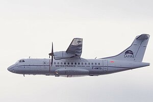
- F-HTMO, the research aircraft operated by the French facility for airborne research, SAFIRE (Météo France/CNRS/Cnes)
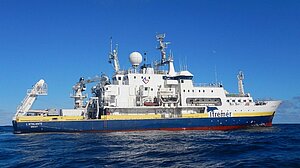
- French Oceanographic Fleet's L’Atalante research vessel operated by the Genavir economic interest group.
Data were acquired using these two platforms in coordination with CFOSat passes over the Bay of Biscay. The operating plan included:
- in-situ measurements of waves (directional spectra), wind and turbulent fluxes using 20 drifting buoys (including SPOT014) and 3 flame buoys deployed by L'Atalante.
- measurements taken on board the ship itself using in particular an imaging radar operated by Germany’s Helmholtz-Zentrum Geesthacht for directional spectrum of the waves and surface currents measurements and polarimetric image acquisitions with a stereo video camera to measure wave and surge characteristics.
- airborne measurements using:
- Ku-band Radar for Observation of Surfaces (KuROS) developed and operated by LATMOS to provide directional wave spectra in addition to information on the surface wind and radar backscattering cross-section.
- Ka-band Radar for Surface Currents Measurements (KaRADOC) developed and operated by the IETR.
See also:
- Missions: CFOSat
- Data: CFOSat
- Applications: Wind and waves
Other web sites on this topic:
- CFOSat on CNES web site
- the campaign data via the Odatis service
News
 Archives .
- Aviso Newsletter .
- Search.
- Front-page news.
- Image of the month .
- 2025 .
- 2024 .
- 2023 .
- 2022 .
- 2021 .
- Dec. 2021: FSLEs help to forecast oil spill dispersion.
- Nov. 2021: AI learning method to improve altimetry gridding.
- Oct. 2021: Snow on sea ice.
- Sep. 2021: A buoy spiraling over Burdwood Bank.
- Aug. 2021: Understanding phytoplanktonic plumes around the Marquesas Islands.
- Jul. 2021: Surface Measurements for Oceanographic Satellites: the SUMOS in-situ and airborne campaign.
- June 2021: Swot and the lakes' winds.
- May 2021: Typhoon Surigae in the eyes of radars.
- Apr. 2021: Swot simulations of Sahelian ponds and lakes.
- Mar. 2021: Eddies are spreading salt in the ocean.
- Feb. 2021: Altimetry helps to monitor the Congo basin.
- Jan. 2021: A new "First light" in the Jasons' family.
- 2020 .
- 2019 .
- 2018 .
- 2017 .
- 2016 .
- 2015 .
- 2014 .
- 2013 .
- 2012 .
- 2011 .
- 2010 .
- 2009 .
- 2008 .
- 2007 .
- 2006 .
- 2005 .
- 2004 .
- 2003 .
- 2002 .
- 2001 .
- 2000 .
- 1999 .
- 1998 .
- Operational news and status .