


Typhoon Surigae in the eyes of radars
Image of the Month - May 2021
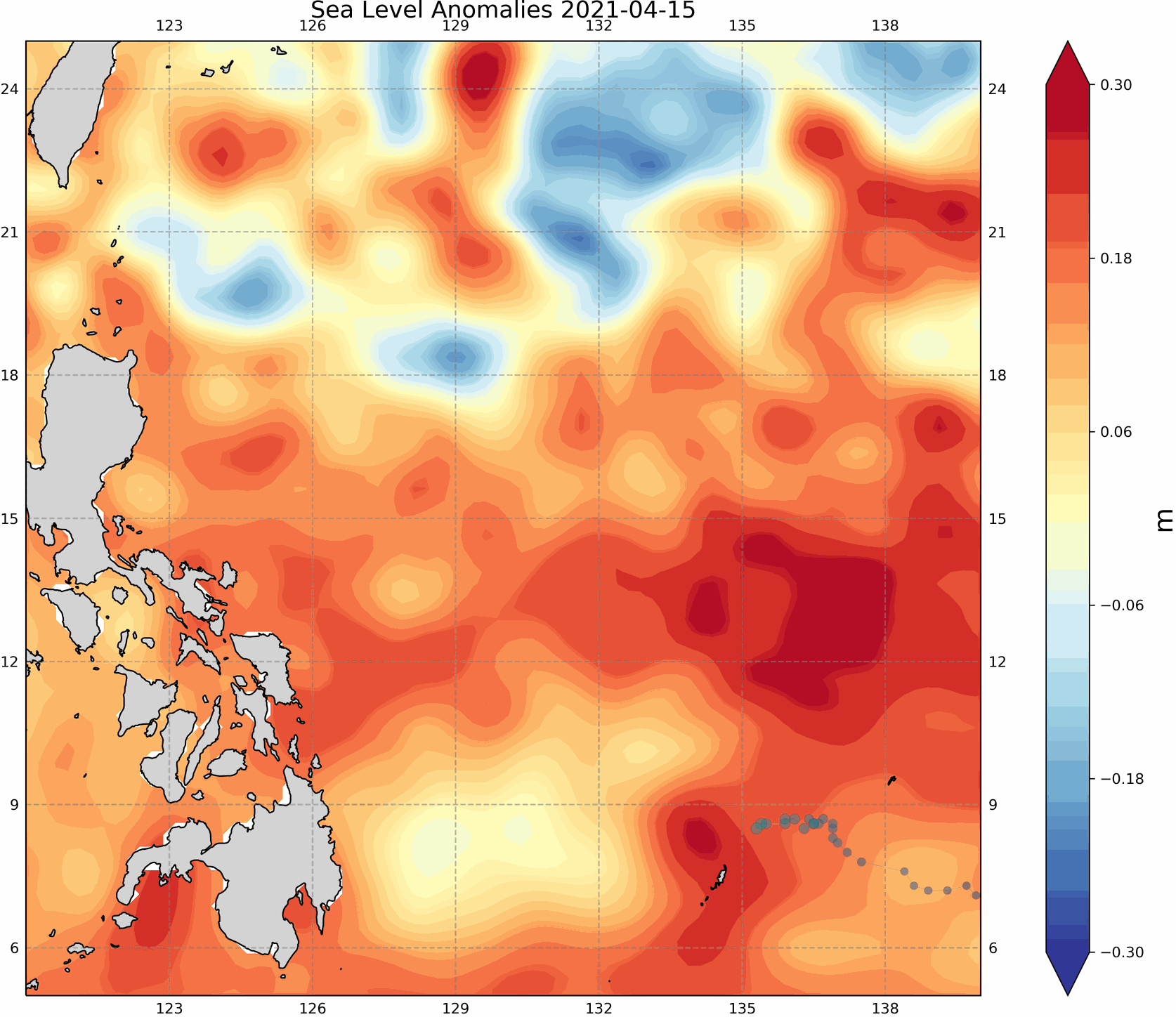
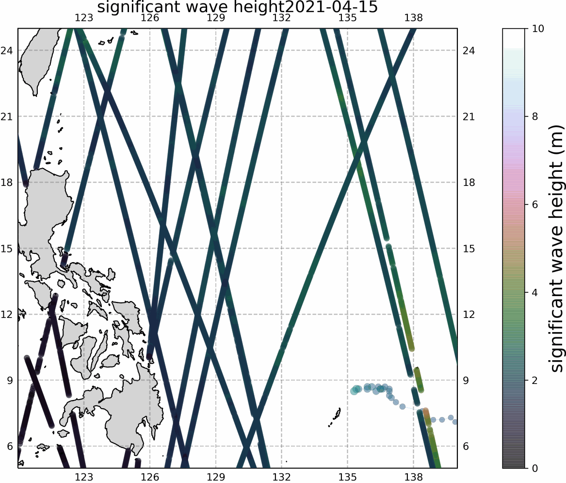
Left, Sea level anomalies with Surigae track overlaid (color and size-coded with respect to measured wind speed) on April 20, 2021. The typhoon winds dropped slightly after going over a lower-than-average sea surface height area, probably due to it being colder. (see the Animation from April 13 to April 24, 2021). Right, Level-3 Significant Wave Height and the tropical cyclone tracks (dots, same color-coding than the SLA map). The highest retrieved significant wave heights are around 10 m (see the Animation from April 15 to April 24) (SLA: Level-4, SWH: Level-3 Marine Copernicus Service data from altimeters - all available operational satellites: Saral, CFOSat, Cryosat-2, HY-2B, Jason-3, Sentinel-3A, Sentinel-3B ; typhoon track from Japan Meteorological Agency Best Track Data. Plotting Aviso).
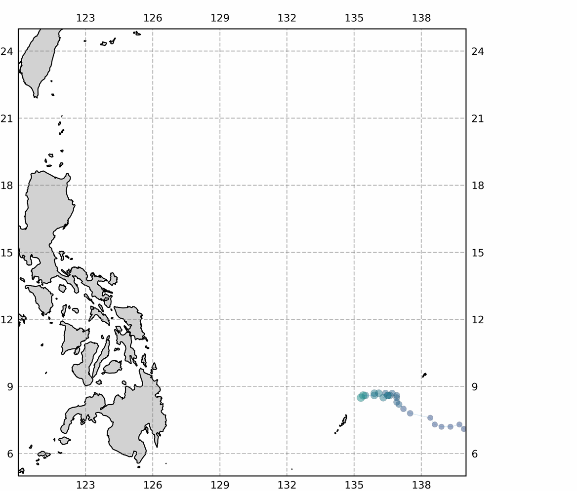
Typhoon Surigae hit the North-Western Pacific last month (April 13-25, 2021). It was the strongest typhoon on record in April, with an impressive diameter of more than 110 km at its widest, sustained winds reaching 220 km/h with gusts at more than 300 km/h. It was of course monitored by the meteorological satellites, but other satellites also took some measurements - altimetry satellites among others. Luckily, it kept mostly over the ocean so did not have too many impacts on lands.
Altimetry can help tropical cyclones forecasting on two quite different aspects. The first and most evident is the measurements of significant wave height and wind speed, allowed by the analysis of the backscattered echoes' slope and power, measured back by the onboard altimeter after reflection on the ocean surface. Those can be assimilated in forecasting models, and used to validate and/or improve them in regions where there might not be a lot of in situ measurements, and possibly even less during such extreme phenomena. Another is the fact that Sea Level Anomalies, measured at the surface, are reflecting the underlying heat content, which is the fuel of such storms.
A number of other satellites are observing such phenomena, and their data are also used to improve forecasting. The Synthetic Aperture Radar satellites Sentinel-1A & B, part of the EU Copernicus constellation, provide with such information with dedicated programming by ESA teams. Those satellites are giving more localized measurements, with much more resolution. They are also enabling retrieval of very high winds and a precise image of the typhoon eye, showing even for the strongest a second temporary eyewall (seen on Surigae on e.g., on April 17-18).
Combining satellites and techniques, improving existing techniques and adding new ones enable to have a multi-perpective view on extreme phenomena, andand thus to better characterize the air-sea interactions during those (see [Combot et al., 2020] and possibly to help forecasting cyclone track and intensity. CFOSat in particular show a lot of promises in observing both waves and winds over tropical cyclones, and assimilating them in models (see [Yurovskaya et al., 2021]).
See also:
- Image of the Month, Oct. 2016: A typhoon seen by satellites
- Image of the Month, Nov. 2013: Typhoon Haiyan seen by Saral
- Image of the Month, Aug. 2013: 20 years of typhoons
- Applications: Marine meteorology and atmospheric studies
- Applications: Hurricane Katrina intensification
Other information on this topic:
- CYclone Monitoring Service based on Sentinel-1, an ESA project led by CLS and Ifremer to implement a strategy to monitor Tropical Cyclones using Synthetic Aperture Radar satellites
- Clément Combot, Yves Quilfen, Alexis Mouche, Jérôme Gourrion, Clément de Boyer Montégut, Bertrand Chapron, Jean Tournadre, 2020: Space-based observations of surface signatures in the wake of the 2018 Eastern Pacific tropical cyclones, In: Copernicus Marine Service Ocean State Report, Issue 4, Journal of Operational Oceanography, 13:sup1, s88–s91; DOI: 10.1080/1755876X.2020.1785097
- Maria Yurovskaya, Vladimir Kudryavstev, Alexey Mironov, Alexis Mouche, Bertrand Chapron, 2021: Combined CFOSAT SWIM and SCAT measurements: a tropical cyclone case study, CFOSat Science Team meeting (virtual).
News
 Archives .
- Aviso Newsletter .
- Search.
- Front-page news.
- Image of the month .
- 2026 .
- 2025 .
- 2024 .
- 2023 .
- 2022 .
- 2021 .
- Dec. 2021: FSLEs help to forecast oil spill dispersion.
- Nov. 2021: AI learning method to improve altimetry gridding.
- Oct. 2021: Snow on sea ice.
- Sep. 2021: A buoy spiraling over Burdwood Bank.
- Aug. 2021: Understanding phytoplanktonic plumes around the Marquesas Islands.
- Jul. 2021: Surface Measurements for Oceanographic Satellites: the SUMOS in-situ and airborne campaign.
- June 2021: Swot and the lakes' winds.
- May 2021: Typhoon Surigae in the eyes of radars.
- Apr. 2021: Swot simulations of Sahelian ponds and lakes.
- Mar. 2021: Eddies are spreading salt in the ocean.
- Feb. 2021: Altimetry helps to monitor the Congo basin.
- Jan. 2021: A new "First light" in the Jasons' family.
- 2020 .
- 2019 .
- 2018 .
- 2017 .
- 2016 .
- 2015 .
- 2014 .
- 2013 .
- 2012 .
- 2011 .
- 2010 .
- 2009 .
- 2008 .
- 2007 .
- 2006 .
- 2005 .
- 2004 .
- 2003 .
- 2002 .
- 2001 .
- 2000 .
- 1999 .
- 1998 .
- Operational news and status .