Mobile version

Sea surface heights in a part of the Gulf Stream off the coasts of America seen by Swot
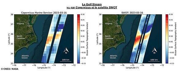
KaRIn ocean topography data of the Gulf Stream mapped as two wide, coloured strips spanning a total swath of 120 kilometres. Red and orange areas in the image represent sea levels higher than the global average, while blue shades represent sea levels lower than the average. This imagery exhibits a significant improvement in resolution over other altimetry satellites already in orbit, revealing ocean dynamics and the amplitude of eddies for the first time over a period of several days, thanks to the daily revisits afforded by Swot's calibration orbit. The clarity of the data illustrates the dramatic evolution in the technology used to measure sea-surface height from space. The spatial resolution of the Swot ocean measurements is 10 times greater than a composite of sea-surface height data over the same area from seven other satellites currently in operation: Sentinel-6 Michael Freilich, Jason-3, Sentinel-3A and 3B, Cryosat-2, AltiKa and Hai Yang 2B. (Credit Cnes/JPL, Copernicus Marine Service)

EnglishFrançais
Rss feedsContactPartnersFAQLexiconLegal noticePersonal Data Protection PolicyMobile
You must enable cookies in your browser preferences to save the modifications
You are using an older version of Internet Explorer, please update to take full advantage of Aviso+ features

Customize the home page

View all widgets
Reduce display
Public profile
User profile

Select/Deselect widgets

Discover AVISO+

Customizable home, reading tools, products search guide, etc.. Discover step by step the features of the new site AVISO+.

Customizable homepage

This home page is composed of blocks called "widgets".

Rearrange the blocks with a "Click & Drop".

Hide a widget with the cross at the top right. Reset or add a widget with the "wrench" icon. The "User" and "Public" profiles offer a predefined organization.

All the modifications are automatically saved as cookies on your machine so as to enable you to have your own specific AVISO+.

Reading tools

Ease your reading by choosing the page background colour (black/white) and/or by modifying the font size.

Browsing menu and breadcrum trail

To ease your browsing through AVISO+, you can use at any time the main banner items with the interactive submenus or use the browsing menu on the left side of the screen (it is open by default). For more readiness of the page contents, you can fold and unfold the browsing menu by clicking on the tab. At any time you can know where you are thanks to the browsing menu or the breadcrum at the top of the page.

Products search guide

The first submenu of the "Data" banner item leads you to a new search form enabling you to find quickier the product that suits your needs. The list of results is updated according to your selection criteria.

AVISO+ Multimedia

The first submenu of the "Multimedia" banner item leads you to AVISO+ collections of images and videos linked to altimetry and its applications. Have a nice visit!