


Several altimetry satellites for ocean forecasts
Image of the month - July 2005
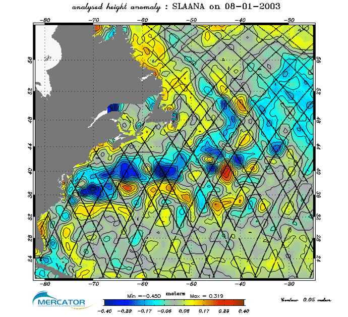
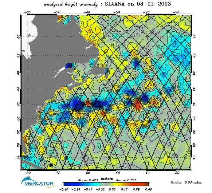
Sea level anomalies on January 8, 2003 from Medium-resolution Mercator model (1/3°), with assimilation of in situ, SST measurements and, left only Jason-1 data, right all available altimetry satellite data (Jason-1, ERS-2 et GFO). More details can be seen on the right-hand figures. Differences between the two can reach 10 cm, mostly between Jason-1 ground tracks (black lines). (Credits Mercator Océan)
Ocean forecasting models, like their meteorological cousins, are in need of measurements to stay as close as possible to reality. Satellite altimetry measurements are the most invaluable dataset for that mean, due to what they represent in term of ocean dynamics, but also since they are well-known and independant from cloud-cover. But, here also, several altimeters are better than one! Forecast quality, in resolution as well as in accuracy, is improved by assimilating data from several altimetry satellites at the same time.
Mercator project, which celebrated its 10th anniversary on June 26, 2005 is one of the operational oceanography projects that are been developed all around the world. All of them use altimetry data, which are, with in situ data and models the basis of this "ocean weather". Their applications, from pollution drifting forecasts to seasonal climate prediction, and contribution to coastal and ecosystem models, give the inputs for future "ocean reports".
See also:
- Applications: Forecasting the ocean
- Altimetry: High-precision altimetry with satellites working together
Websites on this subject:
News
 Archives .
- Aviso Newsletter .
- Search.
- Front-page news.
- Image of the month .
- 2026 .
- 2025 .
- 2024 .
- 2023 .
- 2022 .
- 2021 .
- 2020 .
- 2019 .
- 2018 .
- 2017 .
- 2016 .
- 2015 .
- 2014 .
- 2013 .
- 2012 .
- 2011 .
- 2010 .
- 2009 .
- 2008 .
- 2007 .
- 2006 .
- 2005 .
- Dec. 2005: Atmosphere puts pressure on the ocean.
- Nov. 2005: Forecasting at oceans' scale.
- Oct. 2005: Cryosat, an altimeter over ice.
- Sep. 2005: Estimating Sea Surface Salinity.
- Aug. 2005: Satellites shed light on the Kon Tiki story.
- Jul. 2005: Several altimetry satellites for ocean forecasts.
- Jun. 2005: Cloudy skies.
- May 2005: Warm and cold eddies part ways.
- Apr. 2005: Series of hurricanes.
- Mar. 2005: Floats everywhere.
- Feb. 2005: Brazil-Malvinas confluence.
- Jan. 2005: Current heat.
- 2004 .
- 2003 .
- 2002 .
- 2001 .
- 2000 .
- 1999 .
- 1998 .
- Operational news and status .