


Merging of altimetry data: proofs from other measurements
Image of the month - January 2006
The utility of merging together the data from several altimetry satellites can be demonstrated using altimetry data only. Such an interest can also be shown by comparing the altimetry merged datasets with other, independent kinds of data, like sea surface temperature, or in situ measurements.
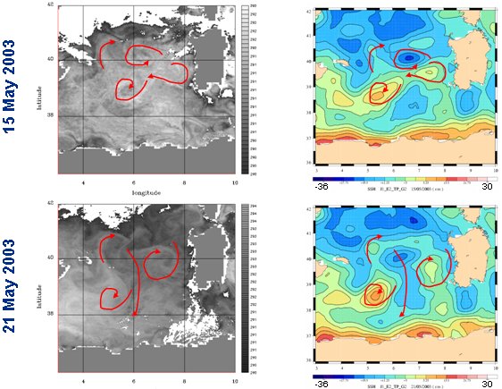
Data merging from several altimetry satellites allows to observe finer details in ocean features, like eddies, which are of a major importance for many altimetry applications today.
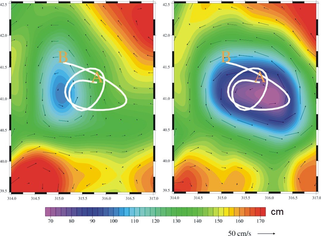
Buoy trajectory (white line, from May 14 to 28, 2003, from A to B), and merged absolute dynamic topography in the Gulf stream on May 21, 2003. Left with "only" two satellites, right with four satellites. The left map fit better the eddy materialized by the buoy path. (Credits CLS)
See also:
- Data: Ssalto/Duacs Products (Data Unification and Altimeter Combination System)
- Altimetry : High-precision altimetry with satellites working together
- Image of the Month, september 2004 : Four satellites to watch over the Mediterranean
References:
- Pascual, A., M-I Pujol, G. Larnicol, P-Y Le Traon, M-H Rio, 2005: Mesoscale Mapping Capabilities of Multisatellite Altimeter Missions: First Results with Real Data in the Mediterranean Sea. J. Mar. Sys. (in press)
- Pascual, A., Y. Faugère, G. Larnicol, P-Y Le Traon, 2006: Improved description of the ocean mesoscale variability by combining four satellite altimeters. Geophys. Res. Lett., 33, L02611, doi:10.1029/2005GL024633
News
 Archives .
- Aviso Newsletter .
- Search.
- Front-page news.
- Image of the month .
- 2026 .
- 2025 .
- 2024 .
- 2023 .
- 2022 .
- 2021 .
- 2020 .
- 2019 .
- 2018 .
- 2017 .
- 2016 .
- 2015 .
- 2014 .
- 2013 .
- 2012 .
- 2011 .
- 2010 .
- 2009 .
- 2008 .
- 2007 .
- 2006 .
- Dec. 2006: Five years in orbit for Jason-1.
- Nov. 2006: Argonautica buoys around a Tehuantepec eddy.
- Oct. 2006: Altimeter looks into the crevasses.
- Sep. 2006: Mediterranean currents.
- Aug. 2006: a multi-sensor's view on biology.
- Jul. 2006: Closer to the coasts.
- Jun. 2006: Tehuantepec eddies.
- May 2006: Ice on Lake Baikal.
- Apr. 2006: Beacons in the waveforms.
- Mar. 2006: A long way to paddle home for a green turtle.
- Feb. 2006: Heat moves with the eddies.
- Jan. 2006: Merging of altimetry data: proofs from other measurements.
- 2005 .
- 2004 .
- 2003 .
- 2002 .
- 2001 .
- 2000 .
- 1999 .
- 1998 .
- Operational news and status .