


Five years in orbit for Jason-1
Image of the month - December 2006
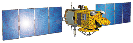
Five years ago, on December 7, 2001, Jason-1 (Cnes/Nasa) was put on orbit by a Delta II rocket from the Vandenberg base, in California. This launch marked the end of a story, begun in 1993 with the decision of the mission, and the start of a new one, which is still ongoing.
Since this date, the harvest of results is continue, with in particular:
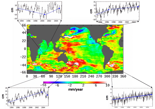
- long-term studies (mean sea level measurements, monitoring of phenomena taking place during 10 years or more,...), for which Jason-1 took over from Topex/Poseidon. Those studies also showed phenomena yet unobserved (for example, the warm eddies tendency to go towards the Equators, and of the cold eddies towards the pole; see the Image of the Month of May 2005: Warm and cold eddies part ways)
- Operational delivery of data, which enable to give 'fresh' data to the ocean forecasting models (e.g. the first Mercator global ocean forecasting bulletin at 1/4°, see Forecasting at oceans' scale), and thus deliver data for 'practical' applications in navigation, offshore, meteorology (Applications: Operational oceanography). These operational capabilities also enable to monitor El Niño (El Niño bulletin ) or to participate to the forecast of hurricane intensification (Applications: Hurricane Katrina intensification).
- and continuing Topex/Poseidon, results on climate and its links with ocean, geodesy, a better knowledge of tides and oceanography in general, etc. (see Applications)
Moreover, during the September 2002-October 2005, the fact that four altimetric satellites were working at the same time (Topex/Poseidon, ERS-2 then Envisat, GFO et Jason-1), on different but complementary orbits, showed the interest of such a constellation for a better space and time coverage (Four satellites to watch over the Mediterranean), including for ocean forecasting accuracy (Several altimetry satellites for ocean forecasts)
Today, several studies are done about data enhancement near the coast (Closer to the coasts). Use of altimetry data to better understand the path of migrating marine animals is beginning (The impact of currents: a long way to paddle home for a green turtle). Applications take advantages of the comparison of the measurements done at the two frequencies available on the altimeter (rain rater, measurements over ice, over solid land...). Altimetric measurements are more and more associated to other data, to better take into account the ocean under all its aspects.
Tomorrow, Jason-2 will take over, with an even better accuracy, especially near the coasts, in partnership with Eumetsat and Noaa in addition to Cnes and Nasa. Continuing this series of measurements is more than ever necessary, with Jason-2, and with other satellites.
See also:
- Missions : Jason-1
- Missions : Topex/Poseidon
Websites on this subject:
- Jason-1 and 2, the ocean observatory (Cnes)
- Ocean Surface Topography from Space (Nasa/JPL)
News
 Archives .
- Aviso Newsletter .
- Search.
- Front-page news.
- Image of the month .
- 2026 .
- 2025 .
- 2024 .
- 2023 .
- 2022 .
- 2021 .
- 2020 .
- 2019 .
- 2018 .
- 2017 .
- 2016 .
- 2015 .
- 2014 .
- 2013 .
- 2012 .
- 2011 .
- 2010 .
- 2009 .
- 2008 .
- 2007 .
- 2006 .
- Dec. 2006: Five years in orbit for Jason-1.
- Nov. 2006: Argonautica buoys around a Tehuantepec eddy.
- Oct. 2006: Altimeter looks into the crevasses.
- Sep. 2006: Mediterranean currents.
- Aug. 2006: a multi-sensor's view on biology.
- Jul. 2006: Closer to the coasts.
- Jun. 2006: Tehuantepec eddies.
- May 2006: Ice on Lake Baikal.
- Apr. 2006: Beacons in the waveforms.
- Mar. 2006: A long way to paddle home for a green turtle.
- Feb. 2006: Heat moves with the eddies.
- Jan. 2006: Merging of altimetry data: proofs from other measurements.
- 2005 .
- 2004 .
- 2003 .
- 2002 .
- 2001 .
- 2000 .
- 1999 .
- 1998 .
- Operational news and status .