


Jason-2: first year in orbit
Image of the Month - July 2009
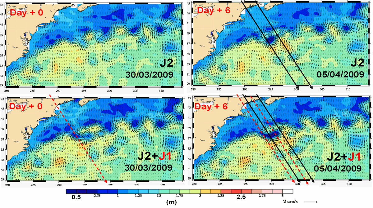
Absolute dynamic topography in the Gulf Stream region, seen by one satellite only (Jason-2, top) and by the Jason-2-Jason-1 tandem (bottom) at a six-day interval. Eddies are better observed, and transition much smoother with both the satellites together (eddies are not "poping up" from nowhere: see Jason-2 animation vs tandem animation (10MB each)) (Credits CLS/Cnes)
Jason-2 was launched on June 20, 2008. Now, a little more than one year later, fully operational, the satellite is fulfilling all the expectations that were put in him -- and more. Even more precise than Jason-1, with much more data near the coast and on inland waters (thanks to new tracking modes), Jason-2 is providing a seamless transition with Jason-1 on mean sea level trends.
Four months ago, Jason-1 has been shifted on a new orbit, thus forming a new tandem mission, with a enhanced coverage. Such flight configuration is providing better resolution of eddies and meanders, especially since the satellites are intercalibrated, and of the same design.
See also:
- Image of the Month, May 2003: Flying tandem
- Data: Ssalto/Duacs near-real and delayed time multimission altimeter products
References
- I. Pujol et al., Three-satellite quality level restored in NRT, poster (pdf, 3.7 MB), OSTST meeting, Seattle, 2009
- J. Willis, Jason1 Tandem Mission: Early results, keynote talk, OSTST meeting, Seattle, 2009
News
 Archives .
- Aviso Newsletter .
- Search.
- Front-page news.
- Image of the month .
- 2026 .
- 2025 .
- 2024 .
- 2023 .
- 2022 .
- 2021 .
- 2020 .
- 2019 .
- 2018 .
- 2017 .
- 2016 .
- 2015 .
- 2014 .
- 2013 .
- 2012 .
- 2011 .
- 2010 .
- 2009 .
- Dec. 2009: Understanding marine areas using satellites.
- Nov. 2009: If it's not El Niño, then it must be his brother....
- Oct. 2009: Dumont d'Urville movements measured by Doris.
- Sep. 2009: Birds track ocean eddies.
- Aug. 2009: Gliding in the sea.
- Jul. 2009: Jason-2 first year in orbit.
- Jun. 2009: A corridor of eddies.
- May 2009: Flood in the Zambezi basin.
- Apr. 2009: Cruise around Kerguelen Island.
- Mar. 2009: Striped ocean .
- Feb. 2009: Water or ice?.
- Jan. 2009: Lake heights and sizes from satellites.
- 2008 .
- 2007 .
- 2006 .
- 2005 .
- 2004 .
- 2003 .
- 2002 .
- 2001 .
- 2000 .
- 1999 .
- 1998 .
- Operational news and status .