


Understanding marine areas using satellites
Image of the Month - December 2009
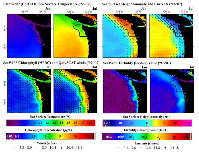
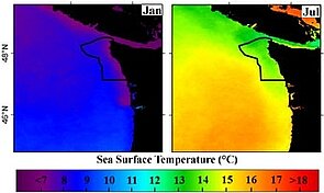
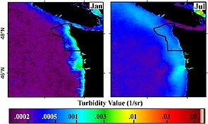
Monthly averaged satellite oceanographic data during January (peak of winter downwelling period), and July (upwelling period). Note the changes near the coast (black line is the border of Olympic Coast National Marine Sanctuary). (Credits Noaa)
Marine Protected Areas have been instituted around the world during the last decades or so. The Olympic Coast Marine Protected Area, on the West coast of United States (near Seattle) was established in 1994. Assessing the oceanographic environment of such protected areas, and how it varies on a seasonal scale (at first) is an important step to evaluate future trends, and better understand the marine plants and animals.
Using long series of satellite data ("climatologies"), comparing different ocean parameters (sea surface height and their anomalies, geostrophic current velocities, sea surface temperature, wind speed, chlorophyll content, turbidity...) enable to produce site characterizations and evaluations of (in particular) Marine Protected Areas.
Ongoing projects are improving altimetry data near the coasts (see e.g. experimental Coastal and Hydrology products). However, conclusions can already be made from altimetry data on areas such as the Olympic Coast Marine Protected Area. Future mission will also improve the availability of data closer to land.
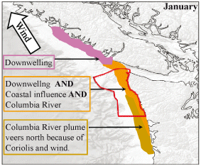
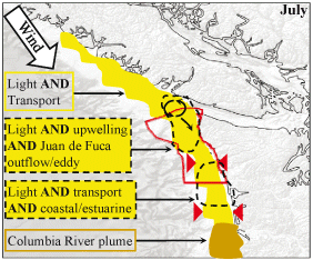
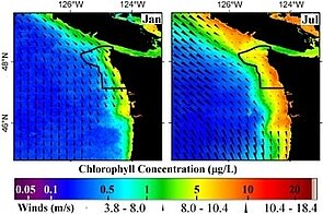
Phenomena underlying the ocean dynamics in the Olympic Coast Marine Protected area in January and July. In July, more light induces more phytoplancton. River discharge also varies, as well as wind speed and direction. All this makes a different panorama depending on the season. These schemes were deduced from studying the whole different satellite oceanographic datasets for surface processes (Credits Noaa).
See also:
- Applications: Combining sensors
- Applications: Coastal applications
- Data: Ssalto/Duacs near-real and delayed time multimission altimeter products
Website on this subject:
- An Oceanographic Characterization of the Olympic Coast National Marine Sanctuary and Pacific Northwest: Interpretive Summary of Ocean Climate and Regional Processes through Satellite Remote Sensing (Noaa Center for Coastal Monitoring and Assessment)
References:
- Pirhalla D.E., V. Ransibrahmanakul, R. Clark, A. Desch, T. Wynne, and M. Edwards. 2009. An Oceanographic Characterization of the Olympic Coast National Marine Sanctuary and Pacific Northwest: Interpretive Summary of Ocean Climate and Regional Processes Through Satellite Remote Sensing. NOAA Technical Memorandum NOS NCCOS 90. Prepared by NCCOS's Coastal Oceanographic Assessments, Status and Trends Division in cooperation with the National Marine Sanctuary Program. Silver Spring, MD. 53 pp.
News
 Archives .
- Aviso Newsletter .
- Search.
- Front-page news.
- Image of the month .
- 2026 .
- 2025 .
- 2024 .
- 2023 .
- 2022 .
- 2021 .
- 2020 .
- 2019 .
- 2018 .
- 2017 .
- 2016 .
- 2015 .
- 2014 .
- 2013 .
- 2012 .
- 2011 .
- 2010 .
- 2009 .
- Dec. 2009: Understanding marine areas using satellites.
- Nov. 2009: If it's not El Niño, then it must be his brother....
- Oct. 2009: Dumont d'Urville movements measured by Doris.
- Sep. 2009: Birds track ocean eddies.
- Aug. 2009: Gliding in the sea.
- Jul. 2009: Jason-2 first year in orbit.
- Jun. 2009: A corridor of eddies.
- May 2009: Flood in the Zambezi basin.
- Apr. 2009: Cruise around Kerguelen Island.
- Mar. 2009: Striped ocean .
- Feb. 2009: Water or ice?.
- Jan. 2009: Lake heights and sizes from satellites.
- 2008 .
- 2007 .
- 2006 .
- 2005 .
- 2004 .
- 2003 .
- 2002 .
- 2001 .
- 2000 .
- 1999 .
- 1998 .
- Operational news and status .