


New, accurate, homogeneous multi-satellite products
Pierre-Yves Le Traon, Françoise Ogor, Joel Dorandeu (CLS, Space Oceanography Division, France)
Merging data from different altimeter missions provides better space-time sampling of ocean features, needed for accurate monitoring of the ocean circulation. Such merging requires intercalibrated, homogeneous, validated, multi-satellite data sets.
Our group routinely performs this work on TOPEX/POSEIDON (T/P) data (GDR-Ms, distributed by AVISO), and ERS-1 and ERS-2 (OPRs distributed by CERSAT). For these three missions, altimetric corrections are homogeneised and the more precise T/P data are used to correct for ERS-1/2 orbit error. In practice, the computation is done by minimising the differences between T/P and ERS-1/2 measurements at crossover points (Le Traon et al., 1995a).
In 1995, AVISO distributed an initial two years of T/P data and one year of ERS-1 data (Le Traon et al., 1995b). A more complete dataset was recently distributed : four years of T/P data and three years of ERS-1 (first phase, with 35-day repeat period, and two 168-day-repeat-period cycles). The ERS-1 and ERS-2 data for the fourth year of T/P (second 35-day phase, the tandem mission) will be distributed by the end of 1997.
For the new data set, we used the T/P data recently reprocessed by AVISO (GDR-M version-C) using the JGM-3 orbit and CSR 3.0 tidal model. Some of the altimeter corrections used for the ERS-1/2 OPRs (ocean tide, dry troposphere, inverse barometer) were updated to make them homogeneous with T/P. The ERS-1/2 orbit error correction method was slightly improved, and with these more accurate initial data the ERS-1/2 orbit error can now be estimated to within 2 cm, comparable to the accuracy of the T/P orbit (Le Traon and Ogor, 1997). This is shown via theoretical analysis of the adjustment error and analysis of sea surface height differences at crossover points and along repeat tracks (see figures). The corrected ERS-1/2 data can be combined directly with the T/P data to derive better resolution, and hence better accuracy, for mapping the ocean signals. This is necessary for analysing ocean mesoscale features, for example.
As with the previous data delivery, these homogeneous T/P and ERS-1/2 data are distributed by AVISO on
CD-ROMs. The files are simplified and easy-to-use: CORrected Sea-Surface Heights (CORSSHs) and Sea Level Anomalies (SLAs). SLA data are also available through anonymous FTP.
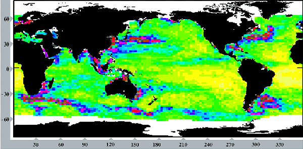
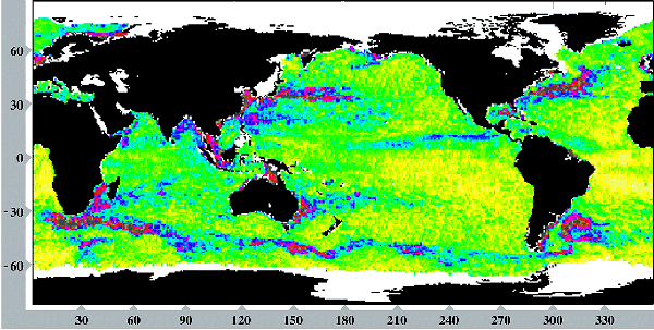
Units are in cm from 2 cm (yellow) to 32 cm (grey). The T/P and ERS-1 rms sea level variabilities are in excellent agreement. This shows that the ERS-1 orbit error has been reduced to a level comparable to T/P orbit error (2 cm).
Acknowledgements
The multi-mission data were prepared with funding from the Midi-Pyrénées Regional Council, the European Commission (via the AGORA project) and the French space agency (CNES)
References:
- Le Traon, P. Y., P. Gaspar, F. Bouyssel and H. Makhmaraa, 1995. Use of TOPEX/POSEIDON data to enhance ERS-1 data, J. Atm. Ocean. Tech., 12, 161-170.
- Le Traon, P.Y., P. Gaspar, F. Ogor, and J. Dorandeu, 1995. Satellites work in tandem to improve accuracy of data, EOS, Trans. AGU, 76, 385,389.
- Le Traon, P.Y. and F. Ogor, 1997. ERS-1 orbit improvement using TOPEX/POSEIDON: the 2 cm challenge, J. Geophys. Res.