


Sea Surface Temperature data (ATSR) vs. Sea Surface Height data (T/P)
Per Knudsen, Ole Baltazar Andersen, Thomas Knudsen (Kort & Matrikelstyrelsen, Denmark)
Along Track Scanning Radiometer (ATSR) data from the ERS-1 satellite mission are used in a global analysis of the surface temperature (SST) of the oceans. Detailed analysis of the annual cycle of the SST is performed and the result is compared to the annual cycle in the sea level anomalies (SLA) for the same period, as seen from TOPEX/ POSEIDON altimetry.
Introduction
The ATSR was designed to provide Sea Surface Temperature (SST) images with a 1 km resolution, 500 km swath and a relative accuracy of 0.1 K and SST with an absolute accuracy of better than 0.5 K and a spatial resolution of 50 km, in conditions of up to 80% cloud cover [ESA, 1992].
The instrument uses spectral channels very similar to those on the recent NOAA satellites, with many improvements in accuracy.
Early validations of the ATSR SST data have shown that the ATSR data are consistent with the 0.5 K accuracy objective [Forrester et al., 1993]. Furthermore, Barton et al. [1994] demonstrated the increased accuracy of the ATSR SST products over the AVHRR data in a comparison to in situ measurements.
In this analysis the low resolution ATSR data from the ERS-1 satellite mission are evaluated with respect to a recovery of the spatial and the temporal characteristics of the annual cycle of the SST. Finally, the seasonal variability of the SST is compared with the seasonal sea level height variability obtained from the TOPEX/POSEIDON mission (herein-after T/P).
The processing of ATSR and T/P data
The 50 km resolution, or more pre-cisely the 0.5° by 0.5° average temperatures from August 1993 through May 1996, are used. The 500 km swath scanning across the satellite ground track results in an almost global coverage every three days. Unfortunately, the 3.7 m sensor failed in May 1992 [Llewellyn-Jones, 1994], which means that some erroneous night time data are left undetected. These erroneous tem-peratures are typically caused by fog, and are about 5-12 K below the normally observed SST [Jones et al., 1995]. Therefore a procedure for the detection of the erroneous data is needed. This procedure removes an observation if the temperature, relative to a local mean and annual variation is outside a range of three times the local standard deviation. Note that the editing criteria are computed using day data only (Knudsen et al., 1996).
The ATSR SST data were averaged in cells of one by two degrees in latitude and longitude respectively, in time intervals corresponding to the 10-day repeat-cycles of the T/P mission. Subsequently, SST anomalies were formed through removal of the mean temperature in the respective cells.
Sea level height anomalies covering the same period as the ATSR data were obtained using satellite altimetry from the T/P mission. In addition to the standard corrections (altimeter sensor effects, electromagnetic bias, ionosphere, wet troposphere, and dry troposphere) also a 100% inverse barometer correction was applied [Callahan, 1993] in order to avoid effects of seasonal changes in the atmospheric pressure. Geophysical corrections for ocean tides, earth tides, and pole tides were applied. The precise orbits were computed with the JGM-3 Gravity Field model and the latest force models, and a new ocean tide correction based on the UT/CSR 3.0 model was applied. Subsequently, the altimeter data were processed using a similar averaging as for the ATSR data forming the sea level anomalies (SLA).
Characteristics of the annual cycles
Global maps of the amplitudes and phases of the annual cycle of the SST are shown in figure 1 (A & B). As seen in Figure 1A, the amplitudes of the annual signal have the largest values in the latitude belt from 25°N to 50°N. Off the east coasts of the continents where continental air is moved eastward by the predominantly westerly winds, maximum amplitudes of 6-7°C are found. Similar values are seen in the Mediterranean Sea. The largest amplitudes in the southern hemi-sphere are found between latitudes 30°S and 40°S where values between 2-4°C are found.
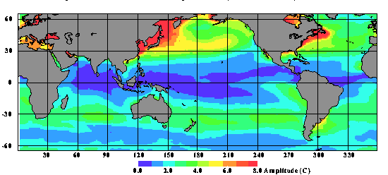
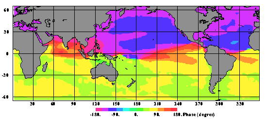
Figure 1: Annual Cycle of Sea Surface Temperature (ERS-1 ATSR).
Spatially, the phases of the annual cycle of the SST (fig. 1B) are generally shifted by 180° between the two hemispheres: in each of the hemi-spheres the surface temperatures reach their maximum after summer heating. In the northern hemisphere maximum temperatures occur in late August and early September, and in the southern hemisphere maximum temperatures occur in late February to early March. Off the east coasts of the continents the phases are slightly smaller than further east. A detailed study of the phases at mid latitudes in the North Pacific ocean show that the phase changes by about 20 days from late August to mid September going east from the coast of Japan towards the centre of the ocean. A similar phase change, though smaller, is found in the North Atlantic ocean.
The annual cycle of the SLA is shown in figure 2 (A & B) and displays features quite similar to those shown by earlier analysis of the annual cycle from satellite altimetry [e.g., Knudsen, 1994; Zlotnicki et al., 1989]. In both mid-latitude belts the amplitudes (fig. 2A) vary similarly to the amplitudes of the annual cycle of the SST . Off the east coasts of the northern continents the highest amplitudes are found (9-11 cm). In the southern hemisphere the largest amplitudes (4-5 cm) are found between latitudes 30°S and 40°S. Note that this is slightly further to the south than the corresponding maximum in the SST .
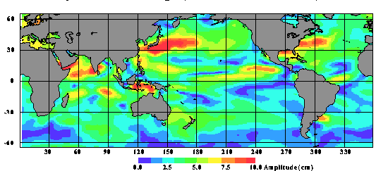
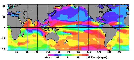
Figure 2 : Annual Cycle of Sea Surface Temperature (TOPEX/POSEIDON 1-135).
The phases of the annual cycle of the SLA (fig. 2B) in the two mid-latitude bands are shifted by a little more than one month relative to the phases of the annual cycle of the SST . Also the high SLA values off the east coasts appear to reach their maximum slightly earlier than further east in the middle of the oceans. At mid latitudes in both the North Pacific ocean and the North Atlantic ocean the phases change from late September to early October.
In the equatorial regions the annual signal from the SLA is much more detailed than the annual cycle of the SST . Here the change in the sea level height depends more on seasonal changes in the winds [e.g., Gill and Niiler, 1973; Knudsen, 1994].
On average in the northern midlatitude band (2°5N-5°0N), the amplitudes of the annual cycle are 4.5°C and 4.9 cm for the SST and the SLA, respectively.
The corresponding cosine phases are 7.7 and 8.9 months, respectively. Hence, the amplitude ratio is about 1.1 cm/C and the phases differ by 1.2 months. In the southern mid latitude band (25°S-50°S) the amplitudes of the annual cycle are 2.5°C and 2.7 cm for the SST and the SLA, respectively. The cosine phases are 1.9 and 2.8 months, respectively. Here the amplitude ratio is about 1.1 cm/°C as in the northern latitude band. The phases differ by 0.9 months.
The SST values agree remarkably well with Shea et al. [1991] who found maximum SST in the northern hemi-sphere to occur in late August to early September which corresponds to a phase of 8 months. In the southern hemisphere Shea et al. found maximum SST in late February corre-sponding to a phaseclose to 2 months.
Conclusion
A global analysis of the seasonal cycle of the SST has been investigated and compared with the seasonal cycle of the sea level height variability obtained from the T/P mission. At mid-latitudes, considering a phase difference of about one month, the correlation is very high.
The correlation is poor in the equatorial regions where the sea level vari-ability depends more on the wind. Also on shorter length and time scales the ATSR data are expected to provide valuable information about the ocean dynamics [Jones et al., 1995]. Such analysis has previously been presented using Geosat altim-etry and AVHRR data by Vazquez et al. [1990].
Acknowledgments
<h>This analysis is a contribution to a project supported by the Danish Space Board. The authors wish to thank ESA/ESRIN for the ATSR data. D. Chambers, CSR, Univ. of Texas at Austin prepared the T/P sea level anomalies. </h>
References
- Barton, I.J., C.T. Mutlow, A.M. Zavody, and D.T. Llewellyn-Jones, Intercomparison of AVHRR et ATSR data and data products, Proc. Second ERS-1 symposium, Space at the Service of our Environment, Germany, ESA Spec. Publ. 361, 1099-1102, 1994.
- Callahan, P, TOPEX/POSEIDON project GDR users handbook, Rep. JPL D-8944, rev A, 84 pp., Jet Propuls. Lab., Pasadena Calif, 1993.
- European Space Agency (ESA), ERS user handbook, ESA Spec. Publ. 1148, 128pp, 1993.
- Forrester, T.N., T.H. Guymer, and P.G. Challenor, Preliminary validation of ATSR sea surface temperatures near the Faeroes, Proc. First ERS-1 symp., Space at the Service of our Environment, ESA Spec. Publ. 359, 807-814, 1993.
- Gill A.E. and P.P. Niiler, A theory of the seasonal variability in the ocean, Deep Sea Res., 20, 141-177, 1973.
- Jones, M.S., M.A. Saunders, and T.H. Guymer, Reducing cloud contamination in ATSR averaged sea surface temperature data, à paraître dans J. Atmos. Oceanic Technol., 1995.
- Knudsen, P., Global low harmonic degree models of the seasonal variability and residual ocean tides from TOPEX/POSEIDON altimeter data, J. Geophys. Res., 99, 24643-24655, 1994.
- Knudsen, P., O.B. Andersen, and T. Knudsen, ATSR sea surface temperature data in a global analysis with TOPEX/POSEIDON altimetry, Geophys. Res. Lett., Vol. 23, No. 8, 821-824, 1996.
- Llewellyn-Jones, D.T., Water surface temperature, Proc. Second ERS-1 symposium, Space at the Service of our Environment, Germany, ESA Spec. Publ. 361, 1079-1080, 1994.
- Shea, D.J., K.E. Tranberth, and R.W. Reynolds, A global monthly sea surface temperature climatology, J. Climate, 5, 987-1001, 1991.
- Vazquez, J., V. Zlotniki and L.-L. Fu, Sea level variabilities in the Gulf stream between Cape Hatteras and 50°W - A Geosat study, J. Geophys. Res. 95, 17957-17964, 1990.
- Zlotnicki, V., L.-L. Fu, and W. Patzert, Seasonal variability in global sea level observed with Geosat altimetry, J. Geophys. Res., 94, 17959-17970, 1989.